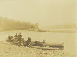
Photograph depicts five men loading packed bags into a long boat belonging to Mac McGarvey. The boat is resting near the shore of an inlet at Rolla Landing.
Six men visible on hillside and wood plank roadway, working together to roll cut logs down the hill and load them onto the truck.
Handwritten annotation in pencil on verso read: “logs up to 32 feet in length.”
Photograph depicts a loader filling a truck with dirt from the damaged road near Moricetown.
Photograph depicts a loader dumping dirt from a damaged road near Moricetown.
Photograph depicts a pack horse train heading up a snow-covered path along a mountain trail. The environment around the sloping mountain trail is sparsely covered with trees.
Photograph depicts a train of pack horses carrying loaded packs and walking up a mountain trail.
Photograph depicts a loaded packhorse carrying Prentiss Gray's camera equipment.
Slide depicts a close up of a llama eating hay. The photograph was taken in Kaleden, BC. Original slide index description: "Llama, Kaleden."
Image depicts numerous fallen trees and two unknown individuals somewhere in the Crooked River Provincial Park, near the Livingston Springs.
Image depicts the Livingston Springs in the Crooked River Provincial Park.
Image depicts the Livingston Springs in the Crooked River Provincial Park, with an unknown individual present.
Slide depicts a close up of a lion lying on wood shavings in an enclosed area. The photograph was taken in Kaleden, BC. Original slide index description: "lion, Kaleden."
Marsh along the edges of Eagle Lake features tall riparian plants and lily pads. Handwritten annotation in pen on verso reads: “Eagle Lake.”
Image depicts what is possibly the Lillooet River, full of driftwood.
Image depicts the Lillooet River delta at the head of Lillooet Lake.
Image depicts the Lillooet River at the head of Lillooet Lake.
Image depicts an area around Lillooet, B.C. It is possibly the Fraser River running through the Moran Canyon.
File contains slides depicting places in the Lillooet area.
Image depicts a view of the Fraser River and the mountains surrounding Lillooet, B.C.
Image depicts a view of the mountains surrounding Lillooet, B.C.
Image depicts rows of water, possibly being irrigation ditches, somewhere in Lillooet, B.C.
File contains slides depicting places around and between Lillooet and Howe Sound.
Image depicts some farmland in Lillooet, B.C.
Image depicts two bridges over the Fraser River, located somewhere in Lillooet, B.C.
Image depicts a view of Lillooet, B.C.
Building visible behind fence in background. Photograph taken at Government House in Victoria, B.C.
File contains slides depicting places in and around the areas of Likely and Horsefly, B.C.
Image depicts a bridge, and the town of Likely on the the other side of a river.
The Lieutenant Governor stands next to bridge and highway at top of image, cliffs and white water rapids visible below.
Handwritten annotation on verso reads: “Her Highness, Iona + Wanda planting rhodo 'R Fraseri' at Ucluelet. BC, May 26 2007, photo by Cathy Dale”; stamp on verso reads: “Government House, Jun 21 2007, Victoria”.
Handwritten notation affixed to verso reads: “Stikine Canyon Sept 2006”.
Image depicts the Lheidli T'enneh Burial Grounds in Fort George Park.
Image depicts a building, possibly an office building, next to a set of rail road tracks in Leo Creek, B.C. An unknown individual is present, and a number of barrels and culverts are visible in the foreground.
Image depicts a few piles of culverts in Leo Creek, B.C.
Image depicts the BCR station in Leo Creek, B.C.
Image depicts a view of the Fraser Lake from Lejac, B.C.
Image depicts several individuals seated on a ferry as it possibly departs from a dock somewhere in Prince Rupert, B.C. It is most likely headed for Haida Gwaii, B.C.
Image depicts numerous boats docked by the Prince Rupert Fishermen's Co-operative Association from the deck of a ferry, possibly as it's leaving Prince Rupert, most likely for Haida Gwaii.
File consists of notes, reproductions, and letters relating to L.C. Gunn Park in Prince George. Includes: "Signage for Gunn Park" letter from Kent Sedgwick to the Mayor and Council (21 Dec. 1989); "L.C. Gunn viewpoint a proposal" documents within a duotang (1987); and "Donation to the City of Prince George" typescript letter from Graham Farstad to the Administration Committee ( 1 June 1988). Includes photographs depicting the opening of L.C. Gunn Park and the sign unveiling (3 Oct. 1988).