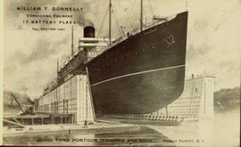
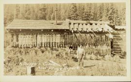
Showing 143 results

Archival description
143 results with digital objects Show results with digital objects
2009.7.1.264 · Item · [ca. 1880-1920]
Part of Archdeacon W. H. Collison fonds

Illustration of a large ocean liner in dry dock. The name "Minnesota" is inscribed on the top right side of vessel. Annotation on recto reads: "William T. Donnelly Consulting Engineer 17 Battery Place Tel. Rector 1491 20000 tons pontoon floating dry dock Prince Rupert, BC"
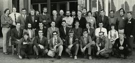
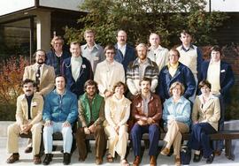
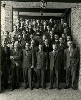
2009.7.1.261 · Item · 8 August 1909
Part of Archdeacon W. H. Collison fonds

Photograph shows two men and a cart full of lumber at a street intersection. Various residential buildings are visible in the background and atop a large clear cut hill. Annotation on recto reads: "3rd, 4th Aves and Fullton St. Prince Rupert. BC. Allen Photo 8/Aug/09."

2009.7.1.260 · Item · 24 April 1913
Part of Archdeacon W. H. Collison fonds

Foreground shows a rocky shore covered in debris. A small crowd is visible along the coastline, and there are foggy outlines of hills beyond the water. Annotation on recto reads: "McRae Bros After the Blast 24th Apr. 13."

2020.4.8.2.009 · Item · [1977 or 1978]
Part of G. Gary Runka fonds

Photograph is a group portrait of BC Agricultural Land Commission staff members at a Christmas party. Back row, left to right: Patti, Terry Lewis, unknown, Julie Glover, Gordon Gram, Gary Holisko, Kirk Miller, unknown, Shirley Brightman. Middle row, left to right: Eve Lew, Jim Plotnikoff (Santa). Front row, left to right: Verona Hoosen, unknown, Jane Perch, Denise Jankovich, unknown, unknown.

2020.4.8.2.006 · Item · [ca. 1970]
Part of G. Gary Runka fonds

Photograph is a group portrait of the British Columbia Canada Land Inventory team. Back row, left to right: Rob Hawes, unknown, Ivan Cotic, Terje Vold, John Wilcox [?], Keith Valentine, unknown, Alec Green [?], Horst Baender, Dick Marshall, unknown, John Senyk, Bill Watt, Neville Gough, Dan Blower, unknown, Gavin Young, Craig Brownlee. Middle row, left to right: unknown, Peter Murtha, unknown, unknown, John Harris, Al Aldred, Gary Runka, Ed Oswald, Mary Redmond. Front row, left to right: Rick Williams, Gerry Howell-Jones, Chris Stanley-Jones, Larry Lacelle, John Jungen, Tom Pierce, Jim Van Barneveld.

Bridges at Telkwa River
2020.05.19 · Item · [Sept. or Oct. 1936]
Part of Gordon Wyness Album

Photograph depicts two bridges crossing the Telkwa River. Wyness notes (on photograph verso) that this is where their survey crew traversed the river; he also noted erosion in the area.

Campsite at Sheraton
2020.05.29 · Item · [Sept. or Oct. 1936]
Part of Gordon Wyness Album

Photograph depicts (from left to right) Gordon Wyness and Jack Lee at their campsite at Sheraton. This location may reference the small community east of Burns Lake on the Canadian National Railway line. Wyness notes that "Sherton" [Sheraton?] Mountain is visible in the background of the photograph; the current name of that geographical feature could not be determined. The survey crew's car and tent are also visible in the image.

2020.4.8.2.005 · Item
Part of G. Gary Runka fonds

Photograph is a group portrait of the Canada Land Inventory team , possibly related to the National Soil Survey. Individuals identified: Norm Sprout (back row, 5th from left); Les Lavkulich (back row, 6th from left); Dr. Charlie Rowles (back row, 6th from right); Pat Duffy (3rd row back, 6th from right); Gary Runka (3rd row back, 5th from right).

2020.4.8.2.008 · Item · [197-?]
Part of G. Gary Runka fonds

Photograph is a group portrait of the attendees at a Canada National Land Use meeting. Back row, left to right: Gary Runka, Bruce Chambers, Frank Heaps, Vern Spencer, Peter Whiting. Middle row, left to right: Bob Scace, Lee Munn, Bill Bourgeois, Jim Murphy, Gerry Acott, Dave Rochefort. Front row, left to right: Mike Simmons, Les Cooke, John Hetherington, Betty McGregor, Daniel Paquette, Peggy Thompson, Patsy Murphy.

Centre Street Prince Rupert
2009.7.1.251 · Item · ca. 1880-1920
Part of Archdeacon W. H. Collison fonds

Photograph of residents in motion on Centre Street in Prince Rupert. Buildings are visible on either side of the street and a railway track runs down the length of the road. Annotation on recto reads: "Centre Street, Prince Rupert, BC. 1664."

Chasm
2020.05.48 · Item · 1936
Part of Gordon Wyness Album

Photograph depicts "The Chasm" or "The Painted Chasm", located 11 miles north of Clinton, adjacent to the route of the Cariboo Road. In 1940, four years after this photograph was taken, Chasm Provincial Park was created in 1940 to preserve and promote the Painted Chasm feature, a gorge created from melting glacial waters eroding a lava plateau over a 10 million year span.

Chasm, BC
2020.05.47 · Item · 1936
Part of Gordon Wyness Album

Photograph depicts "The Chasm" or "The Painted Chasm", located 11 miles north of Clinton, adjacent to the route of the Cariboo Road. In 1940, four years after this photograph was taken, Chasm Provincial Park was created in 1940 to preserve and promote the Painted Chasm feature, a gorge created from melting glacial waters eroding a lava plateau over a 10 million year span.

2011.3.3.82 · Item · 1 July 1910
Part of North Coast & Central BC Postcard Collection

Slightly elevated street view of buildings and sidewalks being constructed in Prince Rupert, BC. Printed annotation on recto reads: "Photo by McRae Bros. Third Ave Prince Rupert, BC." Handwritten annotation on verso reads: "Dear Florence you better [illegible] will try and answer it in a few day I am well I will try and send you some cards I will stay here till in Dec Write[??] me and send me some cards I am 15 mile in the mountains Write your Bro LS Bill." Postcard is addressed to: "Miss Florence Wilson P.O. Box 1178 Worcester Mass U.S.A." A 2 cent Canadian stamp is affixed on verso. Postmark reads: "Prince Rupert BC Jul 1 10."

2020.4.8.2.007 · Item · 1 Apr. 1971
Part of G. Gary Runka fonds

Photograph is a group portrait of the attendees at the Federal-Provincial Canada Land Inventory Coordinators Meeting in Victoria, March 31-April 1, 1971. Starting from the back row, left to right, attendees included: John Senyk, B.C.; Jim Allin, B.C.; Fred Frederickson, B.C.; Red Ward, Ontario; George Rathwell, Saskatchewan; John Foster, Ottawa, Charlie Rowles, B.C.; David Glover, Ottawa; Bill Yeomans, B.C.; Don Coombs, Ottawa; Harold Hoyt, N.B.; Brian King, Ottawa; Art Benson, B.C.; Scott Johnston, Ottawa; Dan Blower, B.C.; Vic Solman, Ottawa; Don Benn, B.C.; Dick Spilsbury, B.C.; Les Lavkulich, B.C.; Doug Lacate, B.C.; John Wilcox, B.C.; Alf Leahey, B.C.; Mike Romaine, Ottawa; Dick Marshall, B.C.; Gary Runka, B.C.; Norm Sprout, B.C.; Ken Beanlands, Newfoundland; Mick Roberts, Ottawa; Paul Lajoie, Ottawa; Pat Duffy, Ottawa; Bert Brink, B.C.; Merv McKay, Manitoba; Rich Goulden, Manitoba; Reg McCormack, Ottawa; Gerry Howell-Jones, B.C.; Marcel Belzile, Quebec; Paul Deane, Ottawa; Laurie Farstad, B.C.; Stu Scott, Alberta.

2009.7.1.266 · Item · 14 June 1911
Part of Archdeacon W. H. Collison fonds

Photograph of a large crowd gathered in front of a Grand Trunk Pacific train. Residential buildings atop a hill are visible in the background. Annotation on recto reads: "First Train Leaving Prince Rupert June 14 1911"

François Lake Ferry
2020.05.51 · Item · Sept. 1936
Part of Gordon Wyness Album

Photograph depicts the Francois Lake Ferry. Gordon Wyness stands next to the survey crew's Buick car in the middle of the boat. Jack Lee leans on the railing at the back of the boat.

François Lake from ferry
2020.05.49 · Item · 1936
Part of Gordon Wyness Album

Photograph depicts a view of François Lake taken from the ferry going to Northbank Point on right-hand side. The survey crew camped there in June 1936.

G. Gary Runka fonds
2020.4 · Fonds · 1945-2013

This fonds illustrates the life and work of G. Gary Runka and his contributions to the province of British Columbia. Gary Runka was the first General Manager of British Columbia's Agricultural Land Commission and helped establish the provincial Agricultural Land Reserve. After transitioning from a government career to private consulting, Runka provided comprehensive professional services through his land consultancy business, G.G. Runka Land Sense Ltd., offering land capability and environmental assessments, integrated resource management, land and water use conflict resolution, and interdisciplinary land use planning. Described by colleagues as one of BC's most highly respected agrologists and influential land use planners, Runka had a 52-year career working on (or against) an incredible number of landmark projects in British Columbia, such as the Site C Project. Gary Runka’s partner in life and vocation, Joan M. Sawicki, worked with Gary on many of these projects—as well as her own; her contributions are also represented throughout the records of this fonds.

Gary Runka's deep connection to the land is evident from his earliest papers on aerial photo interpretation, his work with the Canada Land Inventory, through his speeches and his work establishing the BC Agricultural Land Reserve and in his subsequent consulting career through G.G. Runka Land Sense Ltd. Gary Runka's influence and legacy was recognized in the tributes paid after his death, including the post-humus award as the Real Estate Foundation's "Land Champion" for 2014.

The G. Gary Runka fonds has been divided into the following nine series:
1) Personal Records
2) Speeches & Publications
3) Professional Records
4) Agricultural Land Commission
5) Land Sense Ltd.
6) Client Files
7) Maps
8) Photographs
9) Digital Records

Runka, G. Gary
Gordon Wyness Album
2020.05 · Collection · 1936

In 1936, Gordon Young Wyness was employed by Philip M. Monckton, a B.C. Land Surveyor. Between June 5 and October 8, Wyness joined Monckton and a group of others on a land survey expedition in northwestern BC. The survey crew travelled to various locations in the area including Telkwa, Hazelton, Burns Lake, Francoise Lake, Vanderhoof, Prince George, Quesnel, Lytton, and Hope. Wyness documented their journey in this photograph album. Based on the photographs, it appears that the crew led by Philip Monckton consisted of Jack Lee and Gordon Wyness; Mrs. Lavender Monckton (nee O'Hara) also accompanied the group.

In addition to the 50 photographs included in the album, this collection also includes five additional unique photographs that accompanied the album.

Wyness, Gordon Young
2020.05.15 · Item · [Sept. or Oct. 1936]
Part of Gordon Wyness Album

Photograph depicts (from left to right) Gordon Wyness and Jack Lee at a camp scene "at Bobtail" (possibly Bobtail Lake) near Vanderhoof. As noted in the album caption, the crew had "just returned from Vanderhoof". The telegraph cabin roof and their 1930 Buick Series 40 car is visible at right.

2020.05.11 · Item · [Sept. or Oct. 1936]
Part of Gordon Wyness Album

Photograph depicts (from left to right) Gordon Wyness and Jack Lee in front of the Fort St. James sign, which reads "First white settlement in British Columbia. Established by the North West Company in 1806 by Simon Fraser and John Stuart and taken over by the Hudson's Bay Company in 1821. - General Merchandise Visitors Welcome".

2020.05.44 · Item · 1936
Part of Gordon Wyness Album

Photograph depicts Gordon Wyness sitting on a historic boat, which he described as built ca. 1860 and could carry "7 Indians" and 5000 lbs of freight up the river. Located nearby is a telegraph cairn erected to commemorate the Collins Overland Telegraph lines that began in Quesnel in 1865. Until 1907, Quesnel was the terminus for the telegraph line. Behind Wyness is a replica of a Cornish water wheel that was originally located at Williams Creek in Barkerville. This location is now called Ceal Tingley Memorial Park-Heritage Corner and is located along Front Street in Quesnel, near the Fraser River Bridge. The cairn and water wheel still stand in this location, however the boat was removed around 1941.

According to additional information from Quesnel & District Museum & Archives, Wyness may have been provided with inaccurate information about the canoe depicted. The canoe believed to have been located at that spot was actually created in 1905 to pack out the Grand Trunk Preliminary Survey Team, which was led by J.M. Rolston.

2020.05.10 · Item · Sept. 1936
Part of Gordon Wyness Album

Photograph depicts (from left to right) Gordon Wyness, Philip Monckton, and Lavender Monckton by their 1930 Buick Series 40 car in the Williams Lake area. In this image, the car may be broken down; Wyness noted that they "were forced to spend the nite in a school house due to condenser burning out in the car". Wyness also noted that they had "just finished tying in Fraser Mtn", suggesting that they had just completed survey work in the Fraser Mountain area.

2000.16.2.4 · Item · 1906
Part of Prince Rupert Empire collection

Item is a copy print of a photograph of a group of people in a cleared area with a small tent in the background in Prince Rupert on June 1, 1906. The people in the photograph are identified as: Mrs. J.L. Williams, Jack or Jock Williams, Mrs. Porter, Miss Mai Johnston, Mrs. R.L. McIntosh, J.H. Pillsbury, Mr. Pinder ? (Engineer), Captain Jenner ?, Mrs. S.G. Harris, and Cannon Rushbrook.