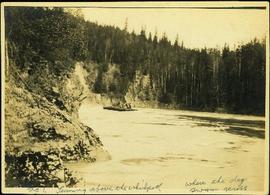
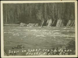
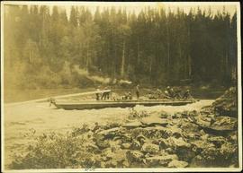
Photograph depicts a crew of 13 men on a scow believed to be maneuvering through the Upper Fraser River at Scow's Last Lap (Scow Rapids), downriver from the Grand Canyon of the Fraser. Trees on opposite shore in background, rocky shore in foreground. Handwritten annotation on recto of photograph reads: "the last lap".
Photograph depicts men on a scow, maneuvering what is believed to be the Upper Fraser River. Opposite shore in background, close shore in foreground. Handwritten photo caption below this photo reads: "1. Turning above the whirlpool where the dog swam across."
Postcard image of a scow on the rocks in the Upper Canyon, Fort George
Photograph depicts men on a scow in distance at bend in river. Unidentified objects or structures on opposite shore in background, rocky shore in foreground. Handwritten photo caption on verso and recto of this photo reads: "Scow coming through upper Grand Canyon".
Photograph depicts men on a scow near opposite shore of river. Treetops in foreground. Photograph taken from above. Handwritten photo caption on verso and recto of this photo reads: "in the lower Grand Canyon".
Photograph depicts men on river scow in distance. Rocks in foreground, trees and cliffs on opposite shore in background. Handwritten annotation on verso of photograph: "Scow in Upper Grand Canon. Fraser River. B.C.."
Photograph of a scow traveling down the tumultuous Fraser River. Printed annotation on recto reads: "Scow in Grand Canon Fraser River."
Photograph depicts a scow owned by Island Tug and Barge Ltd.
Photograph depicts a Sawyer Massey traction engine in Nanton, Alberta. The device parallel and topside of the boiler to heat feed water. The water tank is small so it must have had a water cart in constant attendance.
Photograph depicts a Sawyer Massey steam engine in Nanton, Alberta. It was built in Hamilton, Ontario. It has a single cylinder and large fire box for burning wood or straw.
Image depicts machinery in a saw mill somewhere in Prince George, B.C.
Photograph depicts a sawmill at the edge of Okanagan Lake at the north end of downtown Kelowna. The end of a chip loading spur is visible on the left.
Photograph depicts a sawmill yard at CPR yard adjacent to barge slip at the end of the branch line. Slocan Lake is in the distance.
Hand coloured photo of a clearing in Prince Rupert with a sawmill in the distance. Printed annotation on recto reads: "Prince Rupert, B.C. : Saw Mill Grand Trunk Pacific Railway." Artist's stamp in the lower right corner reads: "103112 J.V."
Photograph depicts a group of four adults standing in front of car parked on road. Forest and unknown building in background. Left to right: Judge Fisher, Mrs. [Laird?], unidentified taxi driver, Sarah Glassey. Handwritten annotation on recto of photograph: "Sarah, The Taxi driver, Mrs. [Laird?] her husband is a Dr. at the University of B.C. I am very fond of her, and an old friend of yours Judge Fisher used to be just good old Billy Fisher."
Photograph depicts Sarah Glassey wearing overalls and hat, seated on horse. Cardboard box lies in left foreground, and a team of horses pulling wagon can be seen in background. Handwritten annotation on recto of photograph: "Myself."
Photograph depicts Sarah walking amongst people on sidewalk lined with cars and tall buildings. Power lines cross midground. Photograph believed to have been taken by street photographer. Handwritten annotation on recto of photograph: "Sarah Glassey."
Group of four women and one man stands in front of car in unidentified yard. Sarah stands on far left, buildings, wood pile, and forest in background. Handwritten annotation on recto of photograph: "[Wright Car?] Atlin." Similar group also featured in items 2009.5.2.274 - 2009.5.2.294.
Group of seven men and women stands in front of car in dirt road, forest in background. Sarah Glassey stands on far left. Similar group also featured in items 2009.5.2.275 - 2009.5.2.294.
Group of seven men and women stands in front of car. Sarah stands second from right, bushes in background. Similar group also featured in items 2009.5.2.274 - 2009.5.2.294.
The pair walks on sidewalk, wearing hats and fur lined coats, Glassey on left. Car, power lines, and tall buildings stand in background. Photograph believed to have been taken by street photographer.
Two woman stand on road in front of car, trees and second parked car in background. Woman on left speculated to be Sarah Glassey. Handwritten annotation on recto of photograph: "Auntie + friend + the car."
Photograph depicts small log buildings and loaded wagons in cleared dirt area. Building on far left has the sign "POOL HALL" posted on front . Treetops, lumber piles, and hills in background. Mountains can be seen in distance. Handwritten annotation on verso of photograph reads: "Sand Creek. B.C."
Photograph depicts a sand car at the Great Northern Railway depot in Vancouver, beside the Canadian National Railway (CN) depot.
Photograph depicts sample lettering that read "Canadian National Kamloops Auxiliary."
Photograph depicts sample lettering that read "CN Kamloops Auxiliary Dining Car."
Photograph depicts the CPR depot in Salmon Arm.
Photograph depicts Mr. Crysdale sitting on a velocipede on the Sallus Creek ("14 Mile") Pacific Great Eastern Railway trestle with an estimated date of very late July 1915 or later. "Canadian Railway and Marine World" reported that track had been laid to 14 miles North of Lillooet by July 30, 1915 (CR&MW , Sept 1915, p341, c2). 14 miles North of Lillooet is approximately 20 rail lengths beyond the North end of this trestle, leading to a "best estimate" of very late July 1915 as the earliest date for this photograph. The velocipede depicted is a 3-wheel, manually propelled vehicle operated by a push-pull (back & forth) action on the actuating handle.
The ca. 1921-1927 “PGE Bridge List” from the notebook of William H. Hewlett (1914-1968) references a Mile 13.7, 14 Mile Creek, frame trestle, 905 ft. long, 182 ft. high, 61 spans of 14.8 feet in the Lillooet Subdivision. A “PGE Track Profile” drawing shows this trestle was on a 1.55% grade and a 12 degree left hand curve. While the drawing had been revised at least twice (with an unknown date for the most recent revision), the pre-“Lillooet Diversion of 1931" mileage figures confirm that the 1915 “Mile 13.7" was in agreement with a more recent hand written note “Sallus Creek”. The trestle appears to have gone by the names "14 Mile" trestle, "13.7 Mile Trestle", and "Sallus Creek" trestle.
Photograph depicts a partially constructed Pacific Great Eastern Railway trestle located near Sallus Creek in the area around Lillooet, Fountain, and Pavilion. "Canadian Railway and Marine World" reported that track had been laid to 14 miles North of Lillooet by July 30, 1915 (CR&MW , Sept 1915, p341, c2). 14 miles North of Lillooet is approximately 20 rail lengths beyond the North end of this trestle, leading to a "best estimate" of early-mid July 1915 as the latest date for this photograph.
The ca. 1921-1927 “PGE Bridge List” from the notebook of William H. Hewlett (1914-1968) references a Mile 13.7, 14 Mile Creek, frame trestle, 905 ft. long, 182 ft. high, 61 spans of 14.8 feet in the Lillooet Subdivision. A “PGE Track Profile” drawing shows this trestle was on a 1.55% grade and a 12 degree left hand curve. While the drawing had been revised at least twice (with an unknown date for the most recent revision), the pre-“Lillooet Diversion of 1931" mileage figures confirm that the 1915 “Mile 13.7" was in agreement with a more recent hand written note “Sallus Creek”. The trestle appears to have gone by the names "14 Mile" trestle, "13.7 Mile Trestle", and "Sallus Creek" trestle.
Photograph depicts the Pacific Great Eastern Railway trestle located near Sallus Creek in the area around Lillooet, Fountain, and Pavilion. "Canadian Railway and Marine World" reported that track had been laid to 14 miles North of Lillooet by July 30, 1915 (CR&MW , Sept 1915, p341, c2). 14 miles North of Lillooet is approximately 20 rail lengths beyond the North end of this trestle, leading to a "best estimate" of very late July 1915 or later as the earliest dates for this photograph.
The ca. 1921-1927 “PGE Bridge List” from the notebook of William H. Hewlett (1914-1968) references a Mile 13.7, 14 Mile Creek, frame trestle, 905 ft. long, 182 ft. high, 61 spans of 14.8 feet in the Lillooet Subdivision. A “PGE Track Profile” drawing shows this trestle was on a 1.55% grade and a 12 degree left hand curve. While the drawing had been revised at least twice (with an unknown date for the most recent revision), the pre-“Lillooet Diversion of 1931" mileage figures confirm that the 1915 “Mile 13.7" was in agreement with a more recent hand written note “Sallus Creek”. The trestle appears to have gone by the names "14 Mile" trestle, "13.7 Mile Trestle", and "Sallus Creek" trestle.
Photograph depicts the Pacific Great Eastern Railway trestle located near Sallus Creek in the area around Lillooet, Fountain, and Pavilion. A number of men are working along the trestle, possibly completing final construction work or performing repairs. "Canadian Railway and Marine World" reported that track had been laid to 14 miles North of Lillooet by July 30, 1915 (CR&MW , Sept 1915, p341, c2). 14 miles North of Lillooet is approximately 20 rail lengths beyond the North end of this trestle, leading to a "best estimate" of very late July 1915 or later as the earliest dates for this photograph.
The ca. 1921-1927 “PGE Bridge List” from the notebook of William H. Hewlett (1914-1968) references a Mile 13.7, 14 Mile Creek, frame trestle, 905 ft. long, 182 ft. high, 61 spans of 14.8 feet in the Lillooet Subdivision. A “PGE Track Profile” drawing shows this trestle was on a 1.55% grade and a 12 degree left hand curve. While the drawing had been revised at least twice (with an unknown date for the most recent revision), the pre-“Lillooet Diversion of 1931" mileage figures confirm that the 1915 “Mile 13.7" was in agreement with a more recent hand written note “Sallus Creek”. The trestle appears to have gone by the names "14 Mile" trestle, "13.7 Mile Trestle", and "Sallus Creek" trestle.
Photograph depicts a saddle tank built by Porter Company, Pittsburgh, USA in 1901. It was used for charging coke ovens and was acquired from the Crows Nest Pass Coal Company in 1970.
Photograph depicts the large bearing cups of one of the Ruston Hornsby diesel engines that turned the generators in the power house on the Cassiar plant. Engine believed to be under repair. Electric panels in background.
Photograph depicts the large bearing cups of one of the Ruston Hornsby diesel engines that turned the generators in the power house on the Cassiar plant. Engine believed to be under repair. Electric panels and unidentified individual in background.
Photograph depicts the large bearing cups of one of the Ruston Hornsby diesel engines that turned the generators in the power house on the Cassiar plant. Engine believed to be under repair. Saw horse, machinery, and electric panels in background.
Item is a photograph of the Russian helicopter which Ray used to survey timber on the border between Bangladesh and Burma.
Photograph depicts team of horses pulling heavily loaded wagon with the sign: "RUDDY & MACKAY. BAGGAGE. STAGE & TRANSFER." One man stands holding head of horse and smoking a pipe. A second man sits in wagon holding reigns, (believed to be same man featured in items 2009.5.1.79 & 2009.5.1.80). Large "Grand Trunk Pacific" building can be seen in background, as well as a smaller building with the sign "HAZELTON" hanging from its eaves.
Photograph depicts a solid rubber tire on wooden spokes. It came from an early type of truck, but was now used on a two-wheel trailer carrying a tank.
Photograph depicts a wharf spur in Squamish. Visible is locomotive #2860 "Royal Hudson" and a baggage car that is running around the train prior to its departure.
Photograph taken at the BC Rail depot in North Vancouver, with "Royal Hudson" tourist train captured prior to its departure.
Photograph taken at the BC Rail depot in North Vancouver, with tourist train "Royal Hudson" departing to Squamish.
Photograph features a sign in the middle of a field at the Royal Canadian Air Force base in Whitehorse, YT that reads: "Taking Photographs Prohibited". Handwritten photo album caption below this photo reads: "Our Authority". See also items 2006.20.12.39 & 2006.20.12.43.
Royal Canadian Air ForcePlanes visible in background.
Item is one of three photographs accompanying a paper reading: “Comox Valley Air Force Museum Association, Inaugural Dedication of Heritage Stones, Sunday 04 June 2006”; see also items 2009.6.1.626 and 2009.6.1.628.
Photograph depicts a roundhouse with 16 bays at Cranbrook. Currently 7 were fitted with rails, of which 5 bays are in use. Four of these bays were holding snowplows and 2 were clearly not used. Three of the sixteen bays appear to never have been fitted with track.
Photograph depicts rolling stock on a spur trestle at the Cowichan Valley Forest Museum on Somenos Lake.
Photograph depicts the Rocky Mountaineer in downtown Kamloops.