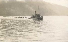
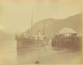
Group of men stand on pier by warehouse, looking out at the boat. Treed mountains visible in background.
Handwritten photo caption beside image reads: "Danube".
Group of men stand on pier by warehouse, looking out at the boat. Treed mountains visible in background.
Handwritten photo caption beside image reads: "Danube".
Image depicts the Duchess engine, which was built in 1878 and taken out of service in 1919. It was part of a matched set with the Duke and is now a tourist attraction in Carcross, Y.T.
Postcard depicts the Canadian Pacific Railway line where the Great Divide between BC and Alberta.
Photograph depicts the boat "John Antle" motoring on the water near a rocky, tree covered cliff. Handwritten annotation on verso states: "M.S. John Antle on her rounds entering Smuggler Cove". Stamped annotation on verso reads: “The National Film Board”
Handwritten annotation on verso reads: " '[Naskeena?' anchored off Metlakatla with Dr. [Mc-?] & Capt. Barry standing on its deck".
Stern wheeler “Port Simpson” tied to riverbank. Printed annotation on recto reads: “On the Skeena river, Hazelton, B.C.” Handwritten message on verso is addressed to “Mrs. Flossie Strong 6 Nah St. Watermill ME, U.S.A” 1 cent Canadian postage stamp has been canceled with a date of “Dec 24, 5:30 PM 1915 Buffalo N.Y.”
Photograph depicts the "Princess of Vancouver" loading at 7 p.m. in Vancouver.
Side perspective street view of the Royal Hotel in Prince Rupert BC. The "Ladies [sic] Entrance" sign is visible on the right side of the building. Several vehicles can be seen on the street. Printed annotation on recto reads: " 3rd Ave Prince Rupert Photo W.W.W."
Photograph depicts the split of the Great Northern Railway (GNR) (shown) and the Canadian National Railway (CN) tracks, immediately south of the Fraser crossing at New Westminster.
Stern wheelers “Operator” and “Conveyor” in dock. Printed annotation on recto reads: “S.S. “Operator” and “Conveyer” at Fort George, B.C. No. 107.”
Image depicts half of a ship, which is named the Tutshi, in Carcross, Y.T.
Photograph of a small vessel on the ocean with a dock and harbour buildings in the foreground. Tents and piles of lumber can be seen among the buildings. Annotation on recto reads: "The Wharf, Prince Rupert, BC. 1657."
Photo depicts a street perspective of Third Ave., in Prince George, BC, ca. 1950. Handwritten annotation in pen on verso of postcard reads: “You will undoubtedly notice that there are no tall buildings. I don’t think that there is one building in Prince George that is even five stories tall.”
Street view taken from the intersection of Third Avenue and Sixth Street in Prince George BC. A drugstore and several cafes can be seen on the left side of the street. Printed annotation on recto reads: "3rd Ave & 6th Street Prince Rupert BC."
Street view of Third Avenue in Prince Rupert. Printed annotation on recto reads: "Third Ave Prince Rupert B.C. Photo W.W.W."
Elevated view of Third Avenue in Prince Rupert. What appears to be a firetruck is travelling down the road. Printed annotation on recto reads: "3rd Ave W Prince Rupert BC."
Street view of Third Avenue in Prince Rupert, BC. Several cars are visible parked along the sides of the paved street. Printed annotation on recto reads: "Third Ave. W Prince Rupert- BC."
Street scene depicting people, boardwalks, horse & wagons, and delivery truck. Printed annotation on recto reads: “3rd Ave. Prince Rupert. B.C.”
Typed annotation in red ink on recto reads: “3rd Ave. Prince Rupert. B.C.” People, boardwalks, horse & wagons and store signs are visible. Rubble and unknown material lies on ground between boardwalks. Typed annotation in red ink on recto reads: “3rd Ave. Prince Rupert. B.C.”
Photograph depicts CN track 1 mile east of Walhachin. Looking east. Thompson River running downstream, towards the camera. CPR also goes through Walhachin.
Photograph depicts CN track 1 mile east of Walhachin. Looking east. Thompson River running downstream, towards the camera.
Photograph depicts three B.C. Electric Railway locomotives on running line to the west of car barn at New Westminster.
Photograph depicts three crossing at Second Narrows in Vancouver Harbour. On the left was a new CNR bridge being built. In the middle was exsiting CN track. To the right a high level road bridge is visible.
Item is a photograph of the three tunnels built to divert the Peace River around the Bennett Dam construction site.
Photograph depicts two men (one in uniform) standing in an airstrip under the nose of a military plane with the number "7632" on its side. A third man stands in uniform on far right, and a building can be seen in distance behind him on the flat horizon. Handwritten photo album caption below this photo reads: "MAJESTIC '32'." It is believed this photograph was taken at the military base in Whitehorse, YT.
Royal Canadian Air ForceGround level view of the Prince Rupert dry dock. Hills are visible in the background. Printed annotation on recto reads: "Three Million Dollar Dry Dock and Shipbuilding Plant, Prince Rupert, BC."
Officers are mounted on three horses standing in water. Fifth horse stands on right, trees on shore in background. Handwritten annotation on recto of photograph: "Jas Tracey, Vanderhoof. Srg. Birch."
Photograph depicts 3 unnamed railway employees posing for a photograph in front of a railroad station in an unknown location.
Photograph features three sternwheelers tied to river bank. Buildings visible on far left, hills on shore visible in background.
Printed annotation on recto reads: “Stern Wheelers 1910 Quesnel B.C.” Handwritten annotation on verso in pencil reads: “BX, B.C. Express, Charlotte”
Handwritten annotation on verso reads: "Poling supplies up Nass River".
Photograph depicts Tilbury dock on the Delta shore of the Fraser River. The stern of the Canadian National Railway (CN) onboard railcar carrier SS "Canora" is about 10ft away, and showing tidal and moving a piece of dock leading to shore.
Photograph depicts the view of the Tilbury rail terminal on the south bank of the south arm of the Fraser River, 1 1/2 miles east of Deer Island Tunnel. S.S. Canora is also in the picture.
Image depicts Highway 16 en route to Prince Rupert, B.C.
Photograph depicts winding river from above, tall trees on either side and mountains in background. Handwritten photo caption on verso and recto of this photograph reads: "Top of Grand Canyon from Portage trail".
Totem poles (crest poles?) stand in front of a line of houses. Blanketed canoes sit on beach in right foreground; forest in background.
Handwritten annotations on verso read: “skidegate village Queen Charlotte Islands as it appeared forty years ago"; "Rev W.E. Collison Prince Rupert"; "Hughes"; "1".
Photograph depicts a tug boat hauling a line of small fishing boats across the water with a mountain in the background. Annotation on verso of photograph states: "Tow of Cannery Fishing boats"
Handwritten photo album caption below this photo reads: "Tower & Adm. Bldg, Ft. Nelson." Photograph depicts long white building with tower raised in middle, ladders and scaffolding in front. Trucks and groups of men in foreground, some on building itself. Power poles in foreground and background.
Royal Canadian Air ForcePhotograph depicts a tower controlling the C.P.R. grade crossing at Alexander St. in Vancouver, B.C.
Photograph depicts horse and rope in Fraser River. Hill on opposite shore in background.
Photograph depicts a track car model (in fact, the base to the lamp shade).
Photograph depicts a CN Track Geometry 'Test" car for Western Canada. Built in 1954 as "Cape Race." In 1983 it was a VIA sleeper/buffet/lounge.
Photograph depicts a track shed about 1 mile south of Beaverdell or at about mile 43.25 on the CPR line in the Carmi Subdivision. Despite the open doors and ease of access, it was the only hut on the line found to contain track materials and correspondence. It retained 50 memos addressed to the Section Foreman [at Beaverdell?].
Photograph depicts the track transfer transporter at the Canadian National Railway (CN) repair shops at Port Mann, showing the east face of the main building.
Photograph depicts trackage near the CPR depot in Salmon Arm.
Photograph depicts the trackage in the mid section of the McCulloch depot area. The left line is a passing track, the mid line is the mainline, and the right track is for storage. The depot is located at mile 76.6, on the Carmi Subdivision. The view is looking north.
Photograph depicts a "trackmobile" in the CNR Boston Bar yard. Work on replacing ties was being carried out 5-10 miles to north.
Photograph depicts tracks made by machinery in an earth road turning left in forest.