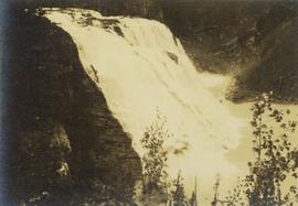
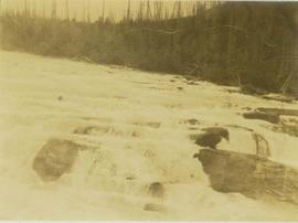
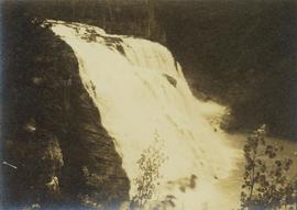
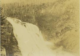
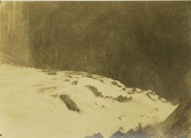
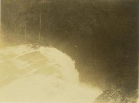
Photograph depicts the top of Kinuseo Falls, also known as Kinoosao Falls, running over a rocky shoreline with burnt trees in the background.
Photograph depicts a view of the rocky river leading to Kinuseo Falls, also known as Kinoosao Falls, with burnt trees visible in the background.
Photograph depicts a close perspective of a waterfall falling down a rocky cliff side. In the background a burnt forest environment is visible. The waterfall is know as both Kinuseo Falls and Kinoosao Falls.
Photograph depicts the top of Kinuseo Fall also known as Kinoosao Falls. In the background a barren forest is visible.
Photograph depicts a close perspective of a waterfall falling down a rocky cliff side. In the background a burnt forest environment is visible. The waterfall is know as both Kinuseo Falls and Kinoosao Falls.
Image depicts a van on a narrow road, likely the Kettle Valley Trail.
Image depicts a woman walking along a trail somewhere in Kettle Valley, B.C.
Image depicts a view of Kettle Valley, with a bridge of the old Kettle Valley Rail Road visible on a slope.
Image depicts a woman walking along the trail of the Kettle Valley Rail Road.
Image depicts the trail of the old Kettle Valley Rail Road.
Image depicts a man standing on the old Kettle Valley Rail Road.
Image depicts the old Kettle Valley Rail Road.
Image depicts several unknown individuals standing on the old Kettle Valley Rail Road.
Image depicts the Okanagan Kettle Valley, with the Kettle Rail Road faintly visible among the trees
Image depicts the trail of the old Kettle Valley Rail Road.
Image depicts a woman standing on the old Kettle Valley Rail Road.
Image depicts a view of the Okanagan Kettle Valley.
Image depicts a man fishing in the Kettle River.
Image depicts Kent Sedgwick sitting on a log with a dog on a beach somewhere in Haida Gwaii, B.C.
Image depicts Kent Sedgwick sitting with a dog on a log on the shore of Haida Gwaii, B.C.
Image depicts Kent Sedgwick sitting on a log on the shore of Haida Gwaii, B.C.
Image depicts Kent Sedgwick standing in a forest somewhere on Haida Gwaii.
Image depicts Kent Sedgwick standing on a beach in Haida Gwaii, B.C. He is holding seaweed.
Image depicts Kent Sedgwick smoking a pipe at camp, with two other unknown individuals nearby.
Image depicts Kent Sedgwick pointing out what is possibly the Robson Glacier in the background. Another, unknown individual is also present in the image.
Image depicts Kent Sedgwick crouching and holding a stick; the slug on the end is barely visible. Located somewhere on Haida Gwaii.
Image depicts Kent Sedgwick with a dog at his feet, somewhere in Mt. Robson Provincial Park.
Image depicts Kent Sedgwick walking along the coastline of Haida Gwaii, B.C.
Image depicts Kent Sedgwick speaking to a group of hikers.
Image depicts a man looking at some papers. It is most likely Kent Sedgwick.
Image depicts Kent Sedgwick sitting on the bank of a river. An old beehive burner is visible in the background. Located somewhere in or near Penny, B.C.
Image depicts a boat dock on the Nechako Reservoir at Kenny Dam.
Image depicts a boat on the Nechako Reservoir at Kenny Dam.
Image depicts Kenny Dam, south of Francois Lake, and southwest of Vanderhoof, B.C.
Image depicts a stretch of land; the photo was taken from the top of Kenny Dam, south of Francois Lake.
Image depicts the Kenney Dam near Cheslatta, B.C.
Slide depicts Kelowna and Casa Loma photographed during the day from across the Okanagan Lake in the Lakeview Heights area. Original slide index description: "Kel & Casa Loma from Lakeview Hts."
Image depicts a view of Kelly Lake Valley from Pavilion Mountain.
Image depicts a view of Kelly Lake in Downing Provincial Park.
Image depicts a blue truck and a camper in the wooded area surrounding the townsite of Keithley Creek, B.C.
Image depicts a sign on the dirt road leading to Barkerville from Keithley Creek. The sign reads: "Barkerville 40 (via Yanks Peak) Maximum elevation 6200 FT. Summer road only. Steep grades and switchbacks not recommended for other than 4-wheel drive vehicles. You are entering an isolated mountain area; you will be on your own."
Image depicts the townsite of Keithley Creek, B.C.
Image depicts the Keithley Creek, with several unknown individuals walking along the banks.
Lofty view of Kaien Island, with other islands in the background. Printed annotation on recto reads: "Kaien Island, Prince Rupert, B.C., showing Water Front of four miles on Prince Rupert Harbor."
Image depicts a junk pile of bottles, cans and bags, as well as the gutted frame of an old car, at Island Cache.
Image depicts a road, possibly Joffre Creek Road. The slide is simply labelled "Joffre cr."