2020.4.7.013
·
Item
·
1982
Part of G. Gary Runka fonds
3615 results with digital objects
Show results with digital objects

2012.13.1.78.32
·
Item
·
1982
Part of J. Kent Sedgwick fonds
Image depicts a building surrounded by a tall, circular enclosure somewhere on Haida Gwaii, B.C.

2012.13.1.87.088
·
Item
·
[between 1980 and 2000]
Part of J. Kent Sedgwick fonds
Image depicts employee houses on mill site in Giscome, B.C. Tug boats are in the foreground on the right. Map coordinates 54°04'23.4"N 122°22'16.9"W
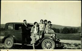
2009.5.4.38
·
Item
·
[ca. 1930]
Part of Taylor-Baxter Family Photograph Collection
Violet Baxter's older sister Ellen and younger sister Lucy are among other unknown individuals who stand and sit on a car in the road. Ellen stands second from left, and Lucy sits in back behind other girls. Forest and hillside can be seen in background.
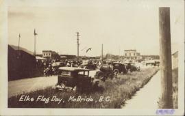
2011.3.1.15
·
Item
·
5 January 1945
Part of North Coast & Central BC Postcard Collection
Photograph of several vehicles parked along a road. A large crowd is visible gathering in the background. Printed annotation on recto reads: "Elks Flag Day, McBride, B.C." Handwritten annotation on verso reads: "Jan. 5th 1945. Dear Dad, Am working in a lumber camp, advised by Prof. Johnson and Prof Casey. Altitude about 2,300. Think I will like it, if they don't make me work to[sic] heavy. the Climate and the grub is swell. Otherwise not so hot. Bye for now. Love Will." Postcard is addressed: "To: Mr. A.W. Hockin Big Valley, Alberta. From. W. Hockin c/o E.U. Lamming McBride, B.C."
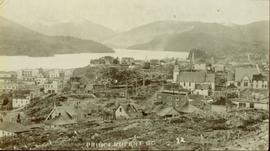
2011.3.3.56
·
Item
·
[ca. 1909-1930]
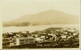
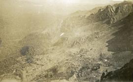
Part of North Coast & Central BC Postcard Collection
Elevated photograph of Prince Rupert taken from a hill. Residential and business buildings are visible. Background shows water and wooded hills. Printed annotation on recto reads: "Prince Rupert BC 22."
2011.3.3.65
·
Item
·
11 June 1915
Part of North Coast & Central BC Postcard Collection
Elevated photograph of Prince Rupert taken from a hill. Printed annotation on recto reads: "Prince Rupert BC McRae Bros." Handwritten annotation on verso reads: "11/June c/o PG Prince Rupert, B.C. Dear Rae[??], How about a letter. Love for all, Frank." Postcard is addressed to: "Miss R Boew. Bernie PG [illegible]." Postmark on verso reads: "Prince Rupert BC Jun 11 1 PM 1915."
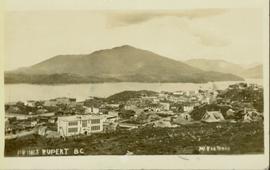
2011.3.3.66
·
Item
·
[ca. 1909-1930]
Part of North Coast & Central BC Postcard Collection
Elevated photograph of Prince Rupert taken from a hill. Printed annotation on recto reads: "Prince Rupert BC W.W.W." Handwritten annotation on verso reads: "2402 Cork Street."
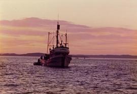
2009.6.13.49.0246
·
Item
·
[between 1974 and 1979]
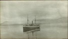
Part of The Honourable Iona Campagnolo fonds
Photograph depicts the El Dorado fishing boat off the coast of British Columbia, possibly near Haida Gwaii.
2009.7.1.135
·
Item
·
[ca. 1878 - ca. 1920]
Part of Archdeacon W. H. Collison fonds
Forest and hills on opposite shore in background.

2009.7.1.048
·
Item
·
[ca. 1930?]
Part of Archdeacon W. H. Collison fonds
Photograph depicts a large totem pole next to groomed dirt paths. Power poles and river visible in background.
Handwritten annotation on verso reads: "Edenshaw pole in park at Prince Rupert."
2009.7.1.067
·
Item
·
[ca. 1873 - ca. 1920]
Part of Archdeacon W. H. Collison fonds
Photograph depicts town buildings on opposite shore. Beach and dock can be seen in foreground.
Handwritten annotation on verso reads: "Chapter XXII, No 1. Eastern Section of Port Simpson as christianized."

2000.1.1.3.24.05
·
Item
·
[ca. 1955]
Part of Cassiar Asbestos Corporation Ltd. fonds
Photograph depicts unidentified individual and cars on street in foreground, snow banks, trees, and power poles on either side. Buildings can be seen on far right, mountains visible in background. Handwritten annotation on recto of photograph: "townsite Looking East".
2014.10.1.287
·
Item
·
1913
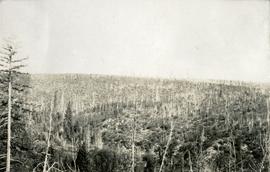
Part of Arthur Holland Land Surveying Collection
Photograph depicts a rocky, mountain slope.
2014.10.1.283
·
Item
·
1913
Part of Arthur Holland Land Surveying Collection
Photograph depicts a rocky, mountain slope.
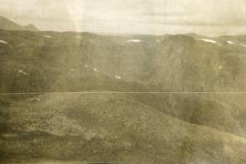
2014.10.1.330
·
Item
·
1914
Part of Arthur Holland Land Surveying Collection
Photograph depicts a view from a high ridge looking over vast forest.

2012.13.1.124.22
·
Item
·
May 1976
Part of J. Kent Sedgwick fonds
Image depicts an earth flow north of Stone Creek, B.C.

2012.13.1.124.21
·
Item
·
May 1976
Part of J. Kent Sedgwick fonds
Image depicts an earth flow north of Stone Creek, B.C.
2009.7.1.142
·
Item
·
[ca. 1878 - ca. 1920]
Part of Archdeacon W. H. Collison fonds
Hills on opposite shore in background.
Handwritten annotation on verso reads: "Early steamship off mouth of Nass River".
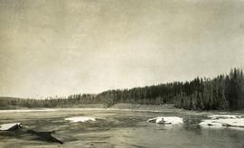
2014.10.1.097
·
Item
·
1910
Part of Arthur Holland Land Surveying Collection
Photograph depicts open river waters with some patches of ice on the river shore. There are riverbanks and trees in the background.

2000.1.1.3.24.02
·
Item
·
Septmeber 1954
Part of Cassiar Asbestos Corporation Ltd. fonds
Photograph depicts wood houses behind stand of trees in Cassiar valley. Truck, power poles, and road in foreground, mountains in background. Typed caption below photo in original duotang album: "Two Bedroom Pan-Abode Houses - Cassiar Townsite". Handwritten annotation on verso: "Sept 1954".

2010.13.12
·
Item
·
[20 April 1913?]
Part of Prince George Historical Photograph Collection
Early spring landscape with roadbed and track in foreground, river in midground, and hill in background.
Handwritten annotation on recto: “PRINCE GEORGE 4-20-13”.

2012.13.1.87.157
·
Item
·
[between 1975 and 1995]
Part of J. Kent Sedgwick fonds
Image depicts Eaglet Lake in the winter taken from Giscome, B.C. Map coordinates 54°04'20.9"N 122°21'53.1"W

2012.13.1.89.095
·
Item
·
[1980?]
Part of J. Kent Sedgwick fonds
Image depicts the creek flowing into Eaglet Lake. A grey area of hill on the right side of the image appears to be the Giscome Quarry. Map coordinates 54°04'26.2"N 122°22'04.3"W

2012.13.1.72.24
·
Item
·
July 1981
Part of J. Kent Sedgwick fonds
Image depicts an eastern view over Eaglet Lake.

2012.13.1.72.23
·
Item
·
July 1981
Part of J. Kent Sedgwick fonds
Image depicts the site of Giscome's first quarry, with Eaglet Lake located in the foreground.

2012.13.1.72.20
·
Item
·
July 1981
Part of J. Kent Sedgwick fonds
Image depicts the site of Giscome's first quarry, with a train passing by and Eaglet Lake located in the foreground.

2012.13.1.87.082
·
Item
·
[between 1975 and 1995]
Part of J. Kent Sedgwick fonds
Image depicts a lake at an uncertain location, likely Eaglet Lake.

2012.13.1.72.19
·
Item
·
July 1981
Part of J. Kent Sedgwick fonds
Image depicts Eaglet Lake, north-east of Prince George, B.C.

2009.7.1.173
·
Item
·
[ca. 1900]
Part of Archdeacon W. H. Collison fonds
Totem pole stands alone against a mountainous background.

2011.12.28
·
Item
·
[ca. September 1950- June 1951]
Part of Giscome, BC Historical Photograph collection
Shoreline perspective of Eagle Lake. Handwritten annotation in pen on verso reads: “This is Eagle Lake. It is about 2 blks [sic] away.”

2011.12.27
·
Item
·
[ca. September 1950- June 1951]
Part of Giscome, BC Historical Photograph collection
Shoreline perspective of Eagle Lake. Handwritten annotation in pen on verso reads: “Eagle Lake from the C.N.R. railway tracks.”

2011.12.32
·
Item
·
[ca. September 1950- June 1951]
Part of Giscome, BC Historical Photograph collection
Overview of sawmill situated in valley. Finished lumber visible in distance.

2012.13.1.50.138
·
Item
·
2006
Part of J. Kent Sedgwick fonds
Image depicts the Dunlevy Creek area somewhere near Dawson Creek, B.C. The slide is simply labelled "Dunlevy irrigation" for uncertain reasons.

2012.13.1.50.137
·
Item
·
2006
Part of J. Kent Sedgwick fonds
Image depicts the Dunlevy Creek area somewhere near Dawson Creek, B.C. The slide is simply labelled "Dunlevy irrigation" for uncertain reasons.

2000.1.1.3.18.001
·
Item
·
1953
Part of Cassiar Asbestos Corporation Ltd. fonds
Photograph depicts red truck dumping waste at what is believed to be the tailings pile at the Cassiar plant. Small building and unidentified individual in bottom left foreground, valley and mountains in background. Photo caption next to printed copy of image in 1953 Annual Report: "Stockpile of 80,000 tons of Ore at Mill."
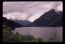
2012.13.1.54.27
·
Item
·
July 1977
Part of J. Kent Sedgwick fonds
Image depicts a view of Duffey Lake Provincial Park, looking west over Duffey Lake.
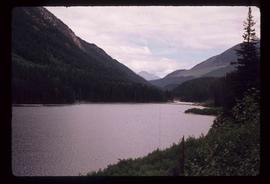
2012.13.1.54.28
·
Item
·
July 1977
Part of J. Kent Sedgwick fonds
Image depicts a view of Duffey Lake Provincial Park, looking east over Duffey Lake.

2012.13.1.50.055
·
Item
·
1978
Part of J. Kent Sedgwick fonds
Image depicts a large flock of ducks in a field full of water at an unknown location.

2014.10.1.104
·
Item
·
1910
Part of Arthur Holland Land Surveying Collection
Photograph depicts a tarp spread out on the grass, two men sit nearby the tarp. There is a canvas tent in the background with a man standing beside it. Behind the tent is a low hill with a fence bordering the top of the hill. There are blankets drying on the fence.

2000.1.1.3.18.004
·
Item
·
September 1954
Part of Cassiar Asbestos Corporation Ltd. fonds
Photograph depicts large dry rock storage building in foreground on right, mill on left behind tailings pile, and dryer building in centre behind conveyor belt connecting mill to dry rock storage. A cloud can be seen rising from plantsite. Trees and Troutline Creek cross foreground, mine valley and mountains visible in background. Stamped annotation on recto of photograph: "ANSCO PRINTON Munshaw Colour Service Ltd. MAR 10 1955".

2000.1.1.3.18.003
·
Item
·
September 1954
Part of Cassiar Asbestos Corporation Ltd. fonds
Photograph depicts large dry rock storage building in foreground on left, mill in background, dryer building in right midground. Miscellaneous supplies in far right foreground, mountains visible in background. Handwritten annotation on verso of photograph: "Sept 1954". This photograph was originally stored inside duotang labeled "CASSIAR ASBESTOS CORPORATION LIMITED PHOTOGRAPHS 1954"; photo caption beneath this image: "40,000 Ton Dry Storage Building / Mill / Dryer Building".

2000.1.1.3.18.002
·
Item
·
1953
Part of Cassiar Asbestos Corporation Ltd. fonds
Photograph depicts large dry rock storage building on left, mill in background, dryer building on far right. Road and power poles cross foreground, mountains stand in background. Photo caption next to printed copy of image in 1953 Annual Report: "Completed dry rock storage and dryer buildings."

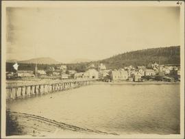
2009.7.1.053
·
Item
·
[ca. 1915?]
Part of Archdeacon W. H. Collison fonds
Photograph depicts buildings visible through clearing in trees. Water crosses foreground, hills visible in background.
Handwritten annotation on verso reads: "Dry dock / Prince Rupert B.C."
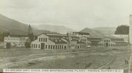
2011.3.3.59
·
Item
·
[ca. 1909-1930]
Part of North Coast & Central BC Postcard Collection
Ground level view of the dry dock in Prince Rupert, BC. Printed annotation on recto reads: "$3,000,000 Dry Dock and Shipbuilding Plant, Prince Rupert B.C." Handwritten annotation on verso reads: "With much love. To Many from Raha[??]."

2012.13.1.87.102
·
Item
·
[between 1975 and 1995]
Part of J. Kent Sedgwick fonds
Image depicts a driveway cordoned off by a red mesh material in Newlands, B.C. The address of the house is labelled 31951, and the name listed is "Fauchers." Map coordinates 54°06'47.8"N 122°08'22.4"W
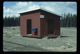
2012.13.1.62.02
·
Item
·
June 1978
Part of J. Kent Sedgwick fonds
Image depicts the Driftwood BCR station, possibly located near Driftwood Creek in the Driftwood Canyon Provincial Park east of Smithers, B.C.
2009.6.13.49.0178
·
Item
·
1978
Part of The Honourable Iona Campagnolo fonds
Photograph depicts the existing outlet at the proposed site for a hydro power project on Klemtu Lake.

2012.13.1.62.03
·
Item
·
June 1978
Part of J. Kent Sedgwick fonds
Image depicts a number of identical buildings and vehicles at "Driftwood Creek" in the Driftwood Canyon Provincial Park.
2009.6.13.49.0179
·
Item
·
1978
Part of The Honourable Iona Campagnolo fonds
Photograph depicts the existing outlet at the proposed site for a hydro power project on Klemtu Lake.