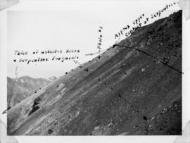
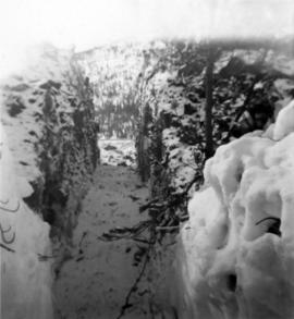
Photograph depicts flat area mostly covered in snow. Corresponding note on accompanying photo description page: "11. Indicates snow conditions in the cirque. Taken from near first switchback."
Photograph depicts mountain side, semi-covered in snow, trees in foreground. Corresponding note on accompanying photo description page: "9. Shows snow conditions in second gully north of talus deposit. Same condition here but high crown can be seen [see item 2000.1.1.2.228]."
Photograph depicts mountain side, semi-covered in snow. Snowbank in foreground. Corresponding note on accompanying photo description page: "8. Shows snow conditions in gully just north of talus deposit on south slope. Note considerable snow still above road. Estimated depth of snow here to be from 10 to 20 feet [see also item 2000.1.1.2.229]."
Photograph depicts man standing on dirt road. Snowbank to right of man is almost shoulder-height and disappears as road continues. Corresponding note on accompanying photo description page: "12. Indicates snow along the mountain road."
Photograph depicts snowy mountaintop, wooden shelter and truck in foreground. Corresponding note on accompanying photo description page: "Pictures taken July 2nd, 1952. 1. Picture taken from campsite showing snow on talus."
Photograph depicts high snow bank on right, side of tractor plow on left. Mountainside in background. Corresponding note on accompanying photo description page: "3. Plowing snow on road to mine. This location is just past the Upper Camp. Our TD-14 tractor to left."
Photograph depicts a cleared path through the snow and trees, mountain in background. Wood box and post semi-visible in foreground. Handwritten annotation in blue ink on recto of photograph: "You will notice we have a little snow here."
Photograph depicts snowy, cleared area bordered by dirt piles. Stakes visible in mid ground, trees and mountainside in background. Corresponding note on accompanying photo description page: "3. Survey stakes on power house site. Snow piles in background."
Handwritten annotation below photo on page taped to photograph: "PHOTO #2: Looking N across talus slide of asbestos fibre and serpentine fragments." Handwritten annotation on verso of photograph in blue ink describing sections of photograph which have been pointed to or outlined: "Talus of asbestos fibre & serpentine fragments -->" "Photo #1 -->" "Approx upper contact of serpentine -->".
Photograph depicts track loader moving dirt in semi-cleared area. Trees and mountains in background.
Photograph depicts track loader moving dirt in cleared area. It is believed that the loader may have been excavating area for ore haul truck dump (see item 2000.1.1.2.222). Trees and mountains in background.
Photograph was taken facing down a narrow, snowy trench, mountain base visible at end. Corresponding note on accompanying photo description page: "1. Trench through snow banks at mill site. We had to dig these trenches to facilitate surveying the mill foundations."
Image depicts Manson Creek, B.C.
Image depicts a man and his family filling up their truck with gas at Manson Creek, B.C.
Image depicts the gas station at Manson Creek, B.C.
Image depicts a creek with a half collapsed shack in the background somewhere in Manson Creek. The slide is labelled "Manson workings."
Image depicts the road to Manson Creek, B.C.
Photograph of the Prince Rupert wharf. Many vessels are docked next to small buildings along the water. Annotation on recto reads: "Prince Rupert BC."
Footage from a small plane overlooking the landscape of what is believed to be either the Bella Coola Valley, Tweedsmuir Provincial Park, Rainbow Mountains, or Chilcotin area.
Footage of hunting party setting up camp in the high country of the mountains. There is a herd of caribou and footage of caribou trophy kill. There is filming of two marmots and additional recordings of camp cooking and socializing.
The film ends with the hunters entering the plane again and returning to their original camp, believed to be Nimpo lake.
Film begins with short introduction of girl pointing to a map and drawing a line to where the men will be hunting.
Footage from a small plane overlooking the landscape of what is believed to be either the Bella Coola Valley, Tweedsmuir Provincial Park, Rainbow Mountains, or Chilcotin area.
Footage of hunting party setting up camp in the high country of the mountains. There is a herd of caribou and footage of caribou trophy kill. There is filming of two marmots and additional recordings of camp cooking and socializing.
The film ends with the hunters entering the plane again and returning to their original camp, believed to be Nimpo lake.
Map depicts the rivers, railways, and select lakes and towns located at Jasper Park between the northern boundary of the park and the townsite of Jasper. Part of the border between Alberta and British Columbia is visible on the west of the map.
Annotation on slide: "Marked-to-cut tree with old scar, Summit selection trial".
No annotation on slide.
Photograph depicts Mary John wearing flower print dress in cut field. Hay bales, trees, and fence in background.
Image depicts several houses in McBride, B.C. A mountain is visible in the background.
Image depicts a view of what is either the Rocky Mountains or possibly the Columbia Mountains from McBride, B.C.
Image depicts a view of what is either the Rocky Mountains or possibly the Columbia Mountains in the background of a small section of McBride, B.C.
Image depicts the McBride Hotel near the Mt. Robson Provincial Park.
Image depicts a view of the Herrick River in what is possibly McGregor Canyon; the slide is simply labelled "McG above Canyon."
Image depicts a view of the Herrick River in what is possibly McGregor Canyon; the slide is simply labelled "McG Canyon."
Image depicts a view of the Herrick River in what is possibly McGregor Canyon; the slide is simply labelled "McG above Canyon."
Image depicts a view of the Herrick River in what is possibly McGregor Canyon; the slide is simply labelled "McG Canyon - above Herrick."
Image depicts the McGregor River at an uncertain location.
Image depicts what is possibly the McGregor River.
Image depicts the McGregor River at an uncertain location.
Image depicts a bridge over the McGregor River. A sign in the image reads: "Danger. The river is not navigable for any type of boat. Down stream falls and rapids impassible!"
Image depicts a bridge over the McGregor River.
Image depicts the McGregor from the point of view of a bridge.
Forest cover map showing a crossing area of the McGregor River is annotated with a road and ferry crossing.
Image depicts a view of McGregor Valley from an uncertain location.
Image depicts a view of McGregor Valley.
Image depicts a view of the McGregor Valley.
Image depicts a view of McGregor Valley.