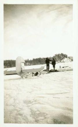
Two men stand on the ice of Pinchi Lake beside a small plane that appears to have crashed into the icy lake. Handwritten annotation in ink on the verso reads: "Plane on the ice at Pinchi".
Five unidentified miners pose for a photo. Logs and wood scraps in foreground, forest in background.
Printed annotation on recto of photograph: "PLACER MINING, ATLINTOD RIVER, ATLIN, B.C. A.C. HIRSHFELD NO. 753."
Photograph depicts two miners standing on either side of wooden sluicing trough in rocky area. Man on left pans for gold. Hills in background. Handwritten annotations on verso of photograph: "PLACER MINERS AT WORK INGINECA RIVER BC", "PHOTO WWW".
Photograph depicts an unidentified man mining in rocky area, trees and hills in background. Handwritten annotations on verso of photograph: "PLACER MINER WSHING FOR GOLD FINDLAY RIVER BC", "PHOTO WWW".
Photograph features a steep cliff across still water.
Handwritten annotation on verso reads: "Place of Scalps / Kincolith BC"
Photograph features a steep cliff across water, rocky shore in foreground.
Handwritten annotation on verso reads: "Up the 'Big Creek' at Kincolith B.C. Rock face called 'the place of echoes' by the Indian people."
Image depicts an unknown individual at the Place Glacier.
Image depicts the Place Glacier.
Image depicts two unknown individuals at the Place Glacier.
Image depicts the Place Glacier. There are two unknown individuals present.
Image depicts the Place Glacier.
Image depicts the Place Glacier. There are two unknown individuals present.
Image depicts the mostly frozen Place Creek Falls.
Photograph depicts a portion of the Cassiar pit in right foreground. Crushing plant visible to left of pit, West peak visible in right background. Mountain range can be seen in distance.
Photograph depicts a portion of the pit in foreground at the Cassiar mine. Crushing plant visible in centre below base of West peak. Footwall road in midground, mine valley in background. Building near trucks at top of pit was called the "shifter shack," where crews were relieved or dropped off for work.
Photograph taken at Terrace Gardens.
Image depicts a pipeline at Shelley, B.C.
Photograph is one of 13 images printed from digital format on a CD-R featuring members of a group referred to as 'Terracites' (see item 2009.6.1.697) pictured in the gardens; see also items 2009.6.1.698 - 2009.6.1.710.
Image depicts Pineview on Buckhorn Lake Road, Prince George, B.C.
Image depicts what is either the Peace or Kiskatinaw River in Pine Valley, B.C.
Photograph depicts Pine River winding between forested hillsides. Several islands covered with trees are located in the middle of Pine River. The river leads to Kinuseo Falls also known as Kinoosao Falls.
Image depicts a view of Pine Pass.
Image depicts an unidentified individual standing near a drop-off in the Pine Pass between Alberta and British Columbia. The sign behind the individual reads: "Pine Pass - 2,868 FT. Here the great barrier of the Rock Mountains is breached by the lowest highway pass. Once the remote route of the trapper, it now links the commerce of the north and markets of the south. The John Hart Highway was completed in 1952 and followed by the P.G.E. in 1958. Gas and oil lines also take advantage of this convenient natural feature."
Image depicts a view of what is possibly the Pine Pass located near the Murray Ridge.
Photograph depicts the Pinchi Lake mercury mine as seen from the water. Some buildings appear to be under construction. Handwritten annotation on verso reads: "Pinchi Lake min (mercury).
Photograph depicts a two men standing on piles of whale bones at a whaling station. Annotation on verso of photograph states: "Pile of whale bones, Whaling station, Vancouver Is."
Image depicts a pile of dead trees in a forest somewhere on Haida Gwaii.
Photograph depicts a pile of cut evergreen trees leaning on one another within a forested landscape.
Photograph of a large pile driver working on the waterfront at the foot of a forested slope. Printed annotation on recto reads: 'Pile-driver working on Government Wharf Hughes #55."
Photograph depicts a large group of women, men, and children standing and sitting on grass. Stand of trees crosses midground, forest visible in background. Handwritten annotation on verso of photograph: "Picnic at Fort George (Central) 1920." Photograph believed to have been taken at current location of Spruceland Shopping Center.
Image depicts an unknown woman taking pictures. Nearby are the skeletal remains of an unknown animal. The location is somewhere near the upper Fraser Canyon.
This remote-sensing aerial photograph was taken by Lockwood Survey Corporation Ltd. under contract for the B.C. Forest Service. This historically important aerial photograph depicts the W.A.C. Bennett Dam and Williston Reservoir soon after its flooding in 1968.
The identification coding on these photographs can be interpreted as follows:
- The largest number on the leftmost side is the frame number for the photograph.
- The following code to the right in the format B) 69-53 is currently unknown, but may refer to an internal project number for the Lockwood Survey Corporation.
- The 6" may refer to the camera's focal length in inches.
- Next is "17,150 ASL" which is 17,150 feet Above Sea Level.
- Following is "152.52" which refers to the camera's focal length in millimeters, which equals 6 inches.
- The "W1307" may refer to the reel, but that is unconfirmed.
- "8 SEP 69" is the date the photo was taken.
This remote-sensing aerial photograph was taken by Lockwood Survey Corporation Ltd. under contract for the B.C. Forest Service. This historically important aerial photograph depicts the headwaters of Williston Reservoir soon after its creation in 1968 with the building of the W.A.C. Bennett Dam on the Peace River.
The identification coding on these photographs can be interpreted as follows:
- The largest number on the leftmost side is the frame number for the photograph.
- The following code to the right in the format B) 69-53 is currently unknown, but may refer to an internal project number for the Lockwood Survey Corporation.
- The 6" may refer to the camera's focal length in inches.
- Next is "17,150 ASL" which is 17,150 feet Above Sea Level.
- Following is "152.52" which refers to the camera's focal length in millimeters, which equals 6 inches.
- The "W1307" may refer to the reel, but that is unconfirmed.
- "8 SEP 69" is the date the photo was taken.
Image depicts a view of the south direction of the grade for the British Columbia Railway, which was formerly known as the Pacific Great Eastern until 1972. It is at an uncertain location, possibly near Woodpecker or Prince George.
Image depicts an aerial view of the Ahbau area somewhere near Prince George, B.C.
Image depicts an aerial view of areas that have been used for logging around Prince George, B.C.
Photograph depicts Pete Callao on horseback looking through binoculars in order to determine his course through a forested valley to Pine River. In the background the peak of a mountain is visible.
Photograph depicts Pete Callao using an axe to cut a trail through an area covered with windfall.
Photograph depicts Pete Callao (left) and Frank Dewing (right) napping under a spruce tree lean-to in a forest clearing.
Photograph depicts two men (possibly Pete Callao and Carrol Paul) standing with two saddled horses. In the background a mountain vista is visible.
Image depicts an individual walking on a path through a forest somewhere on Haida Gwaii.