Showing 39008 results

Archival description
21297 results with digital objects Show results with digital objects
Shoreline Petroglyphs
2009.7.1.174 · Item · [ca. 1925]
Part of Archdeacon W. H. Collison fonds

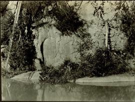
Petroglyphs featuring coppers painting onto a rock face next to a lake.

Handwritten annotation in pencil on verso reads: “As seen from the R.R. track. By Harlan I. Smith. 4 poles E of 92 mile or about 1 ½ meter E. of Tyce, B.C., Red Pictograph, Note: head above and to the right at the left of log top in shadow of cedar.” Stamped annotation on verso reads: “Department of Mines Geological Survey Photographic Division, January 21 1926” – in pen above this stamped date is written “7-10-1925”.

Shoreline housing
2009.10.1.71 · Item · [1927 or 1928]
Part of Fred Jeffery Photograph Collection

Photograph depicts a row of housing and buildings on the water's edge, boats are docked in the foreground, treed mountainside in the background. Handwritten annotation below photograph reads, "Indian section", suggesting that this housing was used by indigenous people.

Shoreline
Item · 4/1/1963
Part of Mary Fallis fonds

[Mountain vista from across lake] Strathcona Provincial Park, Vancouver Island, British Columbia

Shore Line at Airport
2012.13.1.124.02 · Item · 1970
Part of J. Kent Sedgwick fonds

Image depicts the shore line and surrounding land of a lake or river at an airport, possibly in Prince George, B.C.

Shore
2000.11.2.3 · Item · Aug-39
Part of Mary Fallis fonds

Item is a photo depicting a seashore in the foreground, a type of man-made berm (?) in the midground and an eroded cliff face in the background

2006.45.11 · Item · [ca. 1897]
Part of Historical North Coast Photograph Album

Shops stand along riverside boardwalk. Storefront sign for R. Cunningham & Sons visible. Many people stand and sit on boardwalk, and canoes and small boats float in water in foreground.

Handwritten photo captions beside image read: "R. Cunningham & Sons - Probably Port Essington", "NW coast canoe".

1996.8.1.374 · Item · Sept 1973
Part of Chander Suri fonds

2 blueprint plans attached together illustrating site plan, rezoning plan and site veiw of a commercial/residential building. Produced by Lee's Drafting and Design.

2013.6.36.1.014.20 · Item · 28 Apr. 1966
Part of David Davies Railway Collection

Photograph depicts the ship the "Princess Louise" under tow by the Vancouver tug "La Pointe", going through the First Narrows. Just before going through the current took her at 45 degrees to the course and for a moment it looked as if she might run aground.