Item
·
6/1/1984
Part of Mary Fallis fonds
21297 results with digital objects
Show results with digital objects
Item
·
6/1/1974
Part of Mary Fallis fonds
Item
·
8/1/1974
Part of Mary Fallis fonds
Item
·
11/1/1975
Part of Mary Fallis fonds
Item
·
10/1/1978
Part of Mary Fallis fonds
Item
·
6/1/1982
Part of Mary Fallis fonds
2001.26.1.2484
·
Item
Part of Northwood Pulp and Timber Ltd. fonds
This photo was taken at a public presentation co-sponsored by Canfor and Northwood introducing the company's "Prince George Air Quality Monitoring System".
Item
·
6/1/1980
Part of Mary Fallis fonds
2001.26.1.2491
·
Item
Part of Northwood Pulp and Timber Ltd. fonds
This photo was taken at a public presentation co-sponsored by Canfor and Northwood introducing the company's "Prince George Air Quality Monitoring System".
Item
·
7/1/1980
Part of Mary Fallis fonds
<i>Saxifraga</i>, Nunavut

2000.1.1.3.14.01
·
Item
·
1952
Part of Cassiar Asbestos Corporation Ltd. fonds
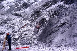
Photograph depicts two pick hammers laid in asbestos fibre. Annotations on note glued to recto of photograph: "ASBESTOS"; "Detail view of asbestos talus. Early test pit near top of showing. Western slope." Areas of image have been labeled "A" and "B". Photo caption under printed copy of image in 1952 Annual Report: "A - Asbestos fibre partially opened by frost action. B - Serpentine rock originally containing the asbestos fibre."
2013.6.36.1.103.09
·
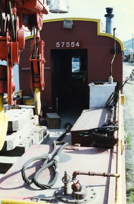
Item
·
[July 1997]
Part of David Davies Railway Collection
Photograph depicts a spare crane and an idler car.
2013.6.36.1.103.07
·
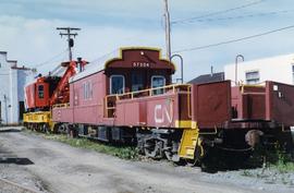
Item
·
[July 1997]
Part of David Davies Railway Collection
Photograph depicts a spare crane and an idler car.
2013.6.36.1.103.10
·
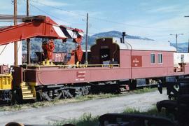
Item
·
[July 1997]
Part of David Davies Railway Collection
Photograph depicts a spare crane and an idler car.
2013.6.36.1.103.08
·
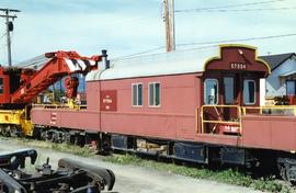
Item
·
[July 1997]
Part of David Davies Railway Collection
Photograph depicts a spare crane and an idler car.
2013.6.36.1.103.12
·
Item
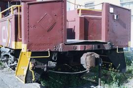
·
[July 1997]
Part of David Davies Railway Collection
Photograph depicts a spare crane and an idler car. Visible are the details of the rear end of the idle car.
2013.6.36.1.093.06
·
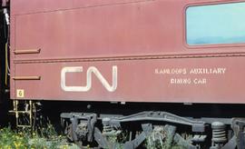
Item
·
Nov. 1993
Part of David Davies Railway Collection
Photograph depicts details of a CN derailment that occurred in Kamloops.
2013.6.36.1.103.05
·
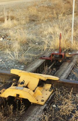
Item
·
[July 1997]
Part of David Davies Railway Collection
Photograph depicts the details of 3 axle trucks and car steps.

2013.6.36.1.108.03
·
Item
·
9 Apr. 2004
Part of David Davies Railway Collection
Photograph depicts details of a spout on a preserved water tank.
2000.10.5.5
·
Item
·
1972
Part of David G. Fish fonds
Consists of 1 report entitled "Assignment Report on Medical Education: Development of a Protocol for the Study of the Utilization of Doctors in Ceylon: WHO Project: Ceylon 0047," by Dr. David G. Fish, WHO Short-Term Consultant.
2007.1.25.4.06
·
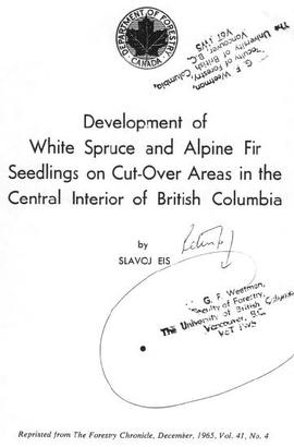
Item
·
1965
Part of Aleza Lake Research Forest fonds
Item is a photocopied version of Slavoj Eis' "Development of White Spruce and Alpine Fir Seedlings on Cut-Over Areas in the Central Interior of British Columbia" reprinted from The Forestry Chronicle, December 1965, Vol. 41, No. 4.
1996.8.1.375
·
Item
·
May 1989
Part of Chander Suri fonds
A b&w plan drafted on a tracing paper illustrating subdivision of a region. McKenzie Drive, Braefoot Rd. are identified on the plan. Produced by Central Planning and Management Consulting LTD Prince George
1996.8.1.370
·
Item
·
May 1989
Part of Chander Suri fonds
A b&w plan drafted on tracing paper re subdivision of an unidentified region. Dawn View Cr., Gordon Head Road, Edgelow St. are identified on the plan. Produced by Central Planning and Management Consulting LTD. Prince George BC
1996.8.1.239
·
Item
·
16 Dec 1980
Part of Chander Suri fonds
4 b&w plans which represent development of an area outside of A.L.R. They are produced by Central Planning and Management Cons. LTD. Cariboo Highway, Woolrich farm, Stone Creek and Fraser River are identified on the plan.
1996.8.1.240
·
Item
·
16 Dec 1980
Part of Chander Suri fonds
A b&w plan represents development plan of an area outside of A.L.R. It is produced by Central Planning and Management Cons. LTD. Cariboo Highway, Woolrich farm, Stone Creek and Fraser River are identified on the plan.
1996.8.1.241
·
Item
·
20 March 1981
Part of Chander Suri fonds
Two plans: one colour and one B&w, represent development plan of an area. produced by Central Planning and Management Cons. LTD. Cariboo Highway, Woolrich farm, Stone Creek and Fraser River are identified on the plans.
2016.5.5.04
·
Item
·
1989
Part of Harry Coates fonds
Item is a map of Prince George Wood Preserving Ltd. Development Plan Forest Licence A27771 for the period of January 1, 1986 to January 1, 1991: Fraser Operating Area. Geographic features include the Fraser River.
1996.8.1.068
·
Item
Part of Chander Suri fonds
A b&w plan drafted on tracing paper illustrating residential/commercial areas, beach, and lake of an unidentified region.
2009.10.2.064
·
Item
·
[between 1923 and 1925]
Part of Fred Jeffery Photograph Collection
Photograph depicts stalks of devil club. Handwritten annotation below photograph reads, "devil club stalks".
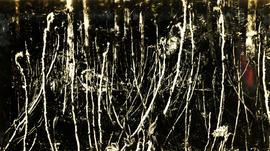
Item
·
10/1/1975
Part of Mary Fallis fonds
Wild grasses

2007.1.45.49.11
·
Item
·
June 1957
Part of Aleza Lake Research Forest fonds
Map of Timber Sale X72108 shows area to be scarified. Location is outside Prince George in the Upper Fraser area near Kenneth Creek.

2007.1.45.49.12
·
Item
·
June 1957
Part of Aleza Lake Research Forest fonds
Map of Timber Sale X72108 shows area to be scarified. Location is outside Prince George in the Upper Fraser area near Kenneth Creek.

2007.1.45.49.13
·
Item
·
June 1957
Part of Aleza Lake Research Forest fonds
Map of Timber Sale X72108 shows area to be scarified, as well as previously logged areas. Location is outside Prince George in the Upper Fraser area near Kenneth Creek.
Item
·
6/1/1978
Part of Mary Fallis fonds


2012.13.1.50.042
·
Item
·
1975
Part of J. Kent Sedgwick fonds
Image depicts an aerial view of Diamond Island, near Quesnel, B.C.
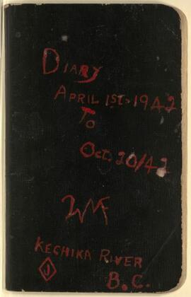
2023.8.01
·
Item
·
1942
Part of Willard Freer Diary Digital Collection
Summary of the diary of Willard Freer, April 1, 1942 to October 20, 1942:
- April 1-May 30, 1942: Trapping cabin along the Ingenika River
- May 30-June 16, 1942: In the Finlay River area, Freer sold furs to the HBC at Fort Grahame and helped portage supplied through Deserters Canyon for Del Miller and priest
- June 17-October 13, 1942: Employed with the United States Army in Northern BC, packing and outfitting for the survey crews of the Alaska Highway in the areas of Deserters Canyon, Fort Ware, Sifton Pass, and Fox Pass
- October 13-20, 1942: Journey to Skook Davidson's Diamond J Ranch
2023.8.06
·
Item
·
1946-1947
Part of Willard Freer Diary Digital Collection
Summary of the diary of Willard Freer, April 1, 1946 to September 30, 1947:
- March 27-April 15, 1946: Fort St. James, working with Hendry Kinniburgh
- April 15-May 3, 1946: Took the Greyhound bus from Prince George to southern BC to visit family (Keremeos, Penticton, Cawston)
- May 3-5, 1946: Travelled with family to Wenatchee, Washington to see a flower show
- May 6-11, 1946: Returned with family to Cawston, BC
- May 12-14, 1946: Return trip north to Fort St. James on the Greyhound bus via Keremeos, Ashcroft, Quesnel, and Prince George
- May 15-28, 1946: Preparing for summer work in Fort St. James
- May 28-September 4, 1946: Departed from Fort St. James for employment with Emil Bronlund and the Consolidated Mining and Smelting Co., packing through the Omineca District up to Thutade Lake
- September 9-October 25, 1946: Return trip to Diamond J Ranch
- October 26, 1946-May 27, 1947: Diamond J Ranch
- May 27-June 17, 1947: Travel to the British Columbia-Yukon Boundary Survey and preparations for work
- June 18-October 11, 1947: Head packer for the British Columbia-Yukon Boundary Survey
2023.8.03
·
Item
·
1944
Part of Willard Freer Diary Digital Collection
Summary of the diary of Willard Freer, January 1, 1944 to September 30, 1944:
- January 1-May 27, 1944: Diamond J Ranch
- May 27-June 6, 1944: Travel to Lower Post
- June 6-18, 1944: Waiting for C.H. Ney, land surveyor for the Dominion Geodetic Survey
- June 19-August 28, 1944: Packing for the Dominion astrofix survey
- August 28-September 7, 1944: Lower Post
- September 7-24: Return trip to Diamond J Ranch
- September 28-[October 21], 1944: Fort Ware trip to pick up food and machinery left after the Bedaux expedition
2023.8.05
·
Item
·
1945-1946
Part of Willard Freer Diary Digital Collection
Summary of the diary of Willard Freer, July 1, 1945 to March 31, 1946:
- June 3-7, 1945: Trip to Thutade Lake as a packer for Emil Bronlund, mining engineer for Consolidated Mining and Smelting
- June 7-October 5, 1945: Thutade Lake
- October 5-12, 1945: Trip to Fort Ware
- October 14-26, 1945: Return trip to Diamond J Ranch
- October 27-December 31, 1945: Diamond J Ranch
- January 1-February 25, 1946: Diamond J Ranch
- February 25-March 3, 1946: Trip to Fort Ware
- March 3-13, 1946: Fort Ware
- March 13-26, 1946: Fort Ware to Fort St. James
- March 27-April 15, 1946: Fort St. James, working with Hendry Kinniburgh
2023.8.02
·
Item
·
1942-1943
Part of Willard Freer Diary Digital Collection
Summary of the diary of Willard Freer, October 1, 1942 to December 31, 1943:
- October 1-13, 1942: Employed with the United States Army in Northern BC, packing and outfitting for the survey crews of the Alaska Highway in the areas of Deserters Canyon, Fort Ware, Sifton Pass, and Fox Pass
- October 16-29, 1942: Journey to Kechika River and Skook Davidson's Diamond J Ranch
- October 30-December 31, 1942: Working and establishing residence at Skook Davidson's Diamond J Ranch
- January 1-May 19, 1943: Working at Diamond J Ranch with Craig Forfar
- May 19-30, 1943: Trip to Fort Ware
- May 30-June 30, 1943: At Fort Ware, preparing for packing BC Government triangulation survey trip to surveying location and waiting for Skook Davidson to arrive with horses purchased from Jim Beattie
- June 18-July 13, 1943: Travel to surveying location
- July 15-August 17, 1943: Taking care of case camp while survey crews in field
- August 17-26, 1943: All crews working together
- August 27-October 23, 1943: Return trips between Fort Ware and Diamond J Ranch
- October 23-December 31, 1943: Diamond J Ranch