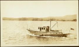
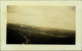
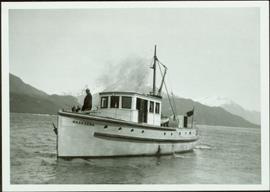
Handwritten annotation in pen on verso reads: "Dad [W.E. Collison] on ‘Naskeena’ – Prince Rupert Harboue en route to Nass River”.
Indian agency boat the “Naskeena” en route to its next destination. Handwritten annotation in pen on verso reads: “ ‘Naskeena’ en route”
Indian agency boat the “Naskeena” off Kitkatla B.C. W.E. Collison, Indian Agent standing at the stern.
Handwritten annotation in pen on verso reads: “‘Naskeena’ Gov. patrol boat off Kitkatla BC. W.E. Collison on stern.”
Unidentified deciduous tree in brilliant red autumnal foliage
Scotland trip
Photograph depicts a small cluster of buildings near the river bank.
Item consists of data and reports on The Fish and Fish Habitat Inventory Project on TFL 30. This project was designed to undertake a reconnaissance level stream inventory to describe watershed-wide fish distributions and habitat characteristics in all the streams within Tree Farm Licence #30.
Caption describing photograph: "T.F.L. #30 - View of McGregor Plateau with McGregor Mountains on horizon, Fraser River with Limestone Creek in foreground."
Caption describing photograph: "T.F.L. #30 - Typical stocking compatible with pre-scarification. C.P. 58."
Caption describing photograph: "T.F.L. #30 - Typical Spruce-Alpine Fir Stand."
Caption describing photograph: "T.F.L. #30 - Species Comparison - Typical first season leader (+/-3") on 2+1 White Spruce adjacent row to No. 1 [2007.1.30.2.126]"
Caption describing photograph: "T.F.L. #30 - Species Comparison - Typical first season leader (+/-12") on 2+1 Lodgepole Pine. Woodall Creek. High Site, outwash sands, after post-scarification."
Caption describing photograph: "T.F.L. #30 - Severely scalped area of 1965 post-scarification, no re-growth of brush, very little regeneration of S-B [Spruce-Balsam or Spruce-Alpine Fir] much of which killed by drought and/or frost heaving." A man kneels in the photograph for scale.
Caption describing photograph: "T.F.L. #30 - As in No. 7 [2007.1.30.2.123], illustrating poor growth of 2+0 planted at same time and on same site as No. 8 [2007.1.30.2.124], brush and grass removed for photo."
Caption describing photograph: "T.F.L. #30 - As in No. 7 [2007.1.30.2.123], illustrating competitive ability of 2+1 Spruce."
Caption describing photograph: "T.F.L. #30 - Re-growth of brush (ferns, grass, horsetail, Rubus). Old T.F.L. #28. Logged 1963, planted Spring 1965." A man stands in the photograph for scale.
Caption describing photograph: "T.F.L. #30 - Condition of 1965 pre-scarification on C.P. 58 (poor coverage), fair to good regeneration B-S [Alpine Fir-Spruce], still receptive."
Caption describing photograph: "T.F.L. #30 - Condition of 1965 post-scarification on C.P. 58. Severe brush invasion." A man stands in the photograph for scale.
Consists of a copy of an audio recording of Tex Hanson at Kleena Kleene, BC.
Photograph depicts a tethered pack horses in makeshift log stalls between Bella Coola and Anahim Lake during the WWII Polar Bear training exercise.
Photograph depicts a tethered pack horse between Bella Coola and Anahim Lake during the WWII Polar Bear training exercise.
Image depicts a vehicle on a gravel road somewhere near Tête Jaune Cache, B.C.
Image depicts a forest service cabin somewhere near Tête Jaune Cache, B.C.
Image depicts a collapsing shack somewhere near Tête Jaune Cache, B.C.
Beluga confinement and testing tank, Manitoba
This photo was taken at a public presentation co-sponsored by Canfor and Northwood introducing the company's "Prince George Air Quality Monitoring System".
Item is a photograph of a copy print, resulting in a low quality photographic reproduction. Reproduced as a print, slide, and a negative. Location of original photograph is unknown.
One paper which illustrates design criteria, lumber specifications and joints.
Handwritten photo album caption below this photo reads: "Teslin Lake and River, at 11 000 feet." Photograph depicts winding river below, mountain range in background.
Royal Canadian Air ForceImage depicts the Terzaghi Dam on the Bridge River, looking from the upstream (reservoir) side located near Bralorne, B.C. The water is Carpenter Lake.
Image depicts the Terzaghi Dam viewed from the downstream side near Bralorne B.C.
Photograph depicts Terry Nimmons on Gabriola Island.
Item is an audio cassette dubbed in 2001 from the original audio reel recorded for broadcast in September 1964 on CKPG Radio in Prince George.
Paradise Gardens greenhouse, near Hay River, Northwest Territories
Map depicts the topography around the township of Terrace, British Columbia. The Skeena River is noted, as well as the Coast Mountains and the Kitimat Ranges.
Photograph depicts a group of people from the Vancouver-based Terrace Support Group at a picnic table in Kitwanga.
Film is a Terrace promotional video with a short segment regarding UNBC.
Map depicts proposed industrial area outside of Terrace, British Columbia.
Image depicts a rail road bridge located somewhere near Terrace, B.C.
Image depicts a view of Terrace, B.C.
Publication contains an abridged version of the publication entitled "Termpol Assessment of the Navigational and Environmental Risks Associated with the Proposal of Kitimat Pipe Line Ltd. to Construct a Marine Oil Terminal at Kitimat, B.C." published by Transport Canada Coast Guard.
Photograph depicts the Pacific Terminus of the Trans Canada Highway in Tofino, B.C. on Vancouver Island.
Videotape contains footage of: 22-Feb-07 - Terahertz research; Bruce Sutherland; Matt Reid (Physics); Carrier Lumber
Item is a print of a photograph of tents and newly cleared land in Prince Rupert taken between 1906 and 1908.
Typed caption glued to album page directly below photograph reads: "69. Jordan's Addition on the Banks of the Nechac[k]o River." Photograph depicts three tents situated in an open field near the Nechako River. Photographer: Dominion Stock & Bond Corporation.