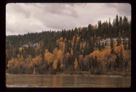
Image depicts a nature trail along the Nechako River at Island Cache looking west with the cutbanks in the background. Map coordinates 53°55'36.2"N 122°45'11.8"W
Image depicts some cacti somewhere near Soda Creek, B.C.
Slide depicts a camel and two llamas in an enclosed pasture. The photograph was taken in Kaleden, BC. Original slide index description: "Camel & Llamas in pasture, Kaleden."
Slide depicts a close up of a camel behind a fence. The photograph was taken in Kaleden, BC. Original slide index description: "Camel, Kaleden."
Image depicts an unknown individual eating in a camp somewhere in South Tweedsmuir Provincial Park.
Image depicts a campsite somewhere near Berg Lake.
Image depicts group of people at a camp somewhere in Mt. Robson Provincial Park.
Image depicts a camp on the shore of a lake in South Tweedsmuir Provincial Park. The man sitting in the bottom right corner is possibly Kent Sedgwick.
Image depicts a group of individuals at camp somewhere in Mt. Robson Provincial Park.
Image depicts a camp and what is likely Mt. Robson in the background.
Image depicts a camp of people with Mt. Robson and the Berg Glacier in the background.
Photograph depicts three men and dog in tent campsite. Cooking supplies and miscellaneous items in throughout, forest trees in background. Handwritten annotation on verso and recto of this photograph reads: "Camp on Upper end of Grand Canyon".
Photograph depicts a camp with three tents within a snowy forested landscape.
Photograph depicts pack horses at rest at a camp site situated on a grassy field. In the background a forested environment is visible.
Photograph depicts pack horses resting at a camp site situated on a grassy field. In the background a forested environment is visible.
Image depicts Kent Sedgwick (the man with a pipe in green) and an unknown individual sitting around a campfire somewhere in South Tweedsmuir Provincial Park.
Footage from a high point overlooking a mountainous landscape with clips of fish frying in a pan, men eating around the campfire and a fallen moose.
The location is believed to be the Rainbow mountains.
Image depicts a man at a campsite somewhere near Murray Ridge.
Image depicts Sue Sedgwick seated in a lawn chair near a campfire and several other unidentified individuals, as well as three dogs. The location is uncertain.
Photograph of a factory on the shoreline amidst a forested area. The factory is emitting steam or smoke and has a white exterior. Annotation on recto reads "Canadian Fish & Cold Storage Co. Prince Rupert BC."
Image depicts numerous piles of wood planks at the Canadian National Railway Yards in Prince George, B.C. The cutbanks are seen in the background.
Image depicts the BC Packers Ltd. cannery in Prince Rupert, B.C.
Photograph depicts cannery buildings on pilings with a body of water in the foreground and a deforested area behind the shoreline.
Photograph depicts cannery buildings on pilings with a body of water in the foreground and tree covered mountains in the background.
Photograph depicts cannery buildings on wooden pilings with a body of water in the foreground and a forested area in the background.
Photograph depicts a building under construction with wood planks on the dock in the foreground and a forested area in the background.
Photograph depicts a distance perspective of several cannery buildings with a body of water in the foreground and a mountain range in the background.
Photograph depicts a line of cannery fishing boats being towed across the water with the base of a mountain in the background.
Photograph depicts an empty canoe floating directly in front of small white tents on opposite shore. Forest trees in background.
Image depicts a house located somewhere in or near Canoe Creek.
Image depicts a view of Canoe Creek.
Photograph depicts a small pass through an island or peninsula on the Fraser River. Photo is believed to have been taken near Stone Creek, south of South Fort George. Annotation on verso of photograph reads: "FORT GEORGE CANYON. CANOE PASS. J. HEAY. PHOTO."
Riverboat floats in midground, canoes float by shore. Trees and hillside on opposite shore in background. Poor image quality.
Image depicts a view of the ridge above the Fraser River which forms the Grand Canyon, B.C.
Image depicts a car on a dirt road leading through a forest.
Photograph depicts car on water's edge at bottom of incline, possibly damaged, with back doors open. Trees and bushes in foreground.
Image depicts Bennett Lake near Carcross, Y.T.
Photograph taken at terrace gardens, Government House in Victoria, B.C.
Image depicts a log house at an uncertain location; the slide is simply labelled "Cariboo."
Image depicts the Cariboo Falls.
Image depicts the Cariboo Lake, with the roof of an old log cabin visible.
Image depicts the Cariboo River.
Image depicts the old, grown-over Cariboo Road at an uncertain location.
Image depicts the Cariboo Road south of Williams Lake.
Image depicts the Cariboo Road at Hat Creek Ranch, near Highway 99 on the way to Lillooet.
Image depicts the Cariboo Road in Soda Creek, B.C.
Footage of a large caribou bull in what is believed to be the Rainbow Mountains.
Footage of a caribou herd.
Probable locations of filming include the Chilcotin area, Rainbow Mountains, or Tweedsmuir Provincial Park.