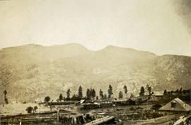
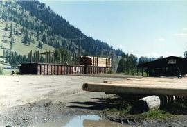
Photograph depicts a pole yard of Gorman Bros Ltd. Loading methods and quality were checked by CN inspectors in Kamloops, then on the main trans-continental line. These particular lines were destined for Ontario.
Photograph depicts a few scattered buildings and railway siding in the foreground, sparsely forested mountain in the background.
Photograph depicts a long wood frame building with a very tall totem pole in front. Handwritten annotation below photograph reads, "Hankedah, Nass River May 1927".
Photograph depicts where the Coquihalla Highway crossed over Coldwater River, 3 miles northwest of Brookmere. Trackage in the foreground was constructed in 1984/85 as its original routing interfered with the construction of the new highway built in 1985/86. This rebuilt rail bed had only been in use from 184/5 to May 1989.
Front view of tractor plow clearing snow-covered road site, trees on either side. Operator of plow is visible, but not identifiable.
Photograph depicts a plough found near Clulculz Lake, 45 miles west of Prince George. Its metal parts were made in the USA.
Annotation on slide: "Plot 3, Summit".
Annotation on slide: "Plot 3 uncut control plot, Summit Lake".
Photograph depicts a plateau leading into forested foothills and a snow-covered mountain range.
Image depicts an aerial view of a plateau near the Fraser River.
Photograph depicts plateau below summit between John Brown and Kitseucla creeks. Survey of 55th parallel.
Plaque reads: “1607, At Jamestown began: The expansion overseas of the English speaking peoples; The Commonwealth of Virginia; The United States of America; The British Commonwealth of Nations, 1957.”
Photograph depicts a plaque attached to the east side girder of bascule section of the Second Narrows railway bridge in Vancouver, BC
Handwritten photo album caption below this photo reads: “Fort St John Apron. F/Rideouts 'Norseman'^" Arrow is pointed at plane on far right with the number "2466" on its side and unidentified equipment below. Runway in foreground, approximately four military planes in background surrounded with unidentified people and equipment.
Royal Canadian Air ForceTwo men stand on the ice of Pinchi Lake beside a small plane that appears to have crashed into the icy lake. Handwritten annotation in ink on the verso reads: "Plane on the ice at Pinchi".
Handwritten caption above this photo reads: "Plane on Sumit Lake." Logs can be seen floating on water in foreground, as well as trees on opposite shore in background. The seaplane has the letters "CF-ATF" on its side.
Handwritten annotation on recto: "Plane carrying HG Perry 1930, - , at Ft. St. John, Peace River"
Five unidentified miners pose for a photo. Logs and wood scraps in foreground, forest in background.
Printed annotation on recto of photograph: "PLACER MINING, ATLINTOD RIVER, ATLIN, B.C. A.C. HIRSHFELD NO. 753."
Photo is adhered to paper backing, upon which handwritten annotation on recto reads: “Placer mining Hixon B.C. Hungry 30ies. This picture taken on top of hill across from Quesnel Quartz Mine maybe 800 ft west of Quartz taken approx 45 yrs ago (1933) 1978.12.19”
Two men stand below a large upright hose that is spraying a powerful stream of water against the side of a rocky hillside. Annotation on verso of photograph states: "Placer Mining Hixon (Hungry Thirties) This picture taken on top off Hill Across from Ques. Qarts. Maybe 800 Ft. west of Quarty There pictures taken approx 45 years ago Your friend(?) Box 156 Squamish B.C. Dec. 19/78"
Photograph depicts two miners standing on either side of wooden sluicing trough in rocky area. Man on left pans for gold. Hills in background. Handwritten annotations on verso of photograph: "PLACER MINERS AT WORK INGINECA RIVER BC", "PHOTO WWW".
Photograph depicts an unidentified man mining in rocky area, trees and hills in background. Handwritten annotations on verso of photograph: "PLACER MINER WSHING FOR GOLD FINDLAY RIVER BC", "PHOTO WWW".
Photograph features a steep cliff across still water.
Handwritten annotation on verso reads: "Place of Scalps / Kincolith BC"
Photograph features a steep cliff across water, rocky shore in foreground.
Handwritten annotation on verso reads: "Up the 'Big Creek' at Kincolith B.C. Rock face called 'the place of echoes' by the Indian people."
Image depicts an unknown individual at the Place Glacier.
Image depicts the Place Glacier.
Image depicts two unknown individuals at the Place Glacier.
Image depicts the Place Glacier. There are two unknown individuals present.
Image depicts the Place Glacier.
Image depicts the Place Glacier. There are two unknown individuals present.
Photographs depict two automobiles, ca. 1930, in Place de la Concorde, Paris, France.
Image depicts the mostly frozen Place Creek Falls.
Photograph depicts the CPR Pitt River swing bridge in an open position.
Photograph depicts a portion of the Cassiar pit in right foreground. Crushing plant visible to left of pit, West peak visible in right background. Mountain range can be seen in distance.