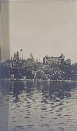
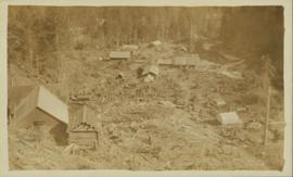
Photograph is a printed postcard depicting scattered small buildings and a tent. Trees have been removed from the area around the buildings and many stumps remain.
Photograph depicts three buildings and a water tower on top of a deforested hill with water in the foreground.
Photograph depicts buildings of the former Vancouver-Lansdale ferry. They appeared to now be used by Kingcome Navigation Co. as well as other businesses.
Photograph depicts small buildings sited on the north side of the tracks and just west of the Mission City CPR depot. They are all in use and well cared for.
Image depicts a row of buildings in Upper Fraser, B.C. with the store (titled "Paradise") with a Pepsi sign. Map coordinates 54°07'09.1"N 121°56'47.0"W
Image depicts several old buildings in a field, one of which has a caved-in roof, in Newlands, B.C. Map coordinates 54°06'28.2"N 122°12'01.0"W
The photograph depicts three buildings, white, beige, and blue at the Prince George airport. Annotations on the photograph describe the buildings as, "RCMP, airport terminal building, [and] small arms building."
The photograph depicts two buildings, one beige, the other white, at the Prince George airport.
The photograph depicts three buildings, white, beige, and blue at the Prince George airport.
Photograph depicts two large buildings across street in foreground, van visible on left.
Image depicts numerous buildings and a dock on the shore of Haida Gwaii, B.C..
Photograph of Prince Rupert businesses amidst clear cut stumps. Businesses include "Stewart and Mobley Groceries, Fruits and Produce." Printed annotation on recto reads: "Prince Rupert, B.C., Oct. 09."
Handwritten photo album caption below this photo reads: "D.O.T [Department of Transportation?] Bldgs & Garage, Whitehorse." Photograph depicts numerous buildings and a four-door garage on streets in Whitehorse. Dump trucks and other various vehicles surround garage. Road and gravel covered area crosses foreground.
Royal Canadian Air ForceImage depicts an unknown building under construction at the corner of 6th Avenue and Dominion Street in Prince George, B.C.
Image depicts an unknown building under construction at the corner of 6th Avenue and Dominion Street in Prince George, B.C.
The item is a photograph depicting a residential duplex house off the Cariboo Highway. It is one of three buildings that were relocated for the airport in 1957.
The item is a photograph depicting a residential duplex house off the Cariboo Highway. It is one of three buildings that were relocated for the airport in 1957
The item is a photograph depicting a residential duplex house off the Cariboo Highway.
The item is a 35 mm photograph depicting a stucco duplex on the Cariboo Highway.
The item is a photograph depicting a residential duplex house off the Cariboo Highway. It is one of three buildings that were relocated for the airport in 1957.
The item is a photograph depicting a white residential house off the Cariboo Highway.
The item is a 35 mm photograph depicting a stucco duplex on the Cariboo Highway.
The item is a photograph depicting a residential duplex house off the Cariboo Highway. It is one of three buildings that were relocated for the airport in 1957.
The item is a photograph depicting a residential duplex house off the Cariboo Highway.
The item is a 35 mm photograph depicting a stucco duplex on the Cariboo Highway.
The item is a photograph depicting a residential duplex house off the Cariboo Highway.
The item is a 35 mm slide photograph depicting a residential duplex house off the Cariboo Highway. It is one of three buildings that were relocated for the airport in 1957.
The item is a 35 mm photograph depicting a stucco duplex on the Cariboo Highway.
Image depicts a vehicle parked beside a small, wooden house in Upper Fraser, B.C. Map coordinates 54°07'05.7"N 121°56'38.9"W
Photograph depicts the Buckingham Apartments at 925 Cardero St.and Barclay St. in Vancouver, B.C.
Photograph depicts the Buckingham Apartments at 925 Cardero St. in Vancouver, B.C. after a snowfall. The view is looking south and depicts Barclay St. crossing in the foreground.
Photograph depicts a round bucket attached to the main hook line of a crane and suspended over building framework in crusher construction site (crane not visible in image). Men stand around the bucket on high level of crusher building. A dirt road and long building believed to be housing conveyor "B" can be seen in background.
Photograph depicts a round bucket attached to the main hook line of a crane (crane not visible in image) suspended over building framework in crusher construction site. Four construction workers stand around the bucket. Two men can be seen on roof of long building in background believed to be the section of the crusher building which housed conveyor B. Dirt road crosses midground.
Photograph depicts Buchanan Benson Real Estate and Insurance at 1276 4th Avenue.
Photograph of the front of Brown's General Store. Handwritten annotation in pen on verso reads: “Brown’s General Store. The wheelbarrow is for bringing the groceries and mail over from the train. Also if you buy a great quantity of things you wheel it home and then bring back the barrow (Taken on Sunday).”
Grassy area in foreground, trees and fence in background.
Handwritten annotation on verso reads: “House for Trudeau + Margaret, Q.C.I., Tlell”.
The photograph depicts a brown house in a forest outside of Finmoore, B.C. There is plastic pink flamingo in the yard. The photograph is taken in the autumn. Annotation on reverse side of photograph states, "Finmoore fall 2009."
Photograph depicts British Navy cottages (styled after cottages in the U.K.) in Esquimalt. Built when Dockyard was operated by the Imperial Navy.
Image depicts an aerial view of the BC Rail, in Prince George, B.C. It is now known as CN Rail.
Image depicts the entrance to a mine with an unknown individual present. It is possibly the entrance to the closed Britannia Mine in the Howe Sound Region.
Image depicts a number of old buildings, possibly located at the closed Britannia Mine.
Image depicts an old building, possibly located at the closed Britannia Mine.
Image depicts a piece of industrial machinery, possibly located at the closed Britannia Mine. Two unknown individuals are also present in the image.
Image depicts a conveyor belt, possibly located inside one of the old buildings at what is possibly the closed Britannia Mine.
Image depicts the inside of a mine with an unknown individual present. It is possibly the inside of the closed Britannia Mine.
Photograph depicts the Britannia Copper Mine in Howe Sound. The view is looking southeast.
Photograph depicts group of three at stone steps in courtyard at the University of Northern British Columbia, in Prince George, B.C. Photo taken on the day Moran received an Honourary Law Degree. Left to right: Bob Harkins, Bridget Moran, unknown.