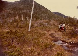
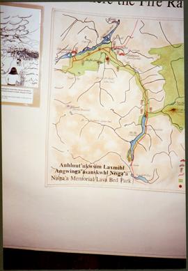
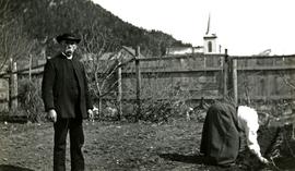
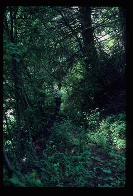
Image depicts an individual, possibly Kent Sedgwick, standing on a trail through a forest somewhere in or around Seton Portage, B.C.
Image depicts an unidentified man lighting a fire somewhere in South Tweedsmuir Provincial Park.
Photograph depicts a man with a helicopter at the location of the proposed powerhouse on Klemtu Lake.
Photograph depicts a man kneeling by row of trout between two small logs on grassy bank of a water's shore. What appears to be the vertical handle of a knife is foregrounded at bottom of image. Handwritten caption below this photo reads: "Trout Fishing."
Handwritten annotation below photo on page taped to photograph: "PHOTO #3 Showing approx. area covered by Asbestos - serpentine float". The approximate area has been outlined in blue ink on verso of photograph. Photo taken from lower level in valley, trees in foreground, outcrop visible in distance.
Photograph depicts mountain side mostly covered in snow. Corresponding note on accompanying photo description page: "10. Snow on mountain slope above road between where mountain road starts and the first switchback. This snow will melt and the water must still pass over or along road."
Photograph depicts flat area mostly covered in snow. Corresponding note on accompanying photo description page: "11. Indicates snow conditions in the cirque. Taken from near first switchback."
Photograph depicts mountain side, semi-covered in snow, trees in foreground. Corresponding note on accompanying photo description page: "9. Shows snow conditions in second gully north of talus deposit. Same condition here but high crown can be seen [see item 2000.1.1.2.228]."
Photograph depicts mountain side, semi-covered in snow. Snowbank in foreground. Corresponding note on accompanying photo description page: "8. Shows snow conditions in gully just north of talus deposit on south slope. Note considerable snow still above road. Estimated depth of snow here to be from 10 to 20 feet [see also item 2000.1.1.2.229]."
Photograph depicts man standing on dirt road. Snowbank to right of man is almost shoulder-height and disappears as road continues. Corresponding note on accompanying photo description page: "12. Indicates snow along the mountain road."
Photograph depicts snowy mountaintop, wooden shelter and truck in foreground. Corresponding note on accompanying photo description page: "Pictures taken July 2nd, 1952. 1. Picture taken from campsite showing snow on talus."
Photograph depicts a cleared path through the snow and trees, mountain in background. Wood box and post semi-visible in foreground. Handwritten annotation in blue ink on recto of photograph: "You will notice we have a little snow here."
Image depicts Manson Creek, B.C.
Image depicts a man and his family filling up their truck with gas at Manson Creek, B.C.
Image depicts the gas station at Manson Creek, B.C.
Image depicts a creek with a half collapsed shack in the background somewhere in Manson Creek. The slide is labelled "Manson workings."
Image depicts the Omineca Museum in Manson Creek, B.C.
Image depicts the road to Manson Creek, B.C.
Photograph depicts colour map displayed in unknown area, second poster semi-visible on left. See item 2008.3.1.22.34 for image believed to depict lava bed.
Map depicts the rivers, railways, and select lakes and towns located at Jasper Park between the northern boundary of the park and the townsite of Jasper. Part of the border between Alberta and British Columbia is visible on the west of the map.
Buildings in foreground, waterscape in midground, trees and snowcapped mountains in background. Printed annotation on recto reads: “Marine and Fisheries Digby Island Prince Rupert B.C. McRae Bros”
Handwritten annotations read: "At rest, after a rough passage of two days and a night from Massett, Queen Charlotte's Islands by canoe - W.H. Collison and Mrs. Collison with Indians from Masset"; "Archdeacon Collison Indian Canoe & Crew. Return from Queen Charlotte's Islands, Haida & Tsimshian Crew [...?]" Archdeacon and Mrs. Collison sit in centre of canoe.
Photograph depicts Archdeacon William Henry Collison to left of wife Marion, who stands bent over garden on right. Church steeple visible behind wood fence in background. Hills can be seen in distance.
Handwritten annotation on verso reads: "Grandad & Grannie in garden at Kincolith".
Canoe with mast floats close to shore in foreground, mountains visible across river in background.
Handwritten annotation on verso reads: "Arch. W.H. Collison & wife with native friends en route up Skeena River."
Photograph depicts Marion and William Henry Collison standing on left with shovel, Bertha Collison on right, and young Muriel and Katherine Collison in centre with shovel (eldest daughters of W.E. Collison). Wood buildings cross midground, trees and hills visible in background.
Handwritten annotation on verso reads: "Garden at Kincolith / Grandad, Grannie / Mimi, Katie / Mother".
Group of five unidentified men stand on shore to right of large dugout canoe, handling their rifles. Forest and snow-capped mountains stand on opposite shore in background.
Handwritten annotation on verso reads: "Mrs Collison (wife of Arch. Collison in Canoe en route to Hazelton B.C."
Image depicts a row of houses in the village of Masset on Haida Gwaii.
Image depicts McBride, B.C.
Image depicts the All Saints Anglican Church in McBride, B.C. The slide labels it as having "moved to PG."
Image depicts a church somewhere in McBride, B.C. The sign in front possibly reads "St. Patrick's Church."
Image depicts the Elks Hall in McBride, B.C.
Image depicts a machine shop somewhere in McBride, B.C. The sign above the door reads "McBride Air Cooled Engine Services Ltd."
Image depicts a house somewhere in McBride, B.C.
Image depicts several houses in McBride, B.C. A mountain is visible in the background.
Image depicts an old house somewhere in McBride, B.C.
Image depicts a view of what is either the Rocky Mountains or possibly the Columbia Mountains from McBride, B.C.
Image depicts a view of what is either the Rocky Mountains or possibly the Columbia Mountains in the background of a small section of McBride, B.C.
Image depicts the CN Station in McBride, B.C.
Image depicts the rear-end of the CN Station in McBride, B.C.
Image depicts the McBride District Centennial Library.
Image depicts the McBride Hotel near the Mt. Robson Provincial Park.
Photograph depicts street in McBride, wood buildings and tent buildings on either side. Small businesses and restaurants line the left side of the street. Forest slash stands in newly cleared area in foreground. Railway tracks cross right foreground, hills visible in background. Annotation on verso of photograph reads: "MC.Bride, B.C.", handwritten on recto: "1914 [Bourchier?]"
Image depicts a view of the Herrick River in what is possibly McGregor Canyon; the slide is simply labelled "McG above Canyon."
Image depicts a view of the Herrick River in what is possibly McGregor Canyon; the slide is simply labelled "McG Canyon."
Image depicts a view of the Herrick River in what is possibly McGregor Canyon; the slide is simply labelled "McG above Canyon."