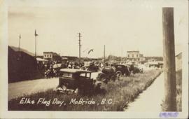
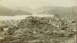
Print preview Close

Showing 3756 results

Archival description
3615 results with digital objects Show results with digital objects
Elks Flag Day, McBride, BC
2011.3.1.15 · Item · 5 January 1945
Part of North Coast & Central BC Postcard Collection

Photograph of several vehicles parked along a road. A large crowd is visible gathering in the background. Printed annotation on recto reads: "Elks Flag Day, McBride, B.C." Handwritten annotation on verso reads: "Jan. 5th 1945. Dear Dad, Am working in a lumber camp, advised by Prof. Johnson and Prof Casey. Altitude about 2,300. Think I will like it, if they don't make me work to[sic] heavy. the Climate and the grub is swell. Otherwise not so hot. Bye for now. Love Will." Postcard is addressed: "To: Mr. A.W. Hockin Big Valley, Alberta. From. W. Hockin c/o E.U. Lamming McBride, B.C."

Entrance to Squamish River
2013.6.36.1.003.089 · Item · Sept. 1965
Part of David Davies Railway Collection

Photograph depicts the entrance to the Squamish River at Squamish, looking upstream. The pier on the left belongs to the original logging railway, circa 1909-1925.

Eroding Rock Face?
2012.13.1.98.60 · Item · 1999
Part of J. Kent Sedgwick fonds

Image depicts what appears to be an eroding rock face. The slide itself is labelled "ash loger at top" for unknown reasons. Possibly located somewhere near Whitehorse, Y.T.

2012.13.1.121.07 · Item · July 1970
Part of J. Kent Sedgwick fonds

Image depicts an atmometer. According to the slide, it is being used for measuring the rate of water evaporation "from carborundum stone." The location is uncertain.

Examining a Rock
2012.13.1.91.38 · Item · 1979
Part of J. Kent Sedgwick fonds

Image depicts a group of individuals who appear to be examining a rock. It is possibly part of an educational trip.

Examining Rocks
2012.13.1.93.21 · Item · 1978
Part of J. Kent Sedgwick fonds

Image depicts three unidentified individuals examining rocks near a set of railway tracks at an uncertain location in the Peace River Region.

Farm
2012.13.1.50.067 · Item · 1978
Part of J. Kent Sedgwick fonds

Image depicts a farm on the west side of the Fraser, south of Quesnel, B.C.

Farm?
2012.13.1.50.111 · Item · 1980
Part of J. Kent Sedgwick fonds

Image depicts what appears to be a farm at an uncertain location.

Farm
2012.13.1.72.18 · Item · July 1981
Part of J. Kent Sedgwick fonds

Image depicts a farm at an uncertain location; possibly somewhere in the McGregor Valley.

Farm
2012.13.1.54.65 · Item · July 1980
Part of J. Kent Sedgwick fonds

Image depicts a farm at an uncertain location.

Fault?
2012.13.1.50.050 · Item · 1978
Part of J. Kent Sedgwick fonds

Image depicts an unknown individual standing next to what appears to be a fault at an unknown location.

Fault?
2012.13.1.50.054 · Item · 1978
Part of J. Kent Sedgwick fonds

Image depicts what appears to be a fault at an unknown location.

Felled Trees
2012.13.1.56.06 · Item · 1973
Part of J. Kent Sedgwick fonds

Image depicts a large number of felled trees, and an unknown individual standing on the path.

Fence
2012.13.1.12.18 · Item · Sep. 1983
Part of J. Kent Sedgwick fonds

Image depicts a fence, perhaps somewhere in the Chilcotin region.

Fence
2012.13.1.12.15 · Item · Dec. 1980
Part of J. Kent Sedgwick fonds

Image depicts a fence in the Blackwater River area in the Chilcotin.

Fence
2012.13.1.12.17 · Item · Sep. 1983
Part of J. Kent Sedgwick fonds

Image depicts a fence somewhere in Anahim Lake, B.C.

Fence
2012.13.1.12.16 · Item · Sep. 1983
Part of J. Kent Sedgwick fonds

Image depicts a fence somewhere in Anahim Lake, B.C.

Fence and Power Lines
2012.13.1.78.47 · Item · 1982
Part of J. Kent Sedgwick fonds

Image depicts a fence and power lines near the shore on Haida Gwaii. It is possibly a small community such as Masset.

Fenced Off Forest Area
2012.13.1.87.149 · Item · [between 1975 and 1995]
Part of J. Kent Sedgwick fonds

Image depicts two unidentified individuals standing outside a small, enclosed area somewhere in a forest. The location is uncertain.