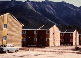
Photograph depicts four orange and brown two-story buildings speculated to be bunkhouse residences. Blue car in foreground, forest and mountains in background.
Photograph depicts an unidentified man walking in front of orange and brown two-story building speculated to be bunkhouse residences. Second unknown individual can be seen unloading car in left foreground. Trees and mountains visible in background.
Photograph depicts a Chevrolet pickup truck on highway to right of Mud Lake, at Km 632 on the Stewart-Cassiar Highway. Forest on hillside in background.
Street view photograph of several commercial buildings on an unidentified dirt road in Prince Rupert, BC. Foreground is primarily a shot of "Wallace's Dry Goods."
Photograph of a bridge along a rocky shoreline. Printed annotation reads: "Colloway Rapids Bridge Prince Rupert Highway W.W.W." Handwritten annotation on verso is heavily obscured by residual album paper and reads: "PO Box 777 Prince Rupert BC. [Illegible] Lal. This[??] is a piece of our new bridge which [obscured] neats our Island with the mainland. We have had picnics on the other side & [illegible] is open for [illegible] to [illegible]ve ours this side of the [obscured] our stuff to the little [obscured] patronize[??]. Mrs. [illegible] are back again in Rupert [obscured] Kamloops office closed down [obscured] was no chance of transfer. Have not."
Photograph depicts the sons and daughters of Marion and Archdeacon W.H. Collison, and one unidentified man. Buildings can be seen on shore in background.
Handwritten annotation on verso reads: "Collison family at camp (Portland Canal) Max, ?, Henry, Elsie, Arthur, Alice, Herbert".
Photograph depicts the sons and daughters of Marion and Archdeacon W.H. Collison sitting on the ground with food supplies at the top of a hill. Individuals believed to be (left to right): Arthur, Elsie, Herbert, Henry (in chef's hat), unknown, William, John Maxwell ('Max').
Handwritten annotation on verso reads: "Collison family on prospecting trip up Portland Canal."
Group can be seen in distance by canoe close to trees and cliff on opposite shore. Rocky shore of river in foreground.
Handwritten annotation on verso reads: " 'The Place of Echoes' The Big Creek at Kincolith. Dad, Jack, Joyce & Bob Stewart". Believed to be present in image are the son, grandson, and granddaughter of Archdeacon W.H. Collison, respectively: Rev. W.E. Collison, John (Jack) Macdonald and Joyce Collison.
Item is a hand drawn and coloured map by the City of Prince George Planning Department depicting the College Heights and southwest (Vanway) neighbourhood area existing land use in 1976.
Image depicts a collapsing shack somewhere in the Seton Portage area.
Collection of four photographs of the Prince Rupert dry dock. Two images are the finished dry dock buildings. One image is of construction. Printed annotation on recto reads: "Before Launching Canadian Scottish Dry Dock, Prince Rupert BC."
Collection of four photographs of the Prince Rupert dry dock. Printed annotation on recto reads: "Dry Dock and Ship Building Plant, Prince Rupert BC."
Captions below images on recto read: “H.M.C.S. Thiepval. Capt Beech.; In surf Recks and Fog. Wikelski Island; The Aeroplane; Major Stuart MacLaren, and party, at Prince Rupert. B.C.; British Around –the –World, Wrecked Aeroplane”.
Printed captions below images on recto read: “Souvenir of Prince Rupert BC; Prince Rupert June 1st, 1909; Prince Rupert Sept 1st, 1913; Public School; Water Front; City Hall; Haye Cove; Margaeto Fleet; Harbour Scene; SS Prince Marquitta at Prince Georg; Sunrise Prince Rupert Harbour; General Hospital; Gold Storage Place; Prince Rupert from Summit”.
Water level photograph of several small vessels gathered around a large cold storage building. Printed annotation on recto reads: "Cold Storage, Prince Rupert B.C. 66."
Item is a photograph of the coffer dam built to isolate the construction site for the W.A.C. Bennett Dam.
Photograph depicts a view from a water vessel looking toward an inlet and mountains near the shore.
Image depicts numerous trees in the coastal forest of Haida Gwaii, B.C.
Image depicts the coastal forests on the shores of Haida Gwaii, B.C.
Image depicts the coastal forests on the shores of Haida Gwaii, B.C. An unknown individual is crouching on the beach in the image.
Photograph depicts a dock on the left, water, low treed hills in the center of the photo and mountains in the distance.
Image depicts the coastline of Haida Gwaii, B.C.
Image depicts a view of the coast of Haida Gwaii.
Image depicts an aerial view of the coastline of Haida Gwaii, B.C.
Image depicts a view of the coast of Haida Gwaii.
Image depicts the coastline of Haida Gwaii, B.C.
Image depicts a view of the coast of Haida Gwaii.
Street view photograph of a large brick with a vehicle parked in front. Printed annotation on recto reads: "C.N.R. Station Prince George, B.C."
Photograph depicts a close-up of Alert Bay house posts adorned with First Nations carvings. Photographer’s stamp on verso: “W.E. Nicholson, 268 E. 10th, Vancouver 10, B.C.”
Photograph depicts a close-up of a totem pole behind a fence overlooking a wharf and a ship named Camosun. Photographer’s stamp on verso: “W.E. Nicholson, 268 E. 10th, Vancouver 10, B.C.”
Image depicts Upper Fraser residential area during demolition of town site. Map coordinates 54°06'51.6"N 121°56'26.3"W
Forest and hills on opposite shore in background.
Handwritten annotation on verso reads: "poling canoe up Nass River".
Close up photograph of a large residential building in a freshly clear cut area. To the right of the main building is the church and an unidentified commercial building. Annotation on recto reads: "Prince Rupert, BC 1660."
Image depicts a view of the scenery near Clinton, B.C.
Image depicts a climbing either up or down a rock face.
Image depicts a camper passing under an overhang as it drives along a narrow road near a cliff; located somewhere near Bralorne, B.C.
Image depicts a camper parked on the side of a narrow road along a cliff as another car approaches; located somewhere near Bralorne, B.C.
Photograph depicts opposite shore in background behind river, and close shore in foreground on right. Men can be seen standing and paddling on canoe in distance. Handwritten photo caption on verso and recto of this photograph reads: "On the Clearwater".
Photograph depicts opposite shore in midground behind river, tree-covered hills in background. Handwritten photo caption on verso and recto of this photograph reads: "On the Clearwater".
Photograph depicts a river, riverbank, forest and treed rolling hills.
Photograph depicts a scow with several men in the center of a river.
Image depicts a clearing at Island Cache.
Image depicts a highway, and a section of mountain in the background which is bare due to clear-cut logging. It is possibly somewhere near Prince George, B.C.
Image depicts a logging area, and a section of mountain in the background which is bare due to clear-cut logging. The slide is also labelled "logging show." It is possibly somewhere near Prince George, B.C.
Photograph depicts a man standing on a high ladder pouring grain from a sack to a tarp below. Sacks of grain in the foreground, field and trees in the background.