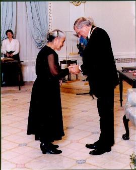
Photograph depicts Mary John shaking hands with unidentified man at official ceremony where she was awarded the Order of Canada for outstanding service to her community. Two unidentified woman stand in background in large ornately furnished room.
Close view of Mary John. Plant, couch, and window in background.
Photograph depicts temporary payroll clerk Mary Comper.
Photograph depicts one of the two Mars flying boats that were used as water bombers. Either "Hawaii Mars' or "Phillippine Mars."
No annotation on slide.
Annotation on slide: "Marked-to-cut tree with old scar, Summit selection trial".
Group of five unidentified men stand on shore to right of large dugout canoe, handling their rifles. Forest and snow-capped mountains stand on opposite shore in background.
Handwritten annotation on verso reads: "Mrs Collison (wife of Arch. Collison in Canoe en route to Hazelton B.C."
File consists of a portrait photograph of a personnel member of the Canadian Women's Army Corps. The woman depicted is believed to be Marion Christina Schenk, the elder sister of Bertha Schenk [Wood].
Photograph depicts Marion and William Henry Collison standing on left with shovel, Bertha Collison on right, and young Muriel and Katherine Collison in centre with shovel (eldest daughters of W.E. Collison). Wood buildings cross midground, trees and hills visible in background.
Handwritten annotation on verso reads: "Garden at Kincolith / Grandad, Grannie / Mimi, Katie / Mother".
Canoe with mast floats close to shore in foreground, mountains visible across river in background.
Handwritten annotation on verso reads: "Arch. W.H. Collison & wife with native friends en route up Skeena River."
Marion sits to left of husband Archdeacon William Henry, beside five small children. Muriel 'Mimi' Collison (daughter of W.E. Collison) stands on right holding a younger grandchild.
Handwritten annotation on verso reads: "Arch. WH Collison & Mrs Collison with grand-children at Kincolith".
Marion sits to left of husband Archdeacon William Henry, small boy in between. Young children sit and stand in foreground, Katherine 'Katy' and Muriel 'Mimi' stand in background (daughters of W.E. Collison). The group poses in front of a wood door, ivy on either side.
Handwritten annotation on verso reads: "Grand-dad (Arch. W.H. Collison) & Grannie with grandchildren at Kincolith".
Photograph depicts Archdeacon William Henry Collison to left of wife Marion, who stands bent over garden on right. Church steeple visible behind wood fence in background. Hills can be seen in distance.
Handwritten annotation on verso reads: "Grandad & Grannie in garden at Kincolith".
Handwritten annotations read: "At rest, after a rough passage of two days and a night from Massett, Queen Charlotte's Islands by canoe - W.H. Collison and Mrs. Collison with Indians from Masset"; "Archdeacon Collison Indian Canoe & Crew. Return from Queen Charlotte's Islands, Haida & Tsimshian Crew [...?]" Archdeacon and Mrs. Collison sit in centre of canoe.
Buildings in foreground, waterscape in midground, trees and snowcapped mountains in background. Printed annotation on recto reads: “Marine and Fisheries Digby Island Prince Rupert B.C. McRae Bros”
Margaret (nee Baxter) Lund stands in snowshoes wearing skirt, high socks, sweater, hat and gloves. Log fence crosses midground, power poles and unidentified building stand in background. Margaret is younger sister to Bob Baxter.
Handwritten annotation on verso reads: “Terrace B.C., July election campaign”.
Margaret and Gus Lund stand on road, arms linked. Wood structure believed to be the box of a truck stands behind them on left. Power poles and forest in background behind road.
Handwritten annotation at bottom reads: “To Margaret Main, Love Iona Campagnolo”.
Photograph depicts Margaret Hope, organizer of a 3 week tour. She was standing beside her husband's deluxe machine that was built from scratch. Taken on the CNR Okanagan line.
Street view of a large crowd of veterans marching down a street in Prince Rupert. Printed annotation on recto reads: "3." Handwritten annotation on verso reads: "Prince Rupert: Nov. 11. 1940. Main St."
Photograph of a small marching band parading down Second Avenue in Prince Rupert. A large crowd is gathered. Annotation on recto reads: "Photo by MacRae Bros Prince Rupert BC 2nd Ave Prince Rupert BC."
Photograph of a marching band performing down a wooden road. Spectators can be seen in the foreground and various businesses are in the background. Annotation on recto reads: "Prince Rupert BC."
Image depicts a marching band with numerous other unidentified individuals. One man is carrying a Canadian flag with the depiction of men in a boat and the words "Canada Sea-to-Sea" on it, and there is a mascot beside him that appears to be a chipmunk in an RCMP uniform.
Image depicts a marching band with numerous other unidentified individuals. One man is carrying a Canadian flag with the depiction of men in a boat and the words "Canada Sea-to-Sea" on it.
Map depicts the rivers, railways, and select lakes and towns located at Jasper Park between the northern boundary of the park and the townsite of Jasper. Part of the border between Alberta and British Columbia is visible on the west of the map.
Map reflects reserve boundary, roads, trails, 20 feet contour intervals, air photo centre, declination, swamps, and mile post at the Aleza Lake Forest Reserve.
Photograph depicts a map of the Prince George-Peace River district after the 1961 census.
Photograph depicts a map of the Prince George-Bulkley Valley district after the 1971 census.
Photograph depicts colour map displayed in unknown area, second poster semi-visible on left. See item 2008.3.1.22.34 for image believed to depict lava bed.
Image depicts a man holding up a board which appears to have maps of the Cottonwood Park on it.
Item is a photocopied map of the Aleza Lake area annotated to show transects.
Item is a reproduced map of Aleza Lake annotated to show a 1994 RFP study area.
Photograph of the Prince Rupert wharf. Many vessels are docked next to small buildings along the water. Annotation on recto reads: "Prince Rupert BC."
Image depicts the road to Manson Creek, B.C.
Image depicts the Omineca Museum in Manson Creek, B.C.
Image depicts a creek with a half collapsed shack in the background somewhere in Manson Creek. The slide is labelled "Manson workings."
Image depicts the gas station at Manson Creek, B.C.
Image depicts a man and his family filling up their truck with gas at Manson Creek, B.C.
Image depicts Manson Creek, B.C.
Photograph depicts two men in plant site, mountains in background. Corresponding note on accompanying photo description page: "Pictures taken July 3rd, 1952. 3. Quonset warehouse in background. Temporary set-up for circular saw in foreground."
Photograph depicts four unknown animals in distance on mountain slope, valley in background.
Photograph depicts a mill with scaffolding on the left side of the building. A second scaffolding structure is in the foreground with trees and mountains in background. Typed annotation taped to verso of page stapled to photographs: "View of mill building looking west."
Photograph depicts body of water in mountain valley, trees surrounding.