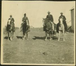
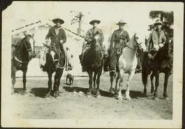
Officers are mounted on four horses in cleared area. Fifth horse stands on left, dog stands behind officers. Trees and white building visible in background. Handwritten annotation on recto of photograph: "Jas Tracey - Vanderhoof. A. Birch. Gilbert."
Officers are mounted on four horses in cleared area. Field and two buildings visible in background. Photograph may have been taken in Vanderhoof, B.C.
Photograph depicts Fort Steele in the Kootenays region of British Columbia.
Photograph depicts shay locomotive #115. It was running order, but not in steam on the day the photograph was taken. A rod locomotive was found in a shed towards the left. Rails of the spur found in the foreground that led to the shed.
Photograph depicts shay locomotive #115 in steam and with a working engine for the day. It was about to take on water.
Photograph depicts shay locomotive #115. It was running order, but not in steam on the day the photograph was taken. A rod locomotive was found in a shed towards the left, while the "Dunrobin" lay in disuse (but was still workable) in a shed on the rear right.
Image depicts a turbine on the back of an industrial vehicle, located somewhere in Fort St. John, B.C. The slide is labelled "Site one dam; turbine prop. (Russian.)"
Image depicts a turbine on the back of an industrial vehicle, located somewhere in Fort St. John, B.C.
Image depicts a turbine on a large industrial vehicle somewhere in or near Fort St. John, B.C.
Photograph depicts the early settlement of Fort George. The buildings to the left of the fence are believed to be owned by the Hudson's Bay Company. The land to the right of the fence belonged to the Fort George Reserve, the home of today's Lheidli T'enneh Band who relocated to a reserve at Shelley when this reserve was sold in 1912. Handwritten annotation on verso and recto of this photograph reads: "Fort George from opposite side of Fraser River".
Photograph depicts former tram tracks in Vancouver, BCPhotograph taken from the intersection of Fir St. and a piece (in the left hand of photo) leading to First Ave., with the B.C. Electric Railway behind.
Photograph depicts former tram tracks at the north end of Fu St. on the south side of False Creek in Vancouver, BC
Photograph depicts former tram tracks down east Georgia St. in east Vancouver, BC
Photograph depicts former tram tracks still intact at east Georgia St. and Campbell Ave. in the east end of Vancouver, BCThe tracks continued forward and crossed the low ground on a trestle.
Photograph depicts former tram tracks, looking north from the intersection at Campbell Ave and east Georgia St. in Vancouver, BC
Photograph depicts a turntable where behind it a former roundhouse stood.
Photograph depicts a CN roundhouse that was built in 1929 at the Kamloops Junction. It was demolished in November, 1993.
Photograph depicts a CN roundhouse that was built in 1929 at the Kamloops Junction. It was demolished in November, 1993. The prime reason for its demolition was not wanting to pay local taxes on a building rarely used for anything except for motor vehicles, general temporary storage, etc.
Photograph depictsa former RCAF hanger. Plane was airworthy, only required engine repairs.
Photograph depicts a former RCAF that is not airworthy. It had lost its tail unit.
Photograph depicts a former RCAF that is not airworthy. Its interior was in shambles.
Photograph depicts a view 1 mile west of Youbou, Cowichan Lake on Vancouver Island, on a former logging railway (or possible C.N. extension). The "yard limit" sign is still standing.
Photograph depicts a former logging railroad trestle west of Port Alberni, BC
Image depicts the former location of the Giscome mill foreman's house on the hill with Eaglet Lake in the background. Map coordinates 54°04'28.0"N 122°22'05.8"W
Image depicts the former location of employee houses on mill site in Giscome, B.C. Map coordinates 54°04'23.4"N 122°22'16.9"W
Photograph depicts a former light ship called "Thomas E. Bayard." Image captured the view of the foredeck and base of the mast holding a light.
Photograph depicts a former light ship called "Thomas E. Bayard." Visible is a schooner before the ship.
Photograph depicts Lardeau's former depot - Gerrard Railway (CPR) and agents office at the CPR ferry ship in Lardeau. It was last used as such around 1966/67. In the weeds of the foreground, is a disused grain spur which connects to the trackage of the wharf. Rails on this spur are dated 1905.
Photograph depicts former KVR track in Summerland. CPR speeders were parked on the main line.
Photograph depicts a road widening that exposed a concrete rail over/road under a bridge that was originally part of an embankment. Portals were dated 1912 (this side) and 1913 (other side). It was believed that the gap was originally spanned by a wood trestle and then upgraded for an opening of the KVR to the west.
Photograph depicts a former icehouse at the Nelson CPR depot. It is located about 150 yards west of the main depot building. It also shows service boxcar CPR #412120, on the right track. The view is looking east.
Photograph depicts a former highway bridge that was probably made obsolete when the new road to Edmonton was built in 1970.
Photograph depicts a former Great Northern Railway bridge, which carried the line over the Similkameen River between Keremeos and Hedley. The bridge is about 2-3 miles west of Keremeos.
Photograph depicts a former Great Northern Railway bridge carrying a single track over the Similkameen River, between Keremeos and Hedley. The bridge is about 2-3 miles west of Keremeos.
Photograph depicts a former electric service car of the B.C. Electric Railway located in Chilliwack. It is in remarkably good shape.
Photograph depicts the former C.P.R. passenger vessel "Lady Alexandra", now a floating restaurant in Coal Harbour. The Bayshore Hotel is at the right. The picture was taken after a snowfall and shows a view looking east.
Photograph depicts a view of former C.P.R. steam locomotive sheds at North Bend, B.C. in the Fraser Canyon.
Photograph depicts the former CPR depot in Castlegar that was now a museum. Depot rebuilt in 1907.
Photograph depicts the former CPR Coquihalla to Brookmere rail line. It shows a former rail tunnel at about 15 miles northeast of Hope. The view is looking northeast.
Photograph depicts the former CPR Coquihalla to Brookmere rail line. This view is about 10 miles northeast of Hope. The abandoned bridge has been left to stand in isolation.
Photograph depicts the former CPR Brodie Junction at mile 65.2 from Spences Bridge on the former Merritt Subdivision, connecting with Princeton, 42.5 miles to the south. The view is looking southeast with the existing line on a sharp curve, and two former connector of the Coquihalla line converging onto it. The northbound connector, with rails from 1913, 1914, and 1919, is still in position but the southbound connector has been lifted, though the bridge is still retained. The elevation is 3025 ft.
Photograph depicts a former C.N.R. station at Youbou on Lake Cowichan on Vancouver Island. The track is still used to serve the plywood lumber mill at Youbou.
Photograph depicts a turntable that had been lifted out of a pit and set on the ground at the Kamloops Junction. Lifting had been done by two powerful sterling cranes.
Photograph depicts a former turntable pit that was pictured immediately after the table was removed. The pit was later filled in with dirt/gravel. R.H. track wioth 2 locomotives was made into a running line. L.H. track that had a switcher was made into a dead-end spur.
Photograph depicts a former turntable pit iat the CN Kamloops Junction that was pictured immediately after the table was removed. CN lost no time in filling the pit. A running rail was salvaged by the 2141 Society.
Photograph depicts a car standing on what was once the Carson spur of the CPR (pre-1919 it was GNR). Car was switched by G.F. Railroad Co. locomotive #6703.
Photograph depicts the former bridge that crossed the Nanaimo River. Davies had taken a photograph of the bridge in June 1965, when it was in use. The bridge was superceded by a newer one a year prior the photograph was taken. On June 13, 1972, it was standing, but on this day the Highways Department took it down.
Photograph depicts a former boiler house and machine shop built in 1929. Located at the CNR Kamloops Junction.
Photograph depicts the former B.C. Electric Railway track crossing Sea Island Way near Bridgeport, Lulu Island, and looking north to the Oak St. road bridge. The track was lifted in 1965 when the new Steveston route went into service.