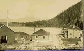
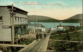
Hand coloured photo of Main Street in Prince Rupert, with various tents and buildings on either side of the wooden road. Printed annotation on recto reads: "Main Street, Prince Rupert, B.C. : On comparatively Level Line London to Yokohama." Artist's mark on lower right corner reads: "104,035 J.V."
Photograph depicts a group of men standing near a building with the sign, "James Reid Ltd. General Merchants". There are a few fences and buildings in the background.
Photograph depicts a view of main street Grand Forks BC.
Photograph depicts a view of main street Grand Forks, BC. There are power poles in the center of the photograph, buildings line the street
Photograph depicts a view of main street Grand Forks, BC.
Photograph depicts a billboard size sign on the side of a building in Grand Forks BC.
Photograph depicts a view of main street Grand Forks, BC.
Item is a map annotated in colour by the City of Prince George Planning Department depicting major residential development proposals from June 1975 to August 1977 in the City of Prince George. This map was drawn for the City of Prince George interim Community Plan.
Photograph depicts the Mamquam River near Squamish.
Image depicts a man, with what is possibly the Robson Glacier visible in the background.
Image depicts a man, possibly Kent Sedgwick, standing next to a monument which states: "In honour of the pioneers of the Ootsa Lake Valley, first settled in 1905." Located somewhere in either the Francois Lake Provincial Park or the Wistaria Provincial Park.
Photograph depicts a man bathing himself while standing in a small metal tub. Photograph description in album notes this as "His 'Semi Annual'" [bath]. On the left is a log structure, presumably a cache building. A large clearing surrounds the building and bathing man. There is a forest and bluff in the background. Possibly located near Giscome Portage.
Typed annotation on recto: "Stuart Lake B.C." Man standing in water close to cliff which is reflected in water on right. Hills on opposite shore can be seen in background.
Typed annotation on recto: "Stuart Lake Scene - British Columbia." Man stands in water close to cliff which is reflected in water on right. Hills on opposite shore can be seen in background.
Typed annotation on recto: "Tachi River, Stuart Lake, B.C." Man in tall hat, smoking from a pipe, and standing on shore with fishing rod extended over water. Tree-covered banks in background.
Photograph depicts canoe floating in water, rocky shore in foreground, opposite shore visible on horizon.
Image depicts an unknown individual reading inside a tent somewhere in Mt. Robson Provincial Park.
Unidentified man can be seen walking on railroad tracks on far right. Utility poles, field, small building and background hills are visible in image.
Image depicts a man leaning on a rock somewhere on Murray Ridge.
Image depicts an unidentified man standing on a wood bridge somewhere in South Tweedsmuir Provincial Park.
Photograph depicts a man using crutches, this person wears glasses. There is a forest in the background.
Image depicts an unknown individual climbing the side of a large boulder.
Photograph depicts one man seated in rear of canoe on still water. Trees on opposite shore in background. This man is believed to be a member of the Bourchier forestry crew.
Handwritten caption above this photo reads: "Sumit Lake." Photograph depicts man sitting facing lake among branches of trees in foreground, forest on opposite shore reflected in water.
Handwritten caption beside this photo reads: "Earth Cut". Photograph depicts a man in distance at top of steep slope of man-made embankment, trees in background. Tracks made my machinery are visible in dirt of the cut.
Photograph depicts a man standing near a very large driftwood root.
Image depicts an individual, possibly Kent Sedgwick, standing on a trail through a forest somewhere in or around Seton Portage, B.C.
Image depicts an unidentified man lighting a fire somewhere in South Tweedsmuir Provincial Park.
Photograph depicts a man with a helicopter at the location of the proposed powerhouse on Klemtu Lake.
Photograph depicts a man kneeling by row of trout between two small logs on grassy bank of a water's shore. What appears to be the vertical handle of a knife is foregrounded at bottom of image. Handwritten caption below this photo reads: "Trout Fishing."
Image depicts Manson Creek, B.C.
Image depicts a man and his family filling up their truck with gas at Manson Creek, B.C.
Image depicts the gas station at Manson Creek, B.C.
Image depicts a creek with a half collapsed shack in the background somewhere in Manson Creek. The slide is labelled "Manson workings."
Image depicts the Omineca Museum in Manson Creek, B.C.
Image depicts the road to Manson Creek, B.C.
Photograph depicts colour map displayed in unknown area, second poster semi-visible on left. See item 2008.3.1.22.34 for image believed to depict lava bed.
Map depicts the rivers, railways, and select lakes and towns located at Jasper Park between the northern boundary of the park and the townsite of Jasper. Part of the border between Alberta and British Columbia is visible on the west of the map.
Buildings in foreground, waterscape in midground, trees and snowcapped mountains in background. Printed annotation on recto reads: “Marine and Fisheries Digby Island Prince Rupert B.C. McRae Bros”
Handwritten annotations read: "At rest, after a rough passage of two days and a night from Massett, Queen Charlotte's Islands by canoe - W.H. Collison and Mrs. Collison with Indians from Masset"; "Archdeacon Collison Indian Canoe & Crew. Return from Queen Charlotte's Islands, Haida & Tsimshian Crew [...?]" Archdeacon and Mrs. Collison sit in centre of canoe.
Photograph depicts Archdeacon William Henry Collison to left of wife Marion, who stands bent over garden on right. Church steeple visible behind wood fence in background. Hills can be seen in distance.
Handwritten annotation on verso reads: "Grandad & Grannie in garden at Kincolith".
Canoe with mast floats close to shore in foreground, mountains visible across river in background.
Handwritten annotation on verso reads: "Arch. W.H. Collison & wife with native friends en route up Skeena River."
Photograph depicts Marion and William Henry Collison standing on left with shovel, Bertha Collison on right, and young Muriel and Katherine Collison in centre with shovel (eldest daughters of W.E. Collison). Wood buildings cross midground, trees and hills visible in background.
Handwritten annotation on verso reads: "Garden at Kincolith / Grandad, Grannie / Mimi, Katie / Mother".
Group of five unidentified men stand on shore to right of large dugout canoe, handling their rifles. Forest and snow-capped mountains stand on opposite shore in background.
Handwritten annotation on verso reads: "Mrs Collison (wife of Arch. Collison in Canoe en route to Hazelton B.C."
Image depicts a row of houses in the village of Masset on Haida Gwaii.
Image depicts McBride, B.C.
Image depicts the All Saints Anglican Church in McBride, B.C. The slide labels it as having "moved to PG."