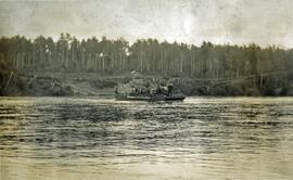
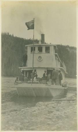
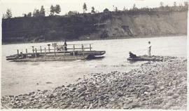
Photograph depicts a wooden ferry being steered by one man with two men waiting on a rocky shoreline. Annotation on verso of photograph states: "Ferry across Kishpiax at Hazelton"
Photograph depicts a scow loaded with three or more pack horses with men attending. The scow is crossing the river, guided by a cable. There is one building, and forest in the background.
Photograph depicts a man standing near a rough log shed. A fence line leads toward a lake. A small settlement and treed hills in the background.
Photograph depicts a ferry barge and tug operated by the Department of Highways.
Photograph depicts a ferry barge and tug that was docked on the maindland side of Barnston Island.
Image depicts a ferry entering Horseshoe Bay in the Howe Sound region.
Photograph depicts a man standing near a fenced garden plot is nearby. A body of water, a small settlement and treed hills in the background.
Photograph of lab equipment at plantsite. It is believed the equipment depicted was involved in fibre testing.
Photograph depicts a field being cleared near Miracle Beach, 20 minutes south of Campbell River, on Vancouver Island.
Image depicts the Fraser River, likely near the Hansard railroad bridge.
Typed caption glued to album page directly below photograph reads: "81. Field of Oats and Potatoes near Fort Fraser." Photographer: Dominion Stock & Bond Corporation.
Photograph depicts a landscape shot of a grassy field overlooking a forested shoreline with mountains in the background.
Photograph depicts a field roller made out of logs.
Caption describing photograph: "Field south of windbreak fallowed in readiness for Autumn seeding, most of visible area had been in clover prior to breaking."
Item is a photograph of a copy print, resulting in a low quality photographic reproduction. Reproduced as a print, slide, and a negative. Location of original photograph is unknown.
Photograph depicts fields recently cleared from virgin bush on Miracle Breach on Vancouver Island.
Photograph depicts rolling fields with a newly ploughed area in the center of the image with forest in the background.
Part of a set of 41 original black & white photographs [1908-1933-?]) of the Grand Trunk Pacific Railway line in BC depicting surveying crews, town sites (Prince Rupert and its port, Hazelton and Fort George), and First Nations Peoples.
Photograph depicts a ranch style gate looking beyond to a road and buildings.
Image depicts the intersection of 5th Ave and Highway 97 looking northeast. Map coordinates 53°55'14.0"N 122°46'54.8"W
Street view photograph of 5th Street. Printed annotation on recto reads: "5th St. Stewart, B.C. Hughes #127."
Slide depicts young figure skaters in what is believed to be the Cassiar Arena.
Two carved poles stand in foreground, a third smaller pole visible by wood structure in background.
Handwritten annotation on verso reads: "For heading of Page 12. Fin Back Whale Crest. [?] Totems, S.E. Alaska".
Image depicts numerous skiers standing near a finish line somewhere on Tabor Mountain in Prince George, B.C.
Caption: Finlay Falls 4 mls. below Thutade. Item is a landscape photograph of Finlay Falls.
Photograph depicts a wide waterfall (Finlay Falls) located above Thutade Lake with a forest in the background.
Photograph depicts a wide waterfall (Finlay Falls) seen through a tree covered landscape.
Item is a photograph of Finlay Forks trader Roy McGregor, pilot Ian Watt and British resource development designer Percy Gray in March 1957 after the first leg of Grey’s flight over the Rocky Mountain Trench.
Item is a photograph of Percy Gray and pilot Ian Watt gassing up their plane at Finlay Forks before continuing their survey of the Rocky Mountain Trench in March 1957.
Photograph depicts river and shore in foreground, hills on opposite shore in background. Handwritten annotation on recto of photograph: "Finlay Forks."
Photograph depicts a man standing in a small canoe, facing a second man walking along the shore. Hills on opposite shore in background. Handwritten annotation on recto of photograph: "Finlay Rapids. Peace River."
White caps of the Finlay Rapids.
Caption: "Finlay River from the head of Deserter Canyon"
Handwritten caption below this photo reads: "Finlay River Rapids. - 1930."
A small peninsula extends into river in left midground, rapids in foreground, trees and hills on opposite shore in background.
Image depicts numerous tractors at Finning Tractor and Equipment Co. Ltd. located along Highway 97 in Prince George, B.C.
Photograph depicts a fire float at False Creek. It is one of the two operated by the Vancouver Fire Department in Vancouver.
Photograph depicts a fire hall for fire float VFD "J.H. Carlisle" at False Creek. It is on the north shore and in line with Willow St., Vancouver.
Photograph depicts the fire hall at Lillooet, including an old hand drawn hose reel carrier.
Photograph depicts a former fire hall that was now preserved.
Photograph depicts the fire hall in Moyie, 20 miles south of Cranbrook. When the photo was taken there were 2 hose reel carts inside, a hose, and huge log stove under the hose drying tower (partially seen through window). Moyie was a prosperous village about 1900-1910.
Photograph depicts a west end fire hall in Vancouver on Nelson and Nicola St.
Image depicts the old Fire Hall, now a museum, in Stewart, B.C.
Photograph depictsa fire hydrant that was still in active use in the town of Fernie. Made by Pratt and Cady.
Photograph depicts one of the three remaining fire hydrants on location of the former Chinatown in Nanaimo, BCIt was provided and installed by the Chinese and not the city of Nanaimo. The hydrant had no identification marks.
Photograph depicts a fire hydrant that had lettering that read "McAvity and Sons Western Ltd."
Photograph depicts a fire in the second floor bedroom of a house on Nelson Street.