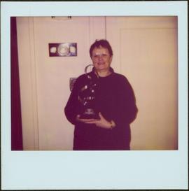
Photograph depicts Judy Kennedy holding Prince George Arts Gallery of Honour Trophy. Judy accepted the award on behalf of Bridget Moran. Hallway wall and door in background.
Caption describing photograph: "Junction of East Loop and Main Access Road N of Camp Creek. F.E.S. Aleza Lake. Typical uneven aged structure of overmature Spruce Balsam stands on high sites. Rubus site. Lacustrine silty clay."
Photograph depicts the junction of Robson and Cordero St. in west end Vancouver, B.C. The photo is looking northwest on the newly demolished block, except for some houses at far end. View is looking down Robson St., with Cordero St. intersecting the photo.
Caption describing photograph: "Low quality Hemlock isolated in understory. Junction West Branch and Main Access Road, F.E.S. Aleza Lake. 8" D.B.H. 120 years., 20-25' high." Harry Coates stands in the photograph for scale.
Photograph depicts a junction with the Coquihalla main line that had been so until 1959.
Image depicts a junk pile of bottles, cans and bags, as well as the gutted frame of an old car, at Island Cache.
Photograph taken at the station in Jura. Depicts a waiting shack that used to be around the bend on the left side of mile 60.1. Until the 1970s, there were three tracks at the location. Track on the left side was the running line. Middle trackage was passing siding, while track on the right (lifted at the time the photograph was taken) was a spur/siding that held 33 cars. The helper locomotives were from Princeton, but were being disengaged in Jura.
Photograph taken at the station in Jura. Looking towards the beginning of a passing loop in Jura.
Justa Monk and Bridget Moran stand in foreground. Unidentified individuals can be seen in bookstore in background. Bridget Moran published a book in 1994 entitled 'Justa: A First Nations Leader, Dakelhne Butsowhudilhzulh'un'.
Photograph depicts three unidentified individuals gathered around Justa Monk as he signs a copy of 'Justa: a First Nations Leader'. Plants and bookshelves in background.
Photograph depicts Justa Monk standing to right of Premier Harcourt in unknown room. John Alexis can be seen between them in background. Handwritten annotation on recto of photograph: "Justa Monk / John Alexis Tachie Village / The Premier / Taken in Prince George, B.C. Jan 23/95 / 'The day Kemano 2 was killed'."
Photograph depicts Justa Monk standing to right of Premier Harcourt in unknown room. John Alexis can be seen between them in background.
Photograph depicts Kach Indian church.
Two carved poles stand in front of a wide wooden building. Forest in background.
Printed below image: "OLD KAGAAN TOTEMS, KETCHIKAN, ALASKA".
Lofty view of Kaien Island, with other islands in the background. Printed annotation on recto reads: "Kaien Island, Prince Rupert, B.C., showing Water Front of four miles on Prince Rupert Harbor."
Photograph taken at the Kalamalka flag stop and siding that took up to 40 cars. A section house used to exist there, Davies notes. Virtually there was no public access in former days, so the siding was most likely used as a storage place for Kelowna fruit. A private speeder is found in the shadows on the main line.
Photograph taken on the shores of Kalamalka Lake.
Photograph depicts siding at the Kalamalka flag stop.
Photograph depicts Kamloops Auxiliary car #3. CN #54960 visible on the repair track after its roof renovation was completed.
Image depicts the old Kamloops Residential School which operated until either 1977 or 1978 before becoming part of the Secwepemc Musem in 1982.
Photograph depicts the Kaslo city hall built in 1898.
Photograph depicts the Kaslo City Hall, built in 1898. The first floor contained a library while the second floor held a coutroom with original furnishings in mild disarray.
Image depicts the townsite of Keithley Creek, B.C.
Image depicts the Keithley Creek, with several unknown individuals walking along the banks.
Image depicts a sign on the dirt road leading to Barkerville from Keithley Creek. The sign reads: "Barkerville 40 (via Yanks Peak) Maximum elevation 6200 FT. Summer road only. Steep grades and switchbacks not recommended for other than 4-wheel drive vehicles. You are entering an isolated mountain area; you will be on your own."
Image depicts a blue truck and a camper in the wooded area surrounding the townsite of Keithley Creek, B.C.
Photograph taken at the Kekuli Bay Provincial Park and boat launch. Image captures the view of all 25 speeders on an Okanagan tour of "Motor Car Operators West" (a U.S. group with western Canadian additions). On this segment, Davies travelled in the fifth speeder from the front.
Photograph taken at the Kekuli Bay Provincial Park and boat launch. On the speeder meet, there was always a semi-official photograph of the whole group and this was the selected spot. Here, no power boats could take the see-saw.
Image depicts a view of Kelly Lake in Downing Provincial Park.
Image depicts Kelly Lake Ranch
Image depicts a view of Kelly Lake Valley from Pavilion Mountain.
Slide depicts Kelowna and Casa Loma photographed during the day from across the Okanagan Lake in the Lakeview Heights area. Original slide index description: "Kel & Casa Loma from Lakeview Hts."
Photograph taken on the Kelowna "main" line, which was perhaps half of a mile south of the Lumby Junction on the very outskirts of Vernon.
Slide depicts the park entranceway to Kelowna on the East side of the Okanagan Lake Bridge. Original slide index description: "Park entrance to Kelowna."
Item is a photograph of a copy print that has been reproduced as a slide, resulting in low photographic quality. Location of original photograph unknown.
"Ken McCannel, a forester in the Surveys Division was in charge of the YMFTP for the entire province. He dropped in at Aleza Lake on an inspection trip at the same time as Malcolm Knapp. Professor Knapp of the forestry department of UBC went from camp to camp giving lectures on forestry to the YMFTP crews. They posed for this picture. Sills were being whip-sawn for foundations on the older buildings." -- from the notes of Ralph Schmidt in accompanying file
Photograph depicts Canadian Kendo team members Ariga, Asa, Tsumura (coach), and one other at the Kendo World Championships in England, 1974.
Photograph depicts Kendo teams lined up in winning order from left to right at the World Championships in England. Team Canada is on the far left.
Image depicts the Kenney Dam near Cheslatta, B.C.
Image depicts Kenny Dam, south of Francois Lake, and southwest of Vanderhoof, B.C.
Image depicts a stretch of land; the photo was taken from the top of Kenny Dam, south of Francois Lake.
Image depicts a boat on the Nechako Reservoir at Kenny Dam.
Image depicts a boat dock on the Nechako Reservoir at Kenny Dam.
Image depicts Kent Sedgwick sitting on the bank of a river. An old beehive burner is visible in the background. Located somewhere in or near Penny, B.C.
Image depicts Kent Sedgwick speaking to a group of hikers.
Image depicts a man looking at some papers. It is most likely Kent Sedgwick.
Image depicts Kent Sedgwick walking along the coastline of Haida Gwaii, B.C.
Image depicts Kent Sedgwick with a dog at his feet, somewhere in Mt. Robson Provincial Park.
Image depicts Kent Sedgwick crouching and holding a stick; the slug on the end is barely visible. Located somewhere on Haida Gwaii.