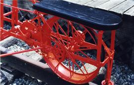
Photograph depicts a velocipede outside the museum depot in Fort Langley.
Handwritten annotation on recto of photograph: "ASBESTOS FIBRE VEINS AS THEY OCCURR IN A ROCK FACE". Photo caption under printed copy of image in 1952 Annual Report: "North Wall of adit approximately 225 feet from portal showing asbestos veinlets."
Image depicts an example of varves, an annual layer of sediment or rock, with a pipe used for reference size. It is possibly located at the airport in Prince George, B.C.
Image depicts an example of varves, an annual layer of sediment or rock, possibly located at the airport in Prince George, B.C.
Image depicts a Catholic Church on Stoney Creek Road in Vanderhoof, B.C.
Image depicts a barn with large, Harvestore Systems. It is possibly located on one of the many farms near Vanderhoof, B.C.
Postcard depicts Vancouver's "Old 374" crossing the Spuzzum River, Fraser Canyon, BC
Photograph depicts the Vancouver Shipyards Ltd. on 555 Denman St. in Vancouver, B.C., looking south from Coal Harbour waters.
Photograph depicts the Vancouver Poets Shakespeare Company rehearsing for a Midsummer Night's Dream. Right to left: Ralph Maud, Bob Micholson, unknown, Peter Menu.
Photograph depicts a Vancouver Iron Works built steam donkey in use until the early 1950s. It was purchased for $800 by an enthusiast in 1963 , set up beside home and roadside at Sayward near Kelsey Bay on North Vancouver Island.
Photograph depicts Vancouver Fireboat #2 at the pier in front of the immigration building.
Photograph depicts Vancouver Fireboat #2 having its hull sandblasted in a dry dock at the Burrard Shipyard & Marine Ways Ltd. at 1729 West Georgia St., Vancouver.
Photograph depicts a fire truck being used to deal with a bedroom fire in Vancouver.
Photograph depicts the Vancouver Fire Department fire boat #2 moored at the federal dock beside the immigration building in Vancouver.
Photograph depicts Vancouver City College, formerly King Edward Secondary School.
Photograph depicts a pier. Handwritten annotation below the photograph reads, "as above. taken from Howe street"
Photograph depicts a pier. Handwritten annotation below the photograph reads, "Vancouver, C.P.R. Pier taken from Pier A"
Photograph depicts depicts a brush covered valley with tree-covered mountains on either side.
Photograph depicts valley of Kitseucla creek looking north from 55th parallel.
Photograph depicts horse packs piled in center of photograph, several men stand the to left, several horses on the right, large peaked mountain in the background.
Photograph depicts lush undergrowth with trees and a mountain peak in the distance, valley of Kitseucla creek looking north from 55th parallel.
Photograph depicts four men in center of photograph, several canvas tents erected nearby, high mountain peak in the background.
Photograph depicts lush meadow with trees and a mountain peak in the distance.
Photograph depicts the Kettle river valley between Cascade BC and the American Boundary.
Photograph depicts a view from a high ridge looking over a valley.
Photograph depicts a tree-filled valley leading up to a snow-covered mountain range.
Image depicts a valley of fossil beds, possibly the Bulkley Valley.
Image depicts a view of a small valley in Mt. Robson Provincial Park.
Image depicts a river running through a valley-like area somewhere near Bralorne, B.C.
Image depicts the Valemount CN Station.
Image depicts a distant view of what appears to be a body of water, with numerous mountains in the background. The slide is labelled "Valemount reservoir."
Image depicts a view of a mountain range near Valemount, B.C. Valemount is barely visible among the trees on the right side of the image.
Image depicts a view of Valemount with numerous mountains in the background.
Image depicts a view of Valemount, with numerous mountains in the background.
The item is a photograph of a utility trailer and parking lot on 3rd Avenue in Prince George. Trailer is from GE Capital Modular Space with a sign stating "Third Ave. Revitalization : Surface Demolition and Removal of Canopies"
Photograph depicts a row of utility poles between Bella Coola and Anahim Lake during the WWII Polar Bear training exercise.
Photograph depicts large ship in open water, Handwritten annotation below photograph reads, "U. S. S. Pennsylvania, Vancouver. 28/6/28
Photograph depicts the U.S.S. Cowell, a heavy destroyer in English Bay, Vancouver during the maritime festival, with a yacht from the Victoria Yacht Club alongside.
Photograph depicts the U.S.S. Cowell, a heavy destroyer in English Bay, Vancouver during the maritime festival.
Item is an original bound copy of "Use and Management of Land on Valley Train Deposits", Gary Runka's 1968 thesis presented to the Faculty of the Graduate School of Cornell University for the Degree of Master of Science.
Photograph taken at the Penticton Airport where WWII military airplanes meet. This US military plane was flown by a US Air Militia on a courtesy visit. It was built in the early 1950's.
Image depicts a damaged, upturned car in Island Cache.
Image depicts an individual standing next to what appears to be the base of a very large, uprooted tree, located somewhere in the coastal forest of Haida Gwaii, B.C.
Postcard depicts one of the upper sprial tunnels in Field, BC