Print preview Close

Showing 3165 results

Archival description
3023 results with digital objects Show results with digital objects
Kinuseo Falls
2000.19.2.117 · Item · 29 Aug. 1927-26 Sept. 1927
Part of Prentiss Gray Collection

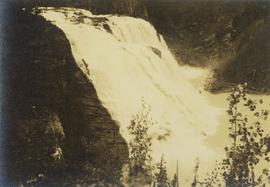
Photograph depicts a close perspective of a waterfall falling down a rocky cliff side. In the background a burnt forest environment is visible. The waterfall is know as both Kinuseo Falls and Kinoosao Falls.

2000.1.1.3.15.25 · Item · 1961
Part of Cassiar Asbestos Corporation Ltd. fonds

Photograph depicts ore haul truck at dump in mine, driver visible, mountain range in background. Handwritten annotation on recto of photograph: "Kenworth - Model 802 dumping stripping waste at 6565 Elevation", on verso: "1961".

Kent Sedgwick and Glacier
2012.13.1.56.56 · Item · 1973
Part of J. Kent Sedgwick fonds

Image depicts Kent Sedgwick pointing out what is possibly the Robson Glacier in the background. Another, unknown individual is also present in the image.

Kent Sedgwick and a Slug
2012.13.1.78.53 · Item · 1982
Part of J. Kent Sedgwick fonds

Image depicts Kent Sedgwick crouching and holding a stick; the slug on the end is barely visible. Located somewhere on Haida Gwaii.

Kent Sedgwick
2012.13.1.88.35 · Item · 1980
Part of J. Kent Sedgwick fonds

Image depicts Kent Sedgwick sitting on the bank of a river. An old beehive burner is visible in the background. Located somewhere in or near Penny, B.C.

Kenny Dam
2012.13.1.51.164 · Item · [1999?]
Part of J. Kent Sedgwick fonds

Image depicts Kenny Dam, south of Francois Lake, and southwest of Vanderhoof, B.C.

Kenny Dam
2012.13.1.51.163 · Item · [1999?]
Part of J. Kent Sedgwick fonds

Image depicts a stretch of land; the photo was taken from the top of Kenny Dam, south of Francois Lake.

Kelowna and Casa Loma
2020.4.8.1.0002 · Item · May 1968
Part of G. Gary Runka fonds

Slide depicts Kelowna and Casa Loma photographed during the day from across the Okanagan Lake in the Lakeview Heights area. Original slide index description: "Kel & Casa Loma from Lakeview Hts."

2012.13.1.69.21 · Item · [1981?]
Part of J. Kent Sedgwick fonds

Image depicts a sign on the dirt road leading to Barkerville from Keithley Creek. The sign reads: "Barkerville 40 (via Yanks Peak) Maximum elevation 6200 FT. Summer road only. Steep grades and switchbacks not recommended for other than 4-wheel drive vehicles. You are entering an isolated mountain area; you will be on your own."

Keithley Creek
2012.13.1.69.20 · Item · [1981?]
Part of J. Kent Sedgwick fonds

Image depicts the Keithley Creek, with several unknown individuals walking along the banks.

Junk Pile
2012.13.1.22.06 · Item · 1970
Part of J. Kent Sedgwick fonds

Image depicts a junk pile of bottles, cans and bags, as well as the gutted frame of an old car, at Island Cache.

Jean's Apple Tree
2009.5.3.123 · Item · [ca. 1920]
Part of Taylor-Baxter Family Photograph Collection

Photograph features one apple tree, field in background. Handwritten annotation on recto of photograph: "This shows size of trees." It is believed that this photograph was given to Lillian & A.K. Bourchier by their niece Jean.