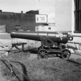
Photograph depicts an iron cannon found outside the BC Regiment Armoury in Vancouver.
Image depicts Iron Road North, and a creek surrounded by trees. Located north of Woodpecker, B.C.
Image depicts Iron Road South, which is located north of Woodpecker, B.C.
Image depicts the street sign for Iron Road South, which is located north of Woodpecker, B.C.
Image depicts what is possibly an irrigation channel somewhere in Seton Portage, B.C.
Image depicts an irrigation ditch in Lillooet, B.C.
Image depicts a pile of irrigation pipes on a dairy farm somewhere near Quesnel, B.C.
Image depicts the Isaac Falls.
Image depicts a log jamb at the Isaac Falls.
Image depicts Isaac Lake.
Image depicts Isaac Lake from the Betty Wendle campsite.
Image depicts a camp at the Betty Wendle campsite at Isaac Lake.
Image depicts the sunset over Isaac Lake from the Betty Wendle campsite.
Iska sits on horse led by Ward, autumn trees in background.
Photograph depicts a tall, rocky island rising out of the Peace River above Hudson's Hope.
Small rocky island very near to shore depicted at low tide; sandy beach visible in mid ground along with a temporarily beached sailboat. Handwritten annotation in pencil on verso reads: “Ninstints site of the fort opposite village”.
Image depicts an old, boarded up school in Island Cache, B.C.
Photograph depicts the "Island Chief" tug of the Island Tug and Barge Company, off pier A3 (CPR) in Vancouver.
Image depicts a grocery store at Island Cache.
Photograph depicts a forested island in Bear Hole Lake as seen from the shore. In the foreground of the image is a barren tree line.
Photograph depicts a forested island in Bear Hole Lake as seen from the shore. In the foreground is a barren tree line.
Photograph depicts an island tug in Vancouver harbour.
Photograph depicts "Island Tug #125," on the north arm of the Fraser River. Travelling downstrean from Patulla Bridge, New Westminster, and the CNR Lulu Island rail bridge.
Photograph depicts islands along the Peace River seen from above, located near Hudson's Hope. In the background of the image tree-covered hills are visible.
Item is a photograph of Mr. Williston’s mother at the age of 86 years.
Item is a photograph of Islay McCalman Williston, Mr. Williston’s mother.
Image depicts the ferry at Isle Pierre, B.C.
Image depicts the ferry in Isle Pierre, B.C.
Image depicts the dock for ferries in Isle Pierre, B.C.
Image depicts an old, boarded up store in Isle Pierre, B.C.
Caption describing photograph: "Isolated Hemlock. West Branch Road, F.E.S. Aleza."
Caption describing photograph: "As GBW Film 4 Frame 1 (2007.1.30.2.040). 13" DBH Height 45', +/- 120 years old." Harry Coates stands in the photograph for scale.
Photograph depicts Ivan Rideout holding a Molten basketball. Rideout was the national free-throw champion in the 1978 baskethon.
Photograph depicts a man dressed in a suit, tie and overcoat with a house in the background, possibly in Prince Rupert or another location on the British Columbia coast. Handwritten annotation below photograph reads, "J. Buntom Knight".
Image depicts an unknown individual in the J. Edwards Camp in South Tweedsmuir Provincial Park.
Photograph depicts 77 year old J. Harry Crawshaw breaking through concrete blocks with karate chop.
Photograph depicts 77 year old J. Harry Crawshaw with raised arm behind intact cement blocks prior to karate chop.
Photograph depicts Jack Baker holding cross-country skis in the snow with a dog.
Photograph depicts Jack Baker's cabin with shoreline and plane as seen from a boat on Tutizzi Lake.
Photograph depicts Jack Baker of Fort St John standing in the doorway of his log cabin on Tutizzi Lake.
Photograph depicts Jack Baker's log cabin on Tutizzi Lake covered with snow.
Photograph depicts an adolescent boy standing on the edge of the water with a stick. Handwritten annotation below photograph reads, "Jack Child".
Item is a photograph of a copy print, resulting in a low quality photographic reproduction. Reproduced as a print, slide, and a negative. Location of original photograph is unknown.
Photograph depicts Jack Lee and the survey crew's 1930 Buick Series 40 car below the Boston Bar tunnel on their return trip.
Photograph depicts Jack Lee (front) and Gordon Wyness drinking lakeside in Marble Canyon. The survey crew had been travelling along Marble Canyon Road, which is now Highway 99. The lakes in Marble Canyon are now named Turquoise Lake, Crown Lake, and Pavilion Lake. Wyness notes the blueness of these lakes and the white mountains of this area.
Photograph depicts (from left) Jack Lee and Gordon Wyness sitting on a car next to their equipment while surveying at an Indian Reserve. A cabin on the reserve is also depicted. According to the transcription on the photograph verso, they were surveying road through an "Indian Reserve South of South bank François Lake".
Photograph depicts (from left) Jack Lee and Philip Monckton leaning up against their 1930 Buick Series 40 car before leaving for Southbank Francois Lake. Behind them is the cabin they stayed in at Burns Lake, which was owned by Ben[?] Smith.
Photograph depicts Jack Lee with gear in front of a tent at Bobtail [Lake?] campsite after returning from Bobtail Mountain where the crew had camped overnight without a tent.