2023.2.2.9.6
·
File
·
2001
Part of Dr. Paul Sanborn fonds
16 results with digital objects
Show results with digital objects
2023.2.2.9.5
·
File
·
2001
Part of Dr. Paul Sanborn fonds
2023.2.2.8.20
·
File
·
2009
Part of Dr. Paul Sanborn fonds
2023.2.2.8.19
·
File
·
2004
Part of Dr. Paul Sanborn fonds
This file contains the following photographs in both print photograph and negative format:
Y04-31 (EW)
Date: July 23, 2004
Location Coordinates: 61º 3’ 9.2” N, 138º 21’ 30.3’ W, 837.2 m asl (± 6.4 m)
Site Description: crest of N-S esker ridge
Sample Depths & Descriptions: Y04-31-01: 0-10 cm
Print roll 13, #1-3
Corresponding slides: Slide roll 7, #12-11
Y04-32
Date: July 23, 2004
Location Coordinates: 61º 3’ 7.4” N, 138º 21’ 27.7’ W, 823.7 m asl (± 13.7 m)
Site Description: toeslope on NE side of same ridge as for Y04-31; 20° slope, NE aspect; Cryosol with permafrost at 34 cm; 30 cm of forest floor organic horizons; abundant charred wood fragments at top of mineral soil & in lowest part of organic horizon.
Print roll 13, #4-5
Corresponding slides: Slide roll 7, #10-9
Y04-34
Date: July 23, 2004
Location Coordinates: 61º 3’ 47.7” N, 138º 21’ 2.5’ W, 838 m asl
Site Description: Toe of 30º, W-facing grassland slope. Colluviated loess with White River tephra at 8-9 cm, brownish paleosol (9-35 cm), overlying sandy glaciofluvial at 35-70 cm+.
Sample Depths & Descriptions: Y04-34-01: charcoal at 34 cm
Print roll 13, #6-7
Corresponding slides: Slide roll 7, #8-7
Y04-35 (EW)
Date: July 23, 2004
Location Coordinates: 61º 3’ 49.9” N, 138º 21’ 1.1” W, 854.4 m asl (± 6.3 m)
Sample Depths & Descriptions: Y04-35-01: 0 – 10 cm
Print roll 13, #8-10 (Location not recorded: Print roll 13, #11-12)
Corresponding slides: Slide roll 7, #6-5
Y04-36
Date: July 23, 2004
Location Coordinates: 61º 8’ 11.5” N, 138º 25’ 50.8” W, 825.6 m asl (± 14.5 m)
Site Description:
- 10-0 cm - LF
- 0-15 cm - Bmk1 (7.5YR 4/6 m)
- 15-28 cm - Bmk2 (2.5Y 4/3 m)
- 28-48 cm - Ck
- 48-55 cm+ - IICk (sandy gravelly glaciofluvial)
- No charcoal visible in mineral horizons
Print roll 13, #13-14
Corresponding slides: Slide roll 7, #4-3
Y04-37
Date: July 23, 2004
Location Coordinates: (roadcut adjacent to Y04-36)
Site Description: multiple colour bands in Slims soil; some charcoal blobs (not sampled) which are right size to have been roots.
Print roll 13, #15-19
Corresponding slides: Slide roll 7, # 2-1
2023.2.2.8.18
·
File
·
2004
Part of Dr. Paul Sanborn fonds
This file contains the following photographs in both print photograph and negative format:
Cultus Bay Rd.
(landscape views looking W from road; lake is likely at ~61°4’ 10.5”N, 138°22’ 31.5”)
Print roll 12, #0A-2A
Corresponding slides: Slide roll 7, #23-22
Keyhole Pond (landscape views)
Print roll 12, #3A-4A
Y04-23 (Saddle W of Keyhole Pond)
Date: July 22, 2004
Location Coordinates: 61º 4’ 46.5” N, 138º 22’ 32.2’ W, 828 m asl (± 8.0 m)
Site Description: 7º, NW-facing slope. Cumulic profile in colluviated loess with White River tephra at 10 cm, brownish paleosol at 23-27 cm, glaciofluvial sand at 50 cm.
Sample Depths & Descriptions: Y04-23-01 – charcoal at 23-27 cm, immediately above paleosol
Print roll 12, #5A-6A
(Location not recorded: Print roll 12, #7A-8A)
Y04-24 (W side of Rat Lake)
Date: July 22, 2004
Location Coordinates: 61º 9’ 54.6” N, 138º 25’ 41.6” W, 807.7 m asl (± 13.5 m)
Site Description: 23° slope, NE aspect; cumulic profile with White R ash at 20 cm; no obvious charcoal bands.
Print roll 12, #9A-10A (9A print is missing)
"Ian's Lake"(W of NW corner of Rat Lake)
Location Coordinates: 61º 10’ 1.4” N, 138º 25’ 47.7” W, 773.4 m asl (± 9.8 m) (coordinates are for ridge crest on NE side of lake)
Site Description: basal date 700 BP in terrestrial sediments; NE side has grassy 30°slope
Print roll 12, #11A
Y04-25 (S shore of “Ian’s Lake”, NW of Rat Lake)
Date: July 22, 2004
Location Coordinates: 61º 10’ 0.7” N, 138º 25’ 49.2” W, 781.8 m asl (± 8.8 m)
Site Description: 35 cm of colluviated loess over gravelly sandy glaciofluvial; no visible charcoal bands; buried soil at 25-35 cm; White R ash at 6-8 cm.
Print roll 12, #12A-13A
Y04-26 (EW)
Date: July 23, 2004
Location Coordinates: 61º 1’ 59.8” N, 138º 21’ 53.6” W, 836.1 m asl (± 7.7 m)
Site Description: grassland at crest of 33° terrace scarp, S aspect.
Sample Depths & Descriptions: Y04-26-01 – 0-10 cm
Print roll 12, #14A-15A
Corresponding slides: Slide roll 7, #21-20
Y04-27
Date: July 23, 2004
Location Coordinates: 61º 2’ 0.9” N, 138º 21’ 53.6” W, 843.6 m asl (± 5.8 m) (~ 35 m N of Y04-26)
Site Description: spruce forest on terrace surface; level.
- 0-8 cm - Loess-rich forest floor; strongly calcareous.
- 8-13 cm - Bmk
- 13-15 cm - Discontinuous pockets of White R ash
- 15-35 cm - Bmk (Slims soil) – no charcoal visible
- 35-75 cm - Gray calcareous loess.
- 75 cm+ - Gravelly sandy glaciofluvial deposit.
Print roll 12, #16A-17A
Corresponding slides: Slide roll 7, #19-18
Y04-28 (EW)
Date: July 23, 2004
Location Coordinates: 61º 2’ 34.4” N, 138º 21’ 57.0” W, 820.2 m asl (± 6.1 m)
Site Description: grassland on esker crest W of Jenny L; 30° slope, SW aspect
Sample Depths & Descriptions: Y04-28-01: 0-10 cm
Print roll 12, #18A-19A
Corresponding slides: Slide roll 7, #17-16
Y04-30 (between eskers, W of Jenny Lake)
Date: July 23, 2004
Location Coordinates: 61º 2’ 31.6” N, 138º 21’ 52.3’ W, 817.6 m asl (± 6.1 m)
Site Description: Level (base of saddle). Colluviated loess to 90 cm+, with White River tephra at 15-17 cm, brownish paleosol at 17-35 cm, underlain by turbated Bmku with multiple charcoal-rich bands.
Sample Depths & Descriptions:
- Y04-30-01 – charcoal at 13 cm (above WR tephra)
- Y04-30-02 – charcoal at 22 cm (below WR tephra)
- Y04-30-03 – charcoal at 75 cm
Print roll 12, #20A-22A
Corresponding slides: Slide roll 7, #15-13
Jenny Lake (landscape views)
Print roll 12, #23A-24A
2023.2.2.8.17
·
File
·
2004
Part of Dr. Paul Sanborn fonds
This file contains the following photographs in both print photograph and negative format:
Thorsen Bay
Print roll 11, #01-2A
Corresponding slides: slide roll 6, #12-10
Y04-19 (27.5 km on Cultus Bay Rd., near Thorsen Bay)
Date: July 22, 2004
Location Coordinates: 61º 12’ 3.0” N, 138º 28’ 58.3’ W, 819 m asl (± 18.9 m)
Site Description: Roadcut at base of 30º, E-facing slope. Colluviated loess overlies sandy glaciofluvial at 120 cm. Prominent paleosol with “cumulic” B horizon at 80-120 cm, with strong effervescence throughout exposure.
Print roll 11, #3A-5A (profile), #6A-10A (landscape)
Corresponding slides: slide roll 6, #9-7 (profile), #6-1 (landscape)
Sample Depths & Descriptions: Y04-19-01 – charcoal at 95 cm
Roadcut opposite ~ 30 m to NE on grassy S aspect (10° slope) with 15-20 cm of calcareous loess and sand over 2 cm White River ash; strongly effervescent throughout.
Print roll 11, #11A-12A (profile)
Corresponding slides: slide roll 7, #36-35 (profile)
Thorsen Bay landscape
Print roll 11, #13A-16A
Corresponding slides: Slide roll 7, #34-32
Y04-20B
Date: July 22, 2004
Location Coordinates: 61º 10’ 16.5” N, 138º 26’ 18.7’ W, 797.5 m asl (± 5.9 m)
Site Description: wind-eroded Slims soil on glaciolacustrine with contorted bedding (exposed on blown-out roadcut); calcareous to surface; White R ash pockets at 10-20 cm; S aspect, 5° slope.
Print roll 11, #17A-21A
Corresponding slides: Slide roll 7, #31-26
Y04-22
Date: July 22, 2004
Location Coordinates: 61º 9’ 39.24” N, 138º 25’ 7.8’ W, 790.6 m asl (± 6.4 m)
Site Description: toe of 30° slope, W aspect (grassy slope with poplar at toe); 1.0-1.2 of colluviated loess over gravelly glaciofluvial with buried soil at 70-80 cm
Print roll 11, #22A-24A
Corresponding slides: Slide roll 7, #25-24
2023.2.2.8.16
·
File
·
2004
Part of Dr. Paul Sanborn fonds
This file contains the following photographs in both print photograph and negative format:
Kluane Lake (S. shore, near Kluane Lake Research Station)
Print roll 10, # 34-36
2023.2.2.8.15
·
File
·
2004
Part of Dr. Paul Sanborn fonds
Slide roll contains the following photographs:
Y04-19 (27.5 km on Cultus Bay Rd., near Thorsen Bay)
Date: July 22, 2004
Location Coordinates: 61º 12’ 3.0” N, 138º 28’ 58.3’ W, 819 m asl (± 18.9 m)
Site Description: Roadcut at base of 30º, E-facing slope. Colluviated loess overlies sandy glaciofluvial at 120 cm. Prominent paleosol with “cumulic” B horizon at 80-120 cm, with strong effervescence throughout exposure.
Sample Depths & Descriptions: Y04-19-01 – charcoal at 95 cm
Roadcut opposite ~ 30 m to NE on grassy S aspect (10° slope) with 15-20 cm of calcareous loess and sand over 2 cm White River ash; strongly effervescent throughout.
Slide roll 7, #36-35 (profile)
Corresponding prints and negatives: Print roll 11, #11A-12A (profile)
Thorsen Bay landscape
Slide roll 7, #34-32
Corresponding prints and negatives: Print roll 11, #13A-16A
Y04-20B
Date: July 22, 2004
Location Coordinates: 61º 10’ 16.5” N, 138º 26’ 18.7’ W, 797.5 m asl (± 5.9 m)
Site Description: wind-eroded Slims soil on glaciolacustrine with contorted bedding (exposed on blown-out roadcut); calcareous to surface; White R ash pockets at 10-20 cm; S aspect, 5° slope.
Slide roll 7, #31-26
Corresponding prints and negatives: Print roll 11, #17A-21A
Y04-22
Date: July 22, 2004
Location Coordinates: 61º 9’ 39.24” N, 138º 25’ 7.8’ W, 790.6 m asl (± 6.4 m)
Site Description: toe of 30° slope, W aspect (grassy slope with poplar at toe); 1.0-1.2 of colluviated loess over gravelly glaciofluvial with buried soil at 70-80 cm
Slide roll 7, #25-24
Corresponding prints and negatives: Print roll 11, #22A-24A
Cultus Bay Rd.
(landscape views looking W from road; lake is likely at ~61°4’ 10.5”N, 138°22’ 31.5”)
Slide roll 7, #23-22
Corresponding prints and negatives: Print roll 12, #0A-2A
Y04-26 (EW)
Date: July 23, 2004
Location Coordinates: 61º 1’ 59.8” N, 138º 21’ 53.6” W, 836.1 m asl (± 7.7 m)
Site Description: grassland at crest of 33° terrace scarp, S aspect.
Sample Depths & Descriptions: Y04-26-01 – 0-10 cm
Slide roll 7, #21-20
Corresponding prints and negatives: Print roll 12, #14A-15A
Y04-27
Date: July 23, 2004
Location Coordinates: 61º 2’ 0.9” N, 138º 21’ 53.6” W, 843.6 m asl (± 5.8 m) (~ 35 m N of Y04-26)
Site Description: spruce forest on terrace surface; level.
- 0-8 cm - Loess-rich forest floor; strongly calcareous.
- 8-13 cm - Bmk
- 13-15 cm - Discontinuous pockets of White R ash
- 15-35 cm - Bmk (Slims soil) – no charcoal visible
- 35-75 cm - Gray calcareous loess.
- 75 cm+ - Gravelly sandy glaciofluvial deposit.
Slide roll 7, #19-18
Corresponding prints and negatives: Print roll 12, #16A-17A
Y04-28 (EW)
Date: July 23, 2004
Location Coordinates: 61º 2’ 34.4” N, 138º 21’ 57.0” W, 820.2 m asl (± 6.1 m)
Site Description: grassland on esker crest W of Jenny L; 30° slope, SW aspect
Sample Depths & Descriptions: Y04-28-01: 0-10 cm
Slide roll 7, #17-16
Corresponding prints and negatives: Print roll 12, #18A-19A
Y04-30 (between eskers, W of Jenny Lake)
Date: July 23, 2004
Location Coordinates: 61º 2’ 31.6” N, 138º 21’ 52.3’ W, 817.6 m asl (± 6.1 m)
Site Description: Level (base of saddle). Colluviated loess to 90 cm+, with White River tephra at 15-17 cm, brownish paleosol at 17-35 cm, underlain by turbated Bmku with multiple charcoal-rich bands.
Sample Depths & Descriptions:
- Y04-30-01 – charcoal at 13 cm (above WR tephra)
- Y04-30-02 – charcoal at 22 cm (below WR tephra)
- Y04-30-03 – charcoal at 75 cm
Slide roll 7, #15-13
Corresponding prints and negatives: Print roll 12, #20A-22A
Y04-31 (EW)
Date: July 23, 2004
Location Coordinates: 61º 3’ 9.2” N, 138º 21’ 30.3’ W, 837.2 m asl (± 6.4 m)
Site Description: crest of N-S esker ridge
Sample Depths & Descriptions: Y04-31-01: 0-10 cm
Slide roll 7, #12-11
Corresponding prints and negatives: Print roll 13, #1-3
Y04-32
Date: July 23, 2004
Location Coordinates: 61º 3’ 7.4” N, 138º 21’ 27.7’ W, 823.7 m asl (± 13.7 m)
Site Description: toeslope on NE side of same ridge as for Y04-31; 20° slope, NE aspect; Cryosol with permafrost at 34 cm; 30 cm of forest floor organic horizons; abundant charred wood fragments at top of mineral soil & in lowest part of organic horizon.
Slide roll 7, #10-9
Corresponding prints and negatives: Print roll 13, #4-5
Y04-34
Date: July 23, 2004
Location Coordinates: 61º 3’ 47.7” N, 138º 21’ 2.5’ W, 838 m asl
Site Description: Toe of 30º, W-facing grassland slope. Colluviated loess with White River tephra at 8-9 cm, brownish paleosol (9-35 cm), overlying sandy glaciofluvial at 35-70 cm+.
Sample Depths & Descriptions: Y04-34-01: charcoal at 34 cm
Slide roll 7, #8-7
Corresponding prints and negatives: Print roll 13, #6-7
Y04-35 (EW)
Date: July 23, 2004
Location Coordinates: 61º 3’ 49.9” N, 138º 21’ 1.1” W, 854.4 m asl (± 6.3 m)
Sample Depths & Descriptions: Y04-35-01: 0 – 10 cm
Slide roll 7, #6-5
Corresponding prints and negatives: Print roll 13, #8-10
(Location not recorded: Print roll 13, #11-12)
Y04-36
Date: July 23, 2004
Location Coordinates: 61º 8’ 11.5” N, 138º 25’ 50.8” W, 825.6 m asl (± 14.5 m)
Site Description:
- 10-0 cm - LF
- 0-15 cm - Bmk1 (7.5YR 4/6 m)
- 15-28 cm - Bmk2 (2.5Y 4/3 m)
- 28-48 cm - Ck
- 48-55 cm+ - IICk (sandy gravelly glaciofluvial)
- No charcoal visible in mineral horizons
Slide roll 7, #4-3
Corresponding prints and negatives: Print roll 13, #13-14
Y04-37
Date: July 23, 2004
Location Coordinates: (roadcut adjacent to Y04-36)
Site Description: multiple colour bands in Slims soil; some charcoal blobs (not sampled) which are right size to have been roots.
Slide roll 7, # 2-1
Corresponding prints and negatives: Print roll 13, #15-19
2023.2.2.8.14
·
File
·
2004
Part of Dr. Paul Sanborn fonds
Slide roll contains the following photographs:
Thorsen Bay
Print roll 11, #01-2A; slide roll 6, #12-10
Y04-19 (27.5 km on Cultus Bay Rd., near Thorsen Bay)
Date: July 22, 2004
Location Coordinates: 61º 12’ 3.0” N, 138º 28’ 58.3’ W, 819 m asl (± 18.9 m)
Site Description: Roadcut at base of 30º, E-facing slope. Colluviated loess overlies sandy glaciofluvial at 120 cm. Prominent paleosol with “cumulic” B horizon at 80-120 cm, with strong effervescence throughout exposure.
Slide roll 6, #9-7 (profile), #6-1 (landscape)
Corresponding prints and negatives: Print roll 11, #3A-5A (profile), #6A-10A (landscape)
2023.2.2.8.13
·
File
·
2003
Part of Dr. Paul Sanborn fonds
File consists of Kluane Lake photographs from 2003 in digital format.
2023.2.2.8.12
·
File
·
2003
Part of Dr. Paul Sanborn fonds
This file contains the following photographs in both print photograph and negative format:
Slims River delta
Date: August 11, 2003
(location not recorded)
Print roll 5, #1-3 (Corresponding slides: Slides roll 3, #15-14)
Grizzly bear
Date: August 12, 2003
(beside Cultus Bay Rd.; location not recorded)
Print roll 5, #6-7
Y03-08 (Cultus Bay Rd. – at top of switchbacks)
Date: August 12, 2003
Location Coordinates: 61° 3’ 43.1” N, 138° 21’ 4.0” W, 833.8 m asl (± 5.1 m)
Site Description: good exposure of loess (35 cm) with Slims Soil over glaciofluvial terrace – pinches out downslope [note: this site was sampled because of development of buried paleosol, and was not part of biological crust study by Marsh et al. (2006)]
Sample Depths & Descriptions:
- Y03-08-01 - 45-48 cm - Ahkb (7.5YR 3/3 d; strongly effervescent)
- Y03-08-02 - 48-56 cm - Bmkb (7.5YR 4/3 d; strongly effervescent)
- Y03-08-03 - 56-70 cm - Ccab (2.5Y 5/2 d; strongly effervescent)
- (not sampled) - 70 cm+ - IICca (glaciofluvial; strongly effervescent)
- Intact sample: 56-36 cm - depth (including Slims Soil)
Print roll 5, #8-10, 17-18 (Corresponding slides: Slides roll 3, #13-11, 5-4)
Y03-09 (cliff top on E. shore of Kluane L. at Christmas Bay)
Date: August 12, 2003
Location Coordinates: 61° 4’ 0.0” N, 138° 22’ 35.3” W, 828.3 m asl (± 7.3 m)
Site Description: ~ 60 cm loess over glaciofluvial gravels
Sample Depths & Descriptions:
- Y03-09-01 - Nostoc crust
- Y03-09-02 - Tortula ruralis – Cetraria crust
- Y03-09-03 - 0-14 cm - ACk (10YR 3\2 d)
- Y03-09-04 - 14-16 cm - Ahkb1 (10YR 2/2 d)
- Y03-09-05 - 16-18 cm - Ck1 (10YR 4/3 d)
- Y03-09-06 - 18-20 cm - Ahkb2 (10YR 3/2 d; discontinuous)
- Y03-09-07 - 20-27 cm - Bmkb1 (10YR 4/3 d)
- Y03-09-08 - 27-33 cm - Bmkb2 (7.5YR 4/3 d)
- Y03-09-09 - 33-46 cm - Bmkb3 (10YR 4/3 d)
- Y03-09-10 - 46-55 cm - Ck2 (2.5Y 5/3 d)
- (not sampled) - 55-60 cm+ - IICk (glaciofluvial gravels)
Print roll 5, #11-15 (Corresponding slides: Slide roll 3, #10-6)
Y03-10 (shore bluff N. of Silver City)
Date: August 12, 2003
Location Coordinates: 61° 2’ 55.0” N, 138° 23’ 17.2” W, 806.7 m asl (± 7.3 m)
Site Description: 70% slope, SW aspect; vegetation: Elymus, Carex, Artemisia, Erigeron
Sample Depths & Descriptions:
- Y03-10-01 - Crust
- Y03-10-02 - 0-18 cm - ACk (10YR 4/2 m; strongly effervescent)
- Y03-10-03 - 18-25 cm - Ahkb(?) (10YR 4/2 m; strongly effervescent)
- Y03-10-04 - 25-40 cm - Ck (2.5Y 5/2.5 m; strongly effervescent)
- (not sampled) - 40 cm+ - IICk (glaciofluvial gravels; strongly effervescent)
Print roll 5, #19-22 (Corresponding slides: Slide roll 3, #3-1)
Silver City ghost town (location not recorded)
Date: August 12, 2003
Print roll 5, #23-24
Y03-11 (Silver City road section)
Date: August 12, 2003
Location Coordinates: 61° 2’ 3.6” N, 138° 22’ 48.8” W, 806.7 m asl (± 8.7 m)
Site Description: roadcut through SW-facing hill exposes loess over glaciofluvial gravel, with 4 paleosols in colluviated loess
Sample Depths & Descriptions:
- Y03-11-01 - 0-18 cm - ACk (fresh loess)
- Y03-11-02 - 18-47 cm - Soil 1 – Bmk
- Y03-11-03 - 47-100 cm - Loess
- Y03-11-04 - 100-110 cm - Soil 2 – includes charcoal
- Y03-11-05 - 110-160 cm - Loess with secondary carbonate in root channel
- Y03-11-06 - 160-170 cm - Soil 3 – Ahk with charcoal
- Y03-11-07 - 160-170 cm - Soil 3 – Bmk
- Y03-11-08 - 170-198 cm - Loess with secondary carbonate in root channel
- Y03-11-09 - 198-202 cm - Soil 4 – Ahk – laterally continuous for ~ 1.5 m
- Y03-11-10 - 202-230 cm - Loess with secondary carbonates in roots
- Y03-11-11 - 230-255 cm - Soil 5 – Ahk – includes abundant charcoal bands
- Y03-11-12 - 230-255 cm - Soil 5 – Bmk – infilled squirrel burrows immediately below
- Y03-11-13 - 255-300 cm+ - Loess
Additional notes on modern soil & paleosols:
Soil 1 - consists of Bmk horizon material with 2 distinct colours: 7.5YR 4/3 d & 10YR 4/3 d
- loess between Soils 1 & 3 is sandier
Soil 2 - 90% Ahk material, 2-10 cm thick
- Ahk – 10YR 3/2 d
- Bmk – 7.5YR 4/2 d
- less abundant carbonate than in paleosols & loess below
Soil 3 - most of exposure has Ahk (2-5 cm thick) over Bmk (4-10 cm thick), with carbonates as for Soil 5
Soil 4 - mostly Ahk (10YR 3/2 d) material 2-8 cm thick, some Bmk (10YR 4/2 d) < 2 cm thick, with carbonates as for Soil 5
Soil 5 - complex intermixing of Ahk & Bmk material, charcoal most abundant in Ahk
- individual colour bands 2-10 cm thick
- overall dip of horizons (10° to W) is parallel to surface
- similar size & density of secondary carbonates as in loess above & below; associated with root channels, < 5 mm diameter, covering ~ 5% of surface
Print roll 5, #26-30 (Corresponding slides: Slide roll 4, #36-32)
2023.2.2.8.11
·
File
·
2003
Part of Dr. Paul Sanborn fonds
This file contains the following photographs in both print photograph and negative format:
Y03-06
Date: August 10, 2003
Location Coordinates: 61° 4’ 1.5” N, 138° 21’ 57.4” W, 825.3 m asl (± 9.5 m)
Site Description: top of slope, E aspect
Sample Depths & Descriptions:
- Y03-06-01 - Crust
- Y03-06-02 - 0-6 cm - Ahk (10YR 3/2 m; strongly effervescent)
- Y03-06-03 - 6-14 cm - Bmk (2.5Y 3/3 m; strongly effervescent)
- Y03-06-04 - 14 cm+ - IICk (strongly effervescent)
Print roll 4, #1-2 (Corresponding slides: Slide roll 3 #36-35)
Y03-07 (peninsula near Kluane visitor centre, Sheep Mt.)
Date: August 11, 2003
Location Coordinates: 61° 1’ 42.8” N, 138° 29’ 36.2” W, 786.7 m asl (± 5.7 m)
Site Description:
- recent (?) landslide with loess accumulation in pockets, thinner on boulder surfaces, dominated by dark cyanobacteria crusts
- limited loess accumulation due to exposure of site
- crust is calcareous at surface
Sample Depths & Descriptions: - Y03-07-01 - Crust
- Y03-07-02 - 0-6 cm - Ck
- Y03-07-03 - 6-9 cm - Ahkb
- Y03-07-03 - 9 cm+ - Rock
Print roll 4, #3-10 (Corresponding slides: Slide roll 3 #34-30)
Lower Slims River (lookout knoll at parking lot N of visitor centre)
Date: August 11, 2003
Location Coordinates: 60° 59’ 56.4” N, 138° 33’ 36.4” W, 844.8 m asl (± 7.3 m)
Site Description: some fire disturbance, but lower slopes have more intact crusts on loess (calcareous to surface)
Print roll 4, #11-17 (Corresponding slides: Slide roll 3 #29-26)
Lower Slims R (lowest bench below lookout knoll)
Date: August 11, 2003
Location Coordinates: 60° 59’ 51.8” N, 138° 33’ 36.2” W, 814.3 m asl (± 7.9 m)
Site Description: not burned; good intact crust; vegetation: A. frigida, Calamogrostis purpurea, Erigeron caespitosus, Linnaea, Carex filifolia (sparse cover ~ 50%)
Print roll 4, #18-20 (Corresponding slides: Slide roll 3, #25-23)
Slims Soil
(Holocene paleosol with well-developed B horizon under Neoglacial calcareous loess – location not recorded, but likely from roadcut exposure along main Slims R trail)
Print roll 4, #21 (Corresponding slides: Slides roll 3, #22)
S-facing opening above main trail
Date: August 11, 2003
Location Coordinates: 60° 59’ 53.1” N, 138° 34’ 9.0” W, 822.9 m asl (± 15.0 m)
Site Description:
- Nostoc crust, also with Collema
- calcareous to surface
- site has later successional stage, with Arctostaphylos & Juniperus starting to move in
Print roll 4, # 22-25
Lower end of Sheep Creek
Date: August 11, 2003
Misc. views of grassland vegetation and landscape (locations not recorded)
Print roll 4, #26-33 (Corresponding slides: Slides roll 3, #21-18)
Overlook at lower end of Sheep Creek canyon
Date: August 11, 2003
Location Coordinates: 60° 59’ 42.2” N, 138° 34’ 38.1” W, 878.0 m asl (± 9.5 m)
Site Description: heavy use by sheep (abundant droppings) but still has ~ 50% crust coverage
Print roll 4, #34-35 (Corresponding slides: Slides roll 3, #17-16)
Downvalley view toward Slims R delta, near Sheep Creek (?)
Date: August 11, 2003
(location not recorded)
Print roll 4, #36-E
2023.2.2.8.10
·
File
·
2003
Part of Dr. Paul Sanborn fonds
This file contains the following photographs in both print photograph and negative format:
Slims River delta
Date: August 10, 2003
Location Coordinates: 61° 00’ 16.5” N, 138° 30’ 45.6” W, 790 m asl (± 11.0 m)
Print roll 3, #5A-6A: delta surface with salt efflorescences (Deschampsia caespitosa, Puchinella nuttalli, Aster siberica, Triglauca palustre); Juncus & Ranunculus on more active surface near river.
7A-9A: moister Deschampsia site, polygonal cracking patterns (W side of highway)
10A-12A: closeups of efflorescences
Cultus Bay / Rat Lake
Date: August 10, 2003
Location Coordinates: 61° 09’ 57.1” N, 138° 25’ 25.5” W, 806 m asl (± 6.2 m)
Slides #17-15: Rat Lake area (corresponding prints and negatives: Print roll 3, #13A-16A)
Print roll 3, #17A-19A: Collema & Psora crusts on exposed ridge on coarser substrate where loess has blown off (Corresponding slides: Slide Roll 2 #14-13)
Y03-03 (Rat Lake)
Date: August 10, 2003
Location Coordinates: 61° 10’ 3.5” N, 138° 25’ 37.2” W, 798.3 m asl (± 13.0 m)
Site Description: SW aspect, 45% slope; vegetation: Carex filifolia, A. frigida, Elymus trachycaulis
Sample Depths & Descriptions:
- Y03-03-01 - Crust
- Y03-03-02 - 0-9 cm - Ahk (10YR 4/2 m; weak-moderate, fine granular)
- Y03-03-03 - 9-53 cm+ - Ck (2.5Y 6/3 m; massive)
Print roll 3, #20A-22A (Corresponding slides: Slide Roll 2: #12-10)
Y03-04 (Rat Lake)
Date: August 10, 2003
Location Coordinates: 61° 10’ 10.5” N, 138° 26’ 3.7” W, 800.2 m asl (± 8.7 m)
Site Description: S aspect, 40% slope; vegetation: Elymus, Artemisia, flax, Penstemon, Linum lewisii
Sample Depths & Descriptions:
- Y03-04-01 - Crust
- Y03-04-02 - 0-6 cm - Ck (strongly effervescent)
- Y03-04-03 - 6-16 cm - Ahkb
- Y03-04-04 -16-75 cm+ - Ck (strongly effervescent; includes Bmk pockets)
Print roll 3, #25A-28A (Corresponding Slides: Slide Roll 2: #9-7)
Y03-05 (SE of Rat Lake)
Date: August 10, 2003
Location Coordinates: 61° 9’ 43.2” N, 138° 25’ 34.8” W, 811.5 m asl (± 8.9 m)
Site Description: upper slope / crest; recent local sandy eolian veneer over older loess; vegetation: Carex, Elymus, Poa, Erigeron
Sample Depths & Descriptions:
- Y03-05-01 - Crust
- Y03-05-02 - 0-5 cm - Ahk
- Y03-05-03 - 5-19 cm - Ck1
- Y03-05-04 - 19-31 cm - Ahkb (siltier)
- Y03-05-05 - 31-50 cm+ - Ck2
Print roll 3, #34A-#E (Corresponding Slides: Slide Roll 2: Slides #6-1)
2023.2.2.8.09
·
File
·
2003
Part of Dr. Paul Sanborn fonds
Slide roll contains the following photographs:
Y03-11 (Silver City road section)
Date: August 12, 2003
Location Coordinates: 61° 2’ 3.6” N, 138° 22’ 48.8” W, 806.7 m asl (± 8.7 m)
Site Description: roadcut through SW-facing hill exposes loess over glaciofluvial gravel, with 4 paleosols in colluviated loess
Sample Depths & Descriptions:
- Y03-11-01 - 0-18 cm - ACk (fresh loess)
- Y03-11-02 - 18-47 cm - Soil 1 – Bmk
- Y03-11-03 - 47-100 cm - Loess
- Y03-11-04 - 100-110 cm - Soil 2 – includes charcoal
- Y03-11-05 - 110-160 cm - Loess with secondary carbonate in root channel
- Y03-11-06 - 160-170 cm - Soil 3 – Ahk with charcoal
- Y03-11-07 - 160-170 cm - Soil 3 – Bmk
- Y03-11-08 - 170-198 cm - Loess with secondary carbonate in root channel
- Y03-11-09 - 198-202 cm - Soil 4 – Ahk – laterally continuous for ~ 1.5 m
- Y03-11-10 - 202-230 cm - Loess with secondary carbonates in roots
- Y03-11-11 - 230-255 cm - Soil 5 – Ahk – includes abundant charcoal bands
- Y03-11-12 - 230-255 cm - Soil 5 – Bmk – infilled squirrel burrows immediately below
- Y03-11-13 - 255-300 cm+ - Loess
Additional notes on modern soil & paleosols:
Soil 1 - consists of Bmk horizon material with 2 distinct colours: 7.5YR 4/3 d & 10YR 4/3 d
- loess between Soils 1 & 3 is sandier
Soil 2 - 90% Ahk material, 2-10 cm thick
- Ahk – 10YR 3/2 d
- Bmk – 7.5YR 4/2 d
- less abundant carbonate than in paleosols & loess below
Soil 3 - most of exposure has Ahk (2-5 cm thick) over Bmk (4-10 cm thick), with carbonates as for Soil 5
Soil 4 - mostly Ahk (10YR 3/2 d) material 2-8 cm thick, some Bmk (10YR 4/2 d) < 2 cm thick, with carbonates as for Soil 5
Soil 5 - complex intermixing of Ahk & Bmk material, charcoal most abundant in Ahk
- individual colour bands 2-10 cm thick
- overall dip of horizons (10° to W) is parallel to surface
- similar size & density of secondary carbonates as in loess above & below; associated with root channels, < 5 mm diameter, covering ~ 5% of surface
Slide roll 4, #36-32 (corresponding prints and negatives: Print roll 5, #26-30)
Y03-12 (island off Slims River delta)
Date: August 13, 2003
Location Coordinates: 61° 1’ 9.1” N, 138° 29’ 27.9” W, 819 m asl (± 6.0 m)
Site Description: good grassland development on undulating aeolian veneer over bedrock, SW aspect; vegetation: A. frigida, C. purpurescens, P. glauca, Erigeron, Plantago, Oxytropis; good crust cover, mossy on more northerly aspects
Sample Depths & Descriptions:
- Y03-12-01 - Crust
- Y03-12-02 - 0-10 cm - ACk
Slide roll 4, #31-10 (miscellaneous site views of Y03-12 & Slims R delta island)
2023.2.2.8.08
·
File
·
2003
Part of Dr. Paul Sanborn fonds
Slide roll contains the following photographs:
Y03-06
Date: August 10, 2003
Location Coordinates: 61° 4’ 1.5” N, 138° 21’ 57.4” W, 825.3 m asl (± 9.5 m)
Site Description: top of slope, E aspect
Sample Depths & Descriptions:
- Y03-06-01 - Crust
- Y03-06-02 - 0-6 cm - Ahk (10YR 3/2 m; strongly effervescent)
- Y03-06-03 - 6-14 cm - Bmk (2.5Y 3/3 m; strongly effervescent)
- Y03-06-04 - 14 cm+ - IICk (strongly effervescent)
Slide roll 3 #36-35 (corresponding prints and negatives: Print roll 4, #1-2)
Y03-07 (peninsula near Kluane visitor centre, Sheep Mt.)
Date: August 11, 2003
Location Coordinates: 61° 1’ 42.8” N, 138° 29’ 36.2” W, 786.7 m asl (± 5.7 m)
Site Description:
- recent (?) landslide with loess accumulation in pockets, thinner on boulder surfaces, dominated by dark cyanobacteria crusts
- limited loess accumulation due to exposure of site
- crust is calcareous at surface
Sample Depths & Descriptions: - Y03-07-01 - Crust
- Y03-07-02 - 0-6 cm - Ck
- Y03-07-03 - 6-9 cm - Ahkb
- Y03-07-03 - 9 cm+ - Rock
Slide roll 3 #34-30 (corresponding prints and negatives: Print roll 4, #3-10)
Lower Slims River (lookout knoll at parking lot N of visitor centre)
Date: August 11, 2003
Location Coordinates: 60° 59’ 56.4” N, 138° 33’ 36.4” W, 844.8 m asl (± 7.3 m)
Site Description: some fire disturbance, but lower slopes have more intact crusts on loess (calcareous to surface)
Slide roll 3 #29-26 (corresponding prints and negatives: Print roll 4, #11-17)
Lower Slims R (lowest bench below lookout knoll)
Date: August 11, 2003
Location Coordinates: 60° 59’ 51.8” N, 138° 33’ 36.2” W, 814.3 m asl (± 7.9 m)
Site Description: not burned; good intact crust; vegetation: A. frigida, Calamogrostis purpurea, Erigeron caespitosus, Linnaea, Carex filifolia (sparse cover ~ 50%)
Slide roll 3, #25-23 (corresponding prints and negatives: Print roll 4, #18-20)
Slims Soil
(Holocene paleosol with well-developed B horizon under Neoglacial calcareous loess – location not recorded, but likely from roadcut exposure along main Slims R trail)
Slides roll 3, #22 (corresponding prints and negatives: Print roll 4, #21)
Lower end of Sheep Creek
Date: August 11, 2003
Misc. views of grassland vegetation and landscape (locations not recorded)
Slides roll 3, #21-18 (corresponding prints and negatives: Print roll 4, #26-33)
Overlook at lower end of Sheep Creek canyon
Date: August 11, 2003
Location Coordinates: 60° 59’ 42.2” N, 138° 34’ 38.1” W, 878.0 m asl (± 9.5 m)
Site Description: heavy use by sheep (abundant droppings) but still has ~ 50% crust coverage
Slides roll 3, #17-16 (corresponding prints and negatives: Print roll 4, #34-35)
Slims River delta
Date: August 11, 2003
(location not recorded)
Slides roll 3, #15-14: salt efflorescences (corresponding prints and negatives: Print roll 5, #1-3)
Y03-08 (Cultus Bay Rd. – at top of switchbacks)
Date: August 12, 2003
Location Coordinates: 61° 3’ 43.1” N, 138° 21’ 4.0” W, 833.8 m asl (± 5.1 m)
Site Description: good exposure of loess (35 cm) with Slims Soil over glaciofluvial terrace – pinches out downslope [note: this site was sampled because of development of buried paleosol, and was not part of biological crust study by Marsh et al. (2006)]
Sample Depths & Descriptions:
- Y03-08-01 - 45-48 cm - Ahkb (7.5YR 3/3 d; strongly effervescent)
- Y03-08-02 - 48-56 cm - Bmkb (7.5YR 4/3 d; strongly effervescent)
- Y03-08-03 - 56-70 cm - Ccab (2.5Y 5/2 d; strongly effervescent)
- (not sampled) - 70 cm+ - IICca (glaciofluvial; strongly effervescent)
- Intact sample: 56-36 cm - depth (including Slims Soil)
Slides roll 3, #13-11, 5-4 (corresponding prints and negatives: Print roll 5, #8-10, 17-18)
Y03-09 (cliff top on E. shore of Kluane L. at Christmas Bay)
Date: August 12, 2003
Location Coordinates: 61° 4’ 0.0” N, 138° 22’ 35.3” W, 828.3 m asl (± 7.3 m)
Site Description: ~ 60 cm loess over glaciofluvial gravels
Sample Depths & Descriptions:
- Y03-09-01 - Nostoc crust
- Y03-09-02 - Tortula ruralis – Cetraria crust
- Y03-09-03 - 0-14 cm - ACk (10YR 3\2 d)
- Y03-09-04 - 14-16 cm - Ahkb1 (10YR 2/2 d)
- Y03-09-05 - 16-18 cm - Ck1 (10YR 4/3 d)
- Y03-09-06 - 18-20 cm - Ahkb2 (10YR 3/2 d; discontinuous)
- Y03-09-07 - 20-27 cm - Bmkb1 (10YR 4/3 d)
- Y03-09-08 - 27-33 cm - Bmkb2 (7.5YR 4/3 d)
- Y03-09-09 - 33-46 cm - Bmkb3 (10YR 4/3 d)
- Y03-09-10 - 46-55 cm - Ck2 (2.5Y 5/3 d)
- (not sampled) - 55-60 cm+ - IICk (glaciofluvial gravels)
Slide roll 3, #10-6 (corresponding prints and negatives: Print roll 5, #11-15)
Y03-10 (shore bluff N. of Silver City)
Date: August 12, 2003
Location Coordinates: 61° 2’ 55.0” N, 138° 23’ 17.2” W, 806.7 m asl (± 7.3 m)
Site Description: 70% slope, SW aspect; vegetation: Elymus, Carex, Artemisia, Erigeron
Sample Depths & Descriptions:
- Y03-10-01 - Crust
- Y03-10-02 - 0-18 cm - ACk (10YR 4/2 m; strongly effervescent)
- Y03-10-03 - 18-25 cm - Ahkb(?) (10YR 4/2 m; strongly effervescent)
- Y03-10-04 - 25-40 cm - Ck (2.5Y 5/2.5 m; strongly effervescent)
- (not sampled) - 40 cm+ - IICk (glaciofluvial gravels; strongly effervescent)
Slide roll 3, #3-1 (corresponding prints and negatives: Print roll 5, #19-22)
2023.2.2.8.07
·
File
·
2003
Part of Dr. Paul Sanborn fonds
Slide roll contains the following photographs:
Cultus Bay / Rat Lake
Date: August 10, 2003
Location Coordinates: 61° 09’ 57.1” N, 138° 25’ 25.5” W, 806 m asl (± 6.2 m)
Slides #17-15: Rat Lake area (corresponding prints and negatives: Print roll 3, #13A-16A)
Slides #14-13: Collema & Psora crusts on exposed ridge on coarser substrate where loess has blown off (Corresponding prints and negatives: Print roll 3, #17A-19A)
Y03-03 (Rat Lake)
Date: August 10, 2003
Location Coordinates: 61° 10’ 3.5” N, 138° 25’ 37.2” W, 798.3 m asl (± 13.0 m)
Site Description: SW aspect, 45% slope; vegetation: Carex filifolia, A. frigida, Elymus trachycaulis
Sample Depths & Descriptions:
- Y03-03-01 - Crust
- Y03-03-02 - 0-9 cm - Ahk (10YR 4/2 m; weak-moderate, fine granular)
- Y03-03-03 - 9-53 cm+ - Ck (2.5Y 6/3 m; massive)
Slides #12-10 (corresponding prints and negatives: Print roll 3, #20A-22A)
Y03-04 (Rat Lake)
Date: August 10, 2003
Location Coordinates: 61° 10’ 10.5” N, 138° 26’ 3.7” W, 800.2 m asl (± 8.7 m)
Site Description: S aspect, 40% slope; vegetation: Elymus, Artemisia, flax, Penstemon, Linum lewisii
Sample Depths & Descriptions:
- Y03-04-01 - Crust
- Y03-04-02 - 0-6 cm - Ck (strongly effervescent)
- Y03-04-03 - 6-16 cm - Ahkb
- Y03-04-04 -16-75 cm+ - Ck (strongly effervescent; includes Bmk pockets)
Slides #9-7 (corresponding prints and negatives: Print roll 3, #25A-28A)
Y03-05 (SE of Rat Lake)
Date: August 10, 2003
Location Coordinates: 61° 9’ 43.2” N, 138° 25’ 34.8” W, 811.5 m asl (± 8.9 m)
Site Description: upper slope / crest; recent local sandy eolian veneer over older loess; vegetation: Carex, Elymus, Poa, Erigeron
Sample Depths & Descriptions:
- Y03-05-01 - Crust
- Y03-05-02 - 0-5 cm - Ahk
- Y03-05-03 - 5-19 cm - Ck1
- Y03-05-04 - 19-31 cm - Ahkb (siltier)
- Y03-05-05 - 31-50 cm+ - Ck2
Slides #6-1 (corresponding prints and negatives: Print roll 3, #34A-#E)
2023.2.2.7.4
·
File
·
2009
Part of Dr. Paul Sanborn fonds
In July 2009, Dr. Paul Sanborn undertook the first soils field research at the Fort Selkirk volcanic field in central Yukon, with helicopter support and funding from the Yukon Geological Survey. This file includes digital photographs of the 2009 field work at the Ft. Selkirk site. Some of the digital photographs have been annotated as PDFs.
- Ft Selkirk 110114069.xls [particle size analysis data, CANTEST]
- S1090final.xlsx [chemical analysis data, Ministry of Forests & Range, Analytical Chemistry Laboratory]
- S1112final.xlsx [chemical analysis data, Ministry of Forests & Range, Analytical Chemistry Laboratory]
- Ft Selkirk 2009 soils data (updated Sept 15, 2010 and April 10, 2023).xls [consolidated lab data for all 2009 samples]
2023.2.2.7.1
·
File
·
1960, 1971, 1989
Part of Dr. Paul Sanborn fonds
In July 2009, Dr. Paul Sanborn undertook the first soils field research at the Fort Selkirk volcanic field in central Yukon, with helicopter support and funding from the Yukon Geological Survey. This file consists of prints of aerial photographs that depict the area accessed for the study, upstream from the confluence of the Yukon River and the Pelly River.
Air photographs include:
Flight line A17210, Photo Nos. 54-60 (taken 1960)
Flight line A22354, Photo Nos. 43-45, 47-48 (taken 1971)
Flight line A27516, Photo Nos. 48-52 (taken 1989)
2023.2.2.5.8
·
File
·
2004
Part of Dr. Paul Sanborn fonds
2023.2.2.4.4
·
File
·
2004
Part of Dr. Paul Sanborn fonds
2023.2.2.3.3
·
File
·
July 2004
Part of Dr. Paul Sanborn fonds
2023.2.2.2.8
·
File
·
1995
Part of Dr. Paul Sanborn fonds
File consists of photographic slides from the Arocena & Sanborn 1999 regional soil mineralogy study.
2023.2.2.13.4
·
File
·
2008
Part of Dr. Paul Sanborn fonds
2023.2.2.13.3
·
File
·
Jul. 2007
Part of Dr. Paul Sanborn fonds
2023.2.2.13.2
·
File
·
Jul. 2007
Part of Dr. Paul Sanborn fonds
These images were obtained on the helicopter flights to and from the Klutlan Glacier study site. The outbound sequence (#5590-5706) starts from the base camp at the White River crossing on the Alaska Highway and heads south, to a point just upvalley of the debris-covered terminus (approx. 10-15 km from Alaska border), and turning back north to the landing spot on the Generc River floodplain close to the study site (see Fig. 1 in paper). On the return leg at the end of the day, the flight initially went upvalley to pick up another party (#5884-5926), before turning north and returning to base camp (#5929-5993).
2023.2.2.12.8
·
File
·
2007-2008
Part of Dr. Paul Sanborn fonds
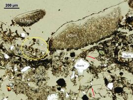
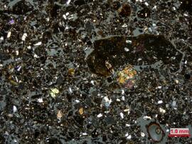
File consists of thin section micrograph images from the Boreal Cordilleran grassland soils study (2007 & 2008).
2023.2.2.12.7
·
File
·
2007-2008
Part of Dr. Paul Sanborn fonds
2023.2.2.12.6
·
File
·
2007-2008
Part of Dr. Paul Sanborn fonds
2023.2.2.10.2.8
·
File
·
Sept. 1995
Part of Dr. Paul Sanborn fonds
File contains 2 rolls (51 slides) taken September 25-26, 1995 that depict paired views of plot vegetation and forest floor surface. Handwritten number notations on slide frames indicate plot numbers from the original research installation.
2023.2.2.10.1.6
·
File
·
Aug. 1997
Part of Dr. Paul Sanborn fonds
File contains 8 slides from 2 rolls, taken August 1997:
Roll 1 - Buckhorn Ridge:
- Slide 31 – Fd (2 x 2 m) – stand view
- Slide 32 – Fd (2 x 2 m) – forest floor view
- Slide 33 – Pl (2x 2 m) – stand view
- Slide 34 – Pl (2 x 2 m) – forest floor view
Roll 2 – Bobtail Road: - Slide 20 – Pl (2 x 2 m) – east plot, stand view
- Slide 21 – Pl (2 x 2 m) – east plot, stand view
- Slide 22 – Fd (2 x 2 m) – east plot, stand view
- Slide 23 – Sw (2 x 2 m) – stand view
2022.03.01
·
File
·
1950-2005
Part of Stowell Forestry Collection
File contains photographs of The Pas Lumber Company Ltd. Includes other northern BC forestry industry images, including Number 5 Timber Ltd. CP625 Block 101, bridge construction, and heavy machinery. Also includes a graphic postcard of Prince George circa 1970s.
2020.4.6.601
·
File
·
2004
Part of G. Gary Runka fonds
File consists of records created and accumulated by Gary Runka over the course of his consultancy work for Grasslands Conservation Council of BC for the "Development of Strategic Plan for Mitigating Fragmentation and Development of BC's Grasslands" project in Kamloops. This file was numbered as G.G. Runka Land Sense Ltd. client file #601; that client number may be seen referenced elsewhere in the G. Gary Runka fonds. The Land Sense Ltd. client files generally include records such as correspondence, contracts, invoices, project reports, publications, ephemera, memoranda, maps or map excerpts, legal documents, meeting materials, clippings, and handwritten notes. File also includes 17 accompanying photographs.
2020.4.6.577
·
File
·
2002
Part of G. Gary Runka fonds
File consists of records created and accumulated by Gary Runka over the course of his consultancy work for Abbotsford Airport, Chris Raven for the "Assistance with Heliport Land Use Change Proposal Application" project in Abbotsford. This file was numbered as G.G. Runka Land Sense Ltd. client file #577; that client number may be seen referenced elsewhere in the G. Gary Runka fonds. The Land Sense Ltd. client files generally include records such as correspondence, contracts, invoices, project reports, publications, ephemera, memoranda, maps or map excerpts, legal documents, meeting materials, clippings, and handwritten notes. File also includes 13 accompanying photographs.
2020.4.6.571
·
File
·
2001
Part of G. Gary Runka fonds
File consists of records created and accumulated by Gary Runka over the course of his consultancy work for Little Beaver Creek Ranch, Glimpse Lake Ranch Estate Ltd. for the "Assistance with Ranch Tourism Land Use Application" project in Glimpse Lake. This file was numbered as G.G. Runka Land Sense Ltd. client file #571; that client number may be seen referenced elsewhere in the G. Gary Runka fonds. The Land Sense Ltd. client files generally include records such as correspondence, contracts, invoices, project reports, publications, ephemera, memoranda, maps or map excerpts, legal documents, meeting materials, clippings, and handwritten notes. File also includes 2 accompanying aerial photographs.
2020.4.6.556
·
File
·
2001
Part of G. Gary Runka fonds
File consists of records created and accumulated by Gary Runka over the course of his consultancy work for Land Conservancy of British Columbia for the "Penticton Indian Band Riparian Ecosystem Conservation Education Project in Penticton for En'Owkin Centre and Land Conservancy of BC on behalf of South Okanagan-Similkameen Conservation Program Habitat Securement Team" project in Penticton. This file was numbered as G.G. Runka Land Sense Ltd. client file #556; that client number may be seen referenced elsewhere in the G. Gary Runka fonds. The Land Sense Ltd. client files generally include records such as correspondence, contracts, invoices, project reports, publications, ephemera, memoranda, maps or map excerpts, legal documents, meeting materials, clippings, and handwritten notes. File also includes 93 accompanying photographs. Also includes an oversize enlargement of BC air photo 30BCC96045 No. 181.
2020.4.6.538
·
File
·
2000
Part of G. Gary Runka fonds
File consists of records created and accumulated by Gary Runka over the course of his consultancy work for Public Works Canada for the "Potential Environmental Impact of Proposed Irrigation Pipeline Easement on Federal Lands" project in Lytton. This file was numbered as G.G. Runka Land Sense Ltd. client file #538; that client number may be seen referenced elsewhere in the G. Gary Runka fonds. The Land Sense Ltd. client files generally include records such as correspondence, contracts, invoices, project reports, publications, ephemera, memoranda, maps or map excerpts, legal documents, meeting materials, clippings, and handwritten notes. File also includes 4 accompanying aerial photographs.
2020.4.6.535
·
File
·
2000
Part of G. Gary Runka fonds
File consists of records created and accumulated by Gary Runka over the course of his consultancy work for Nature Trust of British Columbia for the "Acquisition of Thomas Ranch Property near Vaseux Lake" project in Vaseux Lake. This file was numbered as G.G. Runka Land Sense Ltd. client file #535; that client number may be seen referenced elsewhere in the G. Gary Runka fonds. The Land Sense Ltd. client files generally include records such as correspondence, contracts, invoices, project reports, publications, ephemera, memoranda, maps or map excerpts, legal documents, meeting materials, clippings, and handwritten notes. File also includes 3 accompanying photographs.
Includes the following:
- Vaseux Conservation Strategy. Overall Plan Part 1 of 11. Prepared by K. Chapman et al. for Canadian Wildlife Service and The Nature Trust of British Columbia. 1997.
2020.4.6.534
·
File
·
1999
Part of G. Gary Runka fonds
File consists of records created and accumulated by Gary Runka over the course of his consultancy work for Hurstmount Farm for the "Consultation on Proposed Homesite Subdivision Associated with Purebred Angus Breeding Farm Operation" project in North Saanich. This file was numbered as G.G. Runka Land Sense Ltd. client file #534; that client number may be seen referenced elsewhere in the G. Gary Runka fonds. The Land Sense Ltd. client files generally include records such as correspondence, contracts, invoices, project reports, publications, ephemera, memoranda, maps or map excerpts, legal documents, meeting materials, clippings, and handwritten notes. File also includes 19 accompanying aerial photographs.
Includes map:
*Robert Ribic, "Hurstmount Farm 1405 Tatlow Rd." site plan, 1998.
2020.4.6.521
·
File
·
1999
Part of G. Gary Runka fonds
File consists of records created and accumulated by Gary Runka over the course of his consultancy work for Land Use Coordination Office for the "Facilitation and Mediation for Cassiar Iskut - Stikine Land and Resource Management Plan" project in Dease Lake. This file was numbered as G.G. Runka Land Sense Ltd. client file #521; that client number may be seen referenced elsewhere in the G. Gary Runka fonds. The Land Sense Ltd. client files generally include records such as correspondence, contracts, invoices, project reports, publications, ephemera, memoranda, maps or map excerpts, legal documents, meeting materials, clippings, and handwritten notes. File also includes 4 accompanying photographs.
Includes the following:
- Cassiar-Iskut-Stikine Land and Resource Management Plan Information Analysis and Inventory Handbook, Undated; Consensus Recommendations Package, April 2000 and Resource Management Plan. Prince Rupert Inter-Agency Management Committee. Smithers. October 2000.
- Cassiar Timber Supply Area Timber Supply Review Data Package. BC Min. of Forests. 1999.
- Cassiar-Iskut-Stikine Land and Resource Management Plan. Briefing Paper. Friends of the Stikine. 2000.
2020.4.6.518
·
File
·
1999
Part of G. Gary Runka fonds
File consists of records created and accumulated by Gary Runka over the course of his consultancy work for Nature Trust of British Columbia for the "Coordination and Planning Approach for Biodiversity Ranches" project in White Lake Basin. This file was numbered as G.G. Runka Land Sense Ltd. client file #518; that client number may be seen referenced elsewhere in the G. Gary Runka fonds. The Land Sense Ltd. client files generally include records such as correspondence, contracts, invoices, project reports, publications, ephemera, memoranda, maps or map excerpts, legal documents, meeting materials, clippings, and handwritten notes. File also includes 17 accompanying photographs and audio cassette recordings of meetings. Also includes a 1996 oversize colour air photograph of "White Lake - Vaseux Lake Ranch Land Conservation Project".
Maps include:
- BC Forest Service, "Range Use Plan, White Lake Basin", June 1999.
- BC Forest Service, "Range Use Plan, White Lake Basin", June 1999 - annotated with pasture names and areas.
- BC Forest Service, "Range Use Plan, White Lake Basin", Jan. 1999 - hand annotated with pasture outlines and notes.
- Photocopy of BC Forest Service, "Range Use Plan, White Lake Basin", June 1999 - hand annotated.
- BC Land Use Coordination Office, "Potential Biodiversity Ranches", Sept. 1999. (6 copies)
2020.4.6.509
·
File
·
1998
Part of G. Gary Runka fonds
File consists of records created and accumulated by Gary Runka over the course of his consultancy work for B. & V. Prokopetz for the "ALCA Application for Subdivision" project in Terrace, BC. This file was numbered as G.G. Runka Land Sense Ltd. client file #509; that client number may be seen referenced elsewhere in the G. Gary Runka fonds. The Land Sense Ltd. client files generally include records such as correspondence, contracts, invoices, project reports, publications, ephemera, memoranda, maps or map excerpts, legal documents, meeting materials, clippings, and handwritten notes. File also includes 22 accompanying photographs.
2020.4.6.508
·
File
·
1998
Part of G. Gary Runka fonds
File consists of records created and accumulated by Gary Runka over the course of his consultancy work for BC Buildings Corporation for the "Land Use Options Planning and ALR Inclusion/Exclusion Applications for former Twin Maples Correctional Centre" project in Ruskin. This file was numbered as G.G. Runka Land Sense Ltd. client file #508; that client number may be seen referenced elsewhere in the G. Gary Runka fonds. The Land Sense Ltd. client files generally include records such as correspondence, contracts, invoices, project reports, publications, ephemera, memoranda, maps or map excerpts, legal documents, meeting materials, clippings, and handwritten notes. File also includes 48 accompanying photographs. Also includes three oversize 1997 annotations air photographs, one which also has an overlay showing land use annotations.
Maps include:
- Corporation of the District of Maple Ridge topographical map, 1995.
- Photocopy of map with overlay by G.G. Runka Land Sense Ltd., "Map 2: Land Capability for Agriculture", showing annotations on top of photomap, 1994.
- Hobbs, Winter & MacDonald B.C. Land Surveyors, "Subivision Plan of the North West Quarter of Section 4, Township 15 and the North East Quarter of Section 4, Township 15 except: firstly: South East 30 Acres Having a Frontage of 15 Chains on the South Boundary by 20 Chains on the East Boundary of Quarter Section; Secondly: Part Subdivided by Plan 13294, New Westminster District", B.C.G.S. 92G 018, 1999. (5 copies)
2020.4.6.498
·
File
·
1998
Part of G. Gary Runka fonds
File consists of records created and accumulated by Gary Runka over the course of his consultancy work for Agricultural Land Commission for the "Review of ALR and Proposed CCRD Official Community Plan Residential Settlement and Industrial Designation" project in Hagensborg. This file was numbered as G.G. Runka Land Sense Ltd. client file #498; that client number may be seen referenced elsewhere in the G. Gary Runka fonds. The Land Sense Ltd. client files generally include records such as correspondence, contracts, invoices, project reports, publications, ephemera, memoranda, maps or map excerpts, legal documents, meeting materials, clippings, and handwritten notes. File also includes 9 accompanying aerial photographs.
2020.4.6.491
·
File
·
1998
Part of G. Gary Runka fonds
File consists of records created and accumulated by Gary Runka over the course of his consultancy work for Anahim Lake Round Table for the "Charlotte-Alplands Wilderness Tourism and Forest Recreation Opportunities Study" project in West Chilcotin. This file was numbered as G.G. Runka Land Sense Ltd. client file #491; that client number may be seen referenced elsewhere in the G. Gary Runka fonds. The Land Sense Ltd. client files generally include records such as correspondence, contracts, invoices, project reports, publications, ephemera, memoranda, maps or map excerpts, legal documents, meeting materials, clippings, and handwritten notes. File also includes 32 accompanying photographs.
Includes the following:
- Anahim Round Table Sub Regional Plan: Report of Objectives and Strategies. Recommended Options. 2000.
Maps include:
- G.G. Runka Land Sense Ltd. and Shearwater Mapping Ltd., "Charlotte-Alplands Snow Based Wilderness Tourism Product Capability Map", March 1998.
- G.G. Runka Land Sense Ltd. and Shearwater Mapping Ltd., "Charlotte-Alplands Land Based Wilderness Tourism Product Capability Map", March 1998.
- G.G. Runka Land Sense Ltd. and Shearwater Mapping Ltd., "Charlotte-Alplands Water Based Wilderness Tourism Product Capability Map", March 1998.
- G.G. Runka Land Sense Ltd. and Shearwater Mapping Ltd., "Charlotte-Alplands Biogeoclimatic Based Wilderness Tourism Product Capability Map", March 1998.
- Photocopy of map of Fraser Plateau with overlap depicting Hwy 20 corridor, Hotnarko LRUP, and other areas, n.d. (3 copies, various sizes)
- Combination of NTS maps joined together and annotated to show the Fraser Plateau area, n.d.
- Combination of NTS maps joined together and annotated to show the Coast Mountains Pacific Ranges area, n.d.
- G.G. Runka Land Sense Ltd., "Land Based Tourism Product Capability, Map Sheet 3" hand drawn annotations on printed base map, c. 1998.
- G.G. Runka Land Sense Ltd., "Land Based Tourism Product Capability, Map Sheet 2" hand drawn annotations on printed base map, c. 1998.
- G.G. Runka Land Sense Ltd., "Land Based Tourism Product Capability, Map Sheet 1" hand drawn annotations on printed base map, c. 1998.
- G.G. Runka Land Sense Ltd., "Snow Based Tourism Product Capability, Map Sheet 3" hand drawn annotations on printed base map, c. 1998.
- G.G. Runka Land Sense Ltd., "Snow Based Tourism Product Capability, Map Sheet 2" hand drawn annotations on printed base map, c. 1998.
- G.G. Runka Land Sense Ltd., "Snow Based Tourism Product Capability, Map Sheet 1" hand drawn annotations on printed base map, c. 1998.
- Topographical map of Charlotte Lake area, n.d.
- Topographical map of Charlotte Lake area with hand-drawn annotations, n.d. (3 copies with different annotations)
- Topographical map of Crazy Bear (Ginny) Lake area with hand-drawn annotations, n.d. (2 copies with different annotations)
- Topographical map of Bussel Creek and Fraser Plateau area with hand-drawn annotations, n.d. (2 copies with different annotations)
- Topographical map of Banana Lake area, n.d.
- Topographical map of Banana Lake area with hand-drawn annotations, n.d. (3 copies with different annotations)
- Hand-drawn and coloured map showing alpine flower meadows, lakes, hiking trails, and the alpine tundra boundary in Mt McClinchy area, n.d.
- G.G. Runka Land Sense Ltd., "Wildlife Presence", n.d.
- B.C. Forest Service, "Recreation Resource Inventory" 92N.083, 1993.
- B.C. Forest Service, "ART [Anahim Round Table] Interest Area, Access Management Plan" draft version, Nov. 1997
- BC Ministry of Forests, "Highway 20 #4, Chilcotin Forest District Landscape Inventory & Analysis Legend", mapsheets 92N 084-86, 094-96, 93C 003-06
- BC Ministry of Forests, "Highway 20 #5, Chilcotin Forest District Landscape Inventory & Analysis Legend", mapsheets 93C 013-15, 023-026, 033-35
- L.A. West Landscape Architects Environmental Planners, "Chilcotin Forest District, Visually Sensitive Area Inventory", Feb. 1994
- Photocopy of annotations on 93C.012-13 base map
- Photocopy of annotations on 93C.004 base map
- Photocopy of annotations on Charlotte-Alplands base map
- "Anahim Round Table Interest Area Geographical Units" annotated on combined NTS maps
2020.4.6.429
·
File
·
1996
Part of G. Gary Runka fonds
File consists of records created and accumulated by Gary Runka over the course of his consultancy work for Nadleh Whut'en Indian Band for the "Forage Land Value Assessment for Lejac Residential School Property" project in Fraser Lake. This file was numbered as G.G. Runka Land Sense Ltd. client file #429; that client number may be seen referenced elsewhere in the G. Gary Runka fonds. The Land Sense Ltd. client files generally include records such as correspondence, contracts, invoices, project reports, publications, ephemera, memoranda, maps or map excerpts, legal documents, meeting materials, clippings, and handwritten notes. File also includes 3 accompanying aerial photographs.
Maps include:
- M.E.C., "Preliminary Plan of Lejac School Site, Seaspunkut I.R. No. 4", July 1973.
- Energy, Mines and Resources Canada Surveys and Mapping Branch, "Survey Overlay Photomap of Seaspunkut I.R. No. 4, Range 5, Coast District, British Columbia", scale 5000, NTS map sheet 93K/2, Nov. 1992.
2020.4.6.426
·
File
·
1996
Part of G. Gary Runka fonds
File consists of records created and accumulated by Gary Runka over the course of his consultancy work for Department of Indian Affairs and Northern Development, Specific Claims West for the "An Overview of Former Commonage Rangeland Characteristics for Summerland" project in Summerland. This file was numbered as G.G. Runka Land Sense Ltd. client file #426; that client number may be seen referenced elsewhere in the G. Gary Runka fonds. The Land Sense Ltd. client files generally include records such as correspondence, contracts, invoices, project reports, publications, ephemera, memoranda, maps or map excerpts, legal documents, meeting materials, clippings, and handwritten notes. File also includes 60 accompanying aerial photographs.
Maps include:
- "Map 11: Summerland Commonage Topographic Map 1:50,000", n.d.
- "Map 12: Summerland Commonage 1:100,000 Soils map", n.d.
- "Map 13: Summerland Commonage Biogeoclimatic Map 1:100,000", n.d.
- "Map 14: Summerland Commonage Land Capability for Agriculture (Improved) 1:50,000", n.d.
- "Map 15: Summerland Commonage Agricultural Land Reserve Map 1:50,000", n.d.
- "Map 16: Summerland Commonage Grazing Tenure Map 1:100,000", n.d.
2020.4.6.425
·
File
·
1996
Part of G. Gary Runka fonds
File consists of records created and accumulated by Gary Runka over the course of his consultancy work for Department of Indian Affairs and Northern Development, Specific Claims West for the "An Overview of Former Commonage Rangeland Characteristics for Vernon" project in Vernon Commonage. This file was numbered as G.G. Runka Land Sense Ltd. client file #425; that client number may be seen referenced elsewhere in the G. Gary Runka fonds. The Land Sense Ltd. client files generally include records such as correspondence, contracts, invoices, project reports, publications, ephemera, memoranda, maps or map excerpts, legal documents, meeting materials, clippings, and handwritten notes. File also includes 39 accompanying aerial photographs.
Maps include:
- "Map 6: Vernon Commonage Topographic Map 1:50,000", n.d.
- "Map 7: Vernon Commonage 1:100,000 Soils map", n.d.
- "Map 8: Vernon Commonage Biogeoclimatic Map 1:100,000", n.d.
- "Map 9: Vernon Commonage Land Capability for Agriculture (Improved) 1:50,000", n.d.
- "Map 10: Vernon Commonage Agricultural Land Reserve Map 1:50,000", n.d.
2020.4.6.424
·
File
·
1996
Part of G. Gary Runka fonds
File consists of records created and accumulated by Gary Runka over the course of his consultancy work for Department of Indian Affairs and Northern Development, Specific Claims West for the "Livestock Range Suitability Assessment for Douglas Lake Commonage Study" project in Douglas Lake. This file was numbered as G.G. Runka Land Sense Ltd. client file #424; that client number may be seen referenced elsewhere in the G. Gary Runka fonds. The Land Sense Ltd. client files generally include records such as correspondence, contracts, invoices, project reports, publications, ephemera, memoranda, maps or map excerpts, legal documents, meeting materials, clippings, and handwritten notes. File also includes 32 accompanying aerial photographs.
Maps include:
- "Crown Range Areas of the Nicola Stock Range (Douglas Lake Cattle Co.) - east", n.d.
- "Crown Range Areas of the Nicola Stock Range (Douglas Lake Cattle Co.) - west", n.d.
- "Map 1: Douglas Lake Commonage Topographic Map 1:50,000", n.d.
- "Map 2: Douglas Lake Commonage 1:100,000 Soils map", n.d.
- "Map 3: Douglas Lake Commonage Land Capability for Agriculture (Improved) 1:50,000", n.d.
- "Map 4: Douglas Lake Commonage Biogeoclimatic Map 1:100,000", n.d.
- "Map 5: Douglas Lake Commonage Agricultural Land Reserve Map 1:50,000", n.d.
2020.4.6.406
·
File
·
1995
Part of G. Gary Runka fonds
File consists of records created and accumulated by Gary Runka over the course of his consultancy work for Salmon River Watershed Roundtable for the "An Overview of Salmon River Watershed Land and Water Resources Condition, Trends and Issues" project in Salmon Arm. This file was numbered as G.G. Runka Land Sense Ltd. client file #406; that client number may be seen referenced elsewhere in the G. Gary Runka fonds. The Land Sense Ltd. client files generally include records such as correspondence, contracts, invoices, project reports, publications, ephemera, memoranda, maps or map excerpts, legal documents, meeting materials, clippings, and handwritten notes. File also includes 12 accompanying photographs.
2020.4.6.376
·
File
·
1994
Part of G. Gary Runka fonds
File consists of records created and accumulated by Gary Runka over the course of his consultancy work for Spallumcheen Indian Band, Pape & Salter for the "Review of Impact and Future Use of Hydro Right of Way Land by Spallumcheen Indian Band" project in Spallumcheen. This file was numbered as G.G. Runka Land Sense Ltd. client file #376; that client number may be seen referenced elsewhere in the G. Gary Runka fonds. The Land Sense Ltd. client files generally include records such as correspondence, contracts, invoices, project reports, publications, ephemera, memoranda, maps or map excerpts, legal documents, meeting materials, clippings, and handwritten notes. File also includes 32 accompanying aerial photographs.
Includes the following:
- Land Use and Impact BC Hydro Right-of-Way Enderby Indian Reserve #2. Prepared by G.G. Runka Land Sense Ltd. for Spallumcheen Indian Band Negotiating Team. 1995.
Maps include:
- Terra Engineering Ltd. for Spallumcheen Indian Band, "Enderby Gravel Pit, Depth to Bedrock", sheet 2 of 3, Jan. 1995.
- Terra Engineering Ltd. for Spallumcheen Indian Band, "Enderby Gravel Pit, Bedrock Surface", sheet 3 of 3, Jan. 1995.
- Energy, Mines and Resources Canada Surveys and Mapping Branch, "General Purpose Photomap Survey Overlay Photomap of Enderby I.R. No. 2, Kamloops Division of Yale District, British Columbia", sheet 1 of 1, scale 1:10000, NTS map sheet 82L/11, Aug. 1992. (2 copies)
- Energy, Mines and Resources Canada Surveys and Mapping Branch, "Survey Overlay Photomap of Enderby I.R. No. 2, Kamloops Division of Yale District, British Columbia", sheet 1 of 3, scale 1:5000, NTS map sheet 82L, Sept. 1993. (2 copies)
- Energy, Mines and Resources Canada Surveys and Mapping Branch, "Survey Overlay Photomap of Enderby I.R. No. 2, Kamloops Division of Yale District, British Columbia", sheet 2 of 3, scale 1:5000, NTS map sheet 82L, Sept. 1993. (2 copies)
- Energy, Mines and Resources Canada Surveys and Mapping Branch, "Survey Overlay Photomap of Enderby I.R. No. 2, Kamloops Division of Yale District, British Columbia", sheet 3 of 3, scale 1:5000, NTS map sheet 82L, Sept. 1993. (2 copies)
- Energy, Mines and Resources Canada Surveys and Mapping Branch, "Photomap of Enderby I.R. No. 2, Kamloops Division of Yale District, British Columbia", sheet 3 of 3, scale 1:5000, NTS map sheet 82L, n.d.
- G.G. Runka Land Sense Ltd., overlay for "Survey Overlay Photomap of Enderby I.R. No. 2", sheet 1 of 3, July 1995.
- G.G. Runka Land Sense Ltd., print reproduction of overlay for "Survey Overlay Photomap of Enderby I.R. No. 2", sheet 1 of 3, July 1995.
- G.G. Runka Land Sense Ltd., overlay for "Survey Overlay Photomap of Enderby I.R. No. 2", sheet 2 of 3, July 1995.
- G.G. Runka Land Sense Ltd., print reproduction of overlay for "Survey Overlay Photomap of Enderby I.R. No. 2", sheet 2 of 3, July 1995.
- G.G. Runka Land Sense Ltd., overlay for "Survey Overlay Photomap of Enderby I.R. No. 2", sheet 3 of 3, July 1995.
- G.G. Runka Land Sense Ltd., print reproduction of overlay for "Survey Overlay Photomap of Enderby I.R. No. 2", sheet 3 of 3, July 1995.
- Energy, Mines and Resources Canada Surveys and Mapping Branch, "Survey Overlay Enderby I.R. No. 2, Kamloops Division of Yale District, British Columbia", sheet 1 of 3, scale 1:5000, NTS map sheet 82L, [1995?] - annotated
- Energy, Mines and Resources Canada Surveys and Mapping Branch, "Survey Overlay Enderby I.R. No. 2, Township 18, Ranges 8 and 9, W. 6 M., District of Kamloops, British Columbia", sheet # of 3, scale 1:5000, NTS map sheet 82L, n.d. - annotated
- Energy, Mines and Resources Canada Surveys and Mapping Branch, "Reference Plan of Enderby I.R. No. 2, Kamloops Division of Yale District, British Columbia", scale 1:10,000, NTS map sheet 82L/11E, revised to August 1992. (3 copies)
- Reproduction of BC Hydro and Power Authority, "Plan and Field Notes of Survey of Transmission Line Right of Way through a part of Enderby Indian Reserve No. 2 TP. 18 Rge. 8 and 9 W. 6M., Kamloops Division Yale District, Province of British Columbia", 1976
- Reproduction of BC Hydro drawing No. 300-T07-X15 showing transmission line through Enderby Indian Reserve No. 2", n.d.
- Reproduction of BC Hydro drawing showing transmission line through Enderby Indian Reserve No. 2", n.d.
- Reproduction of BC Hydro Structure Location Plan 300-T07-X16 drawn on top of "Field Notes of Survey of Transmission Line Right of Way through Part of Enderby Indian Reserve No. 2 TP. 18, R. 8 and 9, W 6th Mer., Kamloops Division, Yale District, Province of British Columbia", 1976. (4 copies)
- Reproduction of BC Hydro Structure Location Plan 300-T07-X17 drawn on top of "Plan and Field Notes of Survey of Transmission Line Right of Way through Part of Enderby Indian Reserve No. 2 TP. 18, R. 8 and 9, W 6th Mer., Kamloops Division, Yale District, Province of British Columbia", 1976. (5 copies)
- Reproduction of "Plan and Field Notes of Survey of Transmission Line Right of Way through Part of Enderby Indian Reserve No. 2 TP. 18, R. 8 and 9, W 6th Mer., Kamloops Division, Yale District, Province of British Columbia", Jan. 1976.
- BC Ministry of Crown Lands, "82L.055 Digital", n.d.