Previsualizar a impressão Fechar
Mostrar 973 resultados
Archival description
Upper Nass Assessment Project map sheets
Upper Nass Assessment Project map sheets
"Spatsizi Provincial Park Key Map"
"Spatsizi Provincial Park Key Map"
"Impact of Kemano Expansion on Gitksan-Wet'suwet'en Fishery"
"Impact of Kemano Expansion on Gitksan-Wet'suwet'en Fishery"
Capability classification for Bowser Lake
Capability classification for Bowser Lake
"Preliminary Environmental Assessment of Corridor Alternatives for the Proposed Mount Klappan Coal Project"
"Preliminary Environmental Assessment of Corridor Alternatives for the Proposed Mount Klappan Coal Project"
"Preliminary Wildlife Assessment of Klappan Coal Road Alternatives"
"Preliminary Wildlife Assessment of Klappan Coal Road Alternatives"
"Mount Klappan Access Road Study"
"Mount Klappan Access Road Study"
"Mount Klappan Anthracite Project"
"Mount Klappan Anthracite Project"
"Preliminary Environmental Assessment of Railway Corridor Options to Service Mount Klappan Coal Project and the Northwest Region of British Columbia"
"Preliminary Environmental Assessment of Railway Corridor Options to Service Mount Klappan Coal Project and the Northwest Region of British Columbia"
"Task Force on Northwest Economic Development Opportunities - Environmental Overview - Technical Background Report"
"Task Force on Northwest Economic Development Opportunities - Environmental Overview - Technical Background Report"
Upper Nass Assessment Project notes and correspondence
Upper Nass Assessment Project notes and correspondence
Upper Nass Assessment Project planning
Upper Nass Assessment Project planning
Kalum Forest District SBFEP Forest Development Plan, 1997-2001
Kalum Forest District SBFEP Forest Development Plan, 1997-2001
"Biological Investigation Report - Gosling Creek"
"Biological Investigation Report - Gosling Creek"
"Documentation of 'Noname Creek' [Station 13 + 500] on Fiddler Mainline forest road as suitable habitat for supporting Tailed Frogs [Ascaphus truei], a Blue Listed species in British Columbia"
"Documentation of 'Noname Creek' [Station 13 + 500] on Fiddler Mainline forest road as suitable habitat for supporting Tailed Frogs [Ascaphus truei], a Blue Listed species in British Columbia"
"Extending the Known Range of Tailed Frog Populations in British Columbia"
"Extending the Known Range of Tailed Frog Populations in British Columbia"
"Sampling Techniques for the Tailed Frog and the Pacific Giant Salamander" (draft)
"Sampling Techniques for the Tailed Frog and the Pacific Giant Salamander" (draft)
"Tailed Frog Habitat and Population Monitoring - Year 3 - 1996"
"Tailed Frog Habitat and Population Monitoring - Year 3 - 1996"
Muskwa-Kechika project slides
Muskwa-Kechika project slides
Muskwa-Kechika project digital images
Muskwa-Kechika project digital images

Muskwa-Kechika soils and prescribed burning project data
Kluane Lake 2009 field work photographs
Kluane Lake 2009 field work photographs
Kluane Lake 2004 photographs - print roll 13
Kluane Lake 2004 photographs - print roll 13
Kluane Lake 2004 photographs - print roll 12
Kluane Lake 2004 photographs - print roll 12
Kluane Lake 2004 photographs - print roll 11
Kluane Lake 2004 photographs - print roll 11
Kluane Lake 2004 photographs - print roll 10
Kluane Lake 2004 photographs - print roll 10
Kluane Lake 2004 photographs - slide roll 7
Kluane Lake 2004 photographs - slide roll 7
Kluane Lake 2004 photographs - slide roll 6
Kluane Lake 2004 photographs - slide roll 6
Kluane Lake 2003 photographs - digital photographs
Kluane Lake 2003 photographs - digital photographs
Kluane Lake 2003 photographs - print roll 5
Kluane Lake 2003 photographs - print roll 5
Kluane Lake 2003 photographs - print roll 4
Kluane Lake 2003 photographs - print roll 4
Kluane Lake 2003 photographs - print roll 3
Kluane Lake 2003 photographs - print roll 3
Kluane Lake 2003 photographs - slide roll 4
Kluane Lake 2003 photographs - slide roll 4
Kluane Lake 2003 photographs - slide roll 3
Kluane Lake 2003 photographs - slide roll 3
Kluane Lake 2003 photographs - slide roll 2
Kluane Lake 2003 photographs - slide roll 2

Kluane Lake soils research data
Fort Selkirk volcanic field images
Fort Selkirk volcanic field images

Fort Selkirk volcanic field soil reconnaissance data
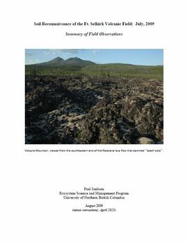
"Soil Reconnaissance of the Ft. Selkirk Volcanic Field: July, 2009 - Summary of Field Observations"
Air photographs of Fort Selkirk volcanic field, Yukon
Air photographs of Fort Selkirk volcanic field, Yukon
Yukon Paleosol Study topographical NTS map scans
Yukon Paleosol Study topographical NTS map scans

Wounded Moose geochemistry paleosol data for Yukon Paleosol Study
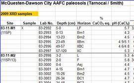
McQuesten-Dawson City paleosol data for Yukon Paleosol Study
Tarnocai and Smith lab data sheets for Yukon Paleosol Study soil samples
Tarnocai and Smith lab data sheets for Yukon Paleosol Study soil samples
Tarnocai and Smith Yukon Paleosol Study (1983) soil description forms
Tarnocai and Smith Yukon Paleosol Study (1983) soil description forms
Photographs from Lost Chicken Mine
Photographs from Lost Chicken Mine
Soil data file detail forms for Lost Chicken mine locations
Soil data file detail forms for Lost Chicken mine locations
Photographs from Mackenzie Mountains & Mackenzie valley, NWT
Photographs from Mackenzie Mountains & Mackenzie valley, NWT
Photographs from Gold Bottom paleosols study
Photographs from Gold Bottom paleosols study
Slides from Arocena & Sanborn 1999 regional soil mineralogy study
Slides from Arocena & Sanborn 1999 regional soil mineralogy study