Print preview Close
Showing 49 results
Archival description
Remove filter:
Dr. Paul Sanborn fonds
Remove filter:
Bestanddeel
Remove filter:
Science and Technology
Data for "Effects of Prescribed Fire on Sulphur in Forest Soils" project
Tarnocai and Smith Yukon Paleosol Study (1983) soil description forms
Tarnocai and Smith Yukon Paleosol Study (1983) soil description forms
Air photographs of Fort Selkirk volcanic field, Yukon
Air photographs of Fort Selkirk volcanic field, Yukon

Fort Selkirk volcanic field soil reconnaissance data
Kluane Lake 2004 photographs - print roll 11
Kluane Lake 2004 photographs - print roll 11
Kluane Lake 2009 field work photographs
Kluane Lake 2009 field work photographs
Archie Creek slides
Archie Creek slides
Grassland soils in the Boreal Cordillera Ecozone study data
Klutlan Glacier soils study data
Klutlan Glacier soils study images: Soil and site views
Klutlan Glacier soils study images: Soil and site views
Soil data file detail forms for Lost Chicken mine locations
Soil data file detail forms for Lost Chicken mine locations
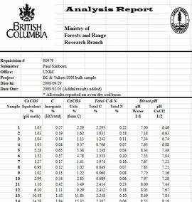
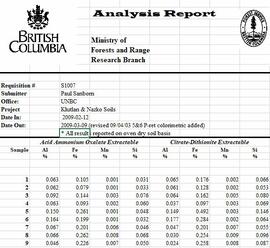
Tarnocai and Smith lab data sheets for Yukon Paleosol Study soil samples
Tarnocai and Smith lab data sheets for Yukon Paleosol Study soil samples
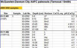
McQuesten-Dawson City paleosol data for Yukon Paleosol Study

Kluane Lake soils research data
Kluane Lake 2003 photographs - print roll 5
Kluane Lake 2003 photographs - print roll 5
Kluane Lake 2004 photographs - print roll 10
Kluane Lake 2004 photographs - print roll 10
Muskwa-Kechika project digital images
Muskwa-Kechika project digital images
Experimental Project (EP) 660 slides
Experimental Project (EP) 660 slides
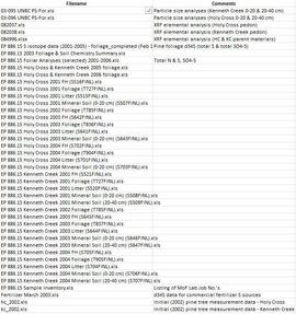
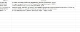
Data for Sulphur stable isotope tracer study (E.P. 886.15)
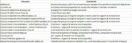
Data from Arocena & Sanborn 1999 regional soil mineralogy study
Photographs from Mackenzie Mountains & Mackenzie valley, NWT
Photographs from Mackenzie Mountains & Mackenzie valley, NWT
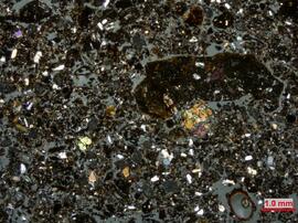
Grassland soils in the Boreal Cordillera Ecozone study images: Thin section micrographs
Fort Selkirk volcanic field images
Fort Selkirk volcanic field images
Kluane Lake 2003 photographs - slide roll 3
Kluane Lake 2003 photographs - slide roll 3
Kluane Lake 2003 photographs - digital photographs
Kluane Lake 2003 photographs - digital photographs
Kluane Lake 2004 photographs - print roll 12
Kluane Lake 2004 photographs - print roll 12
Kluane Lake 2004 photographs - print roll 13
Kluane Lake 2004 photographs - print roll 13
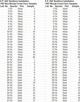
Experimental Project (EP) 660 data
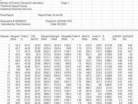
Archie Creek site data
Grassland soils in the Boreal Cordillera Ecozone study images: Landscape overviews
Grassland soils in the Boreal Cordillera Ecozone study images: Landscape overviews
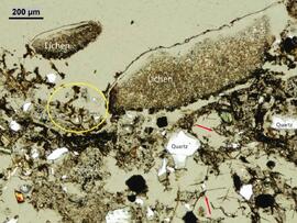
Klutlan Glacier soils study images: Thin section micrographs
Data for Cluculz retrospective study (E.P. 886.10)
Slides from Arocena & Sanborn 1999 regional soil mineralogy study
Slides from Arocena & Sanborn 1999 regional soil mineralogy study
Photographs from Gold Bottom paleosols study
Photographs from Gold Bottom paleosols study
Photographs from Lost Chicken Mine
Photographs from Lost Chicken Mine

Wounded Moose geochemistry paleosol data for Yukon Paleosol Study
Yukon Paleosol Study topographical NTS map scans
Yukon Paleosol Study topographical NTS map scans
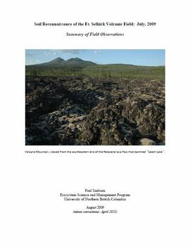
"Soil Reconnaissance of the Ft. Selkirk Volcanic Field: July, 2009 - Summary of Field Observations"
Kluane Lake 2003 photographs - slide roll 2
Kluane Lake 2003 photographs - slide roll 2
Kluane Lake 2003 photographs - slide roll 4
Kluane Lake 2003 photographs - slide roll 4
Kluane Lake 2003 photographs - print roll 3
Kluane Lake 2003 photographs - print roll 3
Kluane Lake 2003 photographs - print roll 4
Kluane Lake 2003 photographs - print roll 4
Kluane Lake 2004 photographs - slide roll 6
Kluane Lake 2004 photographs - slide roll 6
Kluane Lake 2004 photographs - slide roll 7
Kluane Lake 2004 photographs - slide roll 7

Muskwa-Kechika soils and prescribed burning project data
Muskwa-Kechika project slides
Muskwa-Kechika project slides
Experimental Project 1148 data
Grassland soils in the Boreal Cordillera Ecozone study images: Site and soil views
Grassland soils in the Boreal Cordillera Ecozone study images: Site and soil views
Klutlan Glacier soils study images: Aerial views
Klutlan Glacier soils study images: Aerial views