2023.2.2.14
·
Subseries
·
2022-2024
Part of Dr. Paul Sanborn fonds
10 results with digital objects
Show results with digital objects
2023.2.2.7
·
Subseries
·
2009-2010, 2023
Part of Dr. Paul Sanborn fonds
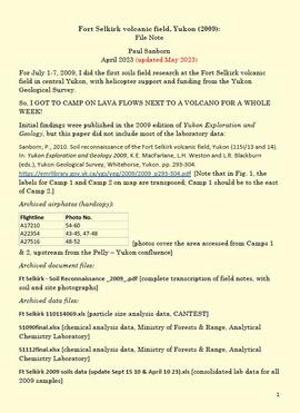
For July 1-7, 2009, Dr. Paul Sanborn did the first soils field research at the Fort Selkirk volcanic field in central Yukon, with helicopter support and funding from the Yukon Geological Survey.
Initial findings were published in the 2009 edition of Yukon Exploration and Geology, but this paper did not include most of the laboratory data:
Sanborn, P., 2010. Soil reconnaissance of the Fort Selkirk volcanic field, Yukon (115I/13 and 14). In: Yukon Exploration and Geology 2009, K.E. MacFarlane, L.H. Weston and L.R. Blackburn (eds.), Yukon Geological Survey, Whitehorse, Yukon. pp. 293-304. https://emrlibrary.gov.yk.ca/ygs/yeg/2009/2009_p293-304.pdf [Note that in Fig. 1, the labels for Camp 1 and Camp 2 on map are transposed; Camp 1 should be to the east of Camp 2.]

2023.2.2.5
·
Subseries
·
1991-2023, predominant 2004
Part of Dr. Paul Sanborn fonds
The Lost Chicken Mine, a placer gold mine in eastern Alaska, approximately 120 km west of Dawson City, Yukon, is an important fossil locality for the late Pliocene (approximately 2.5 – 3.0 million years ago). A comprehensive account of the stratigraphy and paleontology of this site was given by:
Matthews, J.V., Jr., J.A. Westgate, L. Ovenden, L.D. Carter, and T. Fouch. 2003. Stratigraphy, fossils, and age of sediments at the upper pit of the Lost Chicken gold mine: new information on the late Pliocene environment of east central Alaska. Quaternary Research 60: 9-18. https://doi.org/10.1016/S0033-5894(03)00087-5
Dr. Paul Sanborn visited the site on July 20, 2004, as part of a group led by Duane Froese (Professor, University of Alberta). The group concentrated on a single exposure (~ 2 m thick) straddling the Lost Chicken tephra, a volcanic ash bed (2.9 ± 0.4 myr) which is a major stratigraphic marker at the site. Sanborn described, photographed, and sampled this exposure, and obtained a basic set of characterization data. Intact samples were collected but thin sections were never produced.
2023.2.2.8
·
Subseries
·
2003-2014
Part of Dr. Paul Sanborn fonds
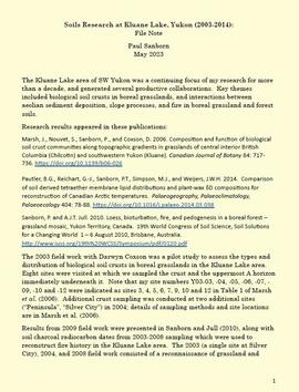
The Kluane Lake area of SW Yukon was a continuing focus of Dr. Paul Sanborn's research for more than a decade, and generated several productive collaborations. Key themes included biological soil crusts in boreal grasslands, and interactions between aeolian sediment deposition, slope processes, and fire in boreal grassland and forest soils.
Research results appeared in these publications:
Marsh, J., Nouvet, S., Sanborn, P., and Coxson, D. 2006. Composition and function of biological soil crust communities along topographic gradients in grasslands of central interior British Columbia (Chilcotin) and southwestern Yukon (Kluane). Canadian Journal of Botany 84: 717-736. https://doi.org/10.1139/b06-026
Pautler, B.G., Reichart, G.-J., Sanborn, P.T., Simpson, M.J., and Weijers, J.W.H. 2014. Comparison of soil derived tetraether membrane lipid distributions and plant-wax δD compositions for reconstruction of Canadian Arctic temperatures. Palaeogeography, Palaeoclimatology, Palaeoecology 404: 78-88. https://doi.org/10.1016/j.palaeo.2014.03.038
Sanborn, P. and A.J.T. Jull. 2010. Loess, bioturbation, fire, and pedogenesis in a boreal forest – grassland mosaic, Yukon Territory, Canada. 19th World Congress of Soil Science, Soil Solutions for a Changing World 1 – 6 August 2010, Brisbane, Australia. http://www.iuss.org/19th%20WCSS/Symposium/pdf/0120.pdf
The 2003 field work with Darwyn Coxson was a pilot study to assess the types and distribution of biological soil crusts in boreal grasslands in the Kluane Lake area. Eight sites were visited at which the team sampled the crust and the uppermost A horizon immediately underneath it. Note that site numbers Y03-03, -04, -05, -06, -07, -09, -10 and -12 were indicated as sites 3, 4, 5, 6, 7, 9, 10 and 12 in Table 1 of Marsh et al. (2006). Additional crust sampling was conducted at two additional sites (“Peninsula”, “Silver City”) in 2004; details of sampling methods and site locations are in Marsh et al. (2006).
Results from 2009 field work were presented in Sanborn and Jull (2010), along with soil charcoal radiocarbon dates from 2003-2008 sampling which were used to reconstruct fire history in the Kluane Lake area. The 2003 (a single site at Silver City), 2004, and 2008 field work consisted of a reconnaissance of grassland and forest sites across a range of aspects and slope positions in order to recover buried soil charcoal.
2013.6.36.2
·
Subseries
·
1960-2013
Part of David Davies Railway Collection
Subseries consists of prints and negatives depicting railways in British Columbia separated from the textual records of the David Davies Railway Collection.
2013.6.36.1
·
Subseries
·
1957-2013
Part of David Davies Railway Collection
Subseries consists of prints and negatives depicting railways in British Columbia, as well as a small selection of other subjects such as historical ships, buildings, vehicles, and bridges. All photographs created by David Davies.
2013.6.36.3
·
Subseries
·
1900-2013
Part of David Davies Railway Collection
Subseries consists of printed and photograph postcards depicting railways, buildings, ships, and other transportation in British Columbia.
2020.4.8.1
·
Subseries
·
1968-2013
Part of G. Gary Runka fonds
Gary Runka was a hobbyist photographer and documented his work and personal life through photography as he travelled across every region of British Columbia. This slide collection documents the evolution of British Columbia communities and regions over a 30 year period. Gary Runka's core interest was land and changing land uses. Many of these slides tell a story of urban edge and/or natural resource compatibility/conflict. There are also a substantial number of slides related to soils, including soil profiles, soil erosion and land (topography, drainage etc.) capability for agriculture. The collection also includes specific client-related photos, tied to Land Sense Ltd. client file job numbers.
The collection also documents personal travels and hiking trips throughout British Columbia and backpacking in some historic areas, such as West Coast Trail and Cape Scott. These slides also represent land evolution over time, including extent of alpine glaciation or biodiversity/plant species inhabiting the area.
2012.13.2.02
·
Subseries
·
1941-2011
Part of J. Kent Sedgwick fonds
Subseries includes research material created and collected by Kent Sedgwick relating to land survey, development, and settlement in Prince George and British Columbia. Land surveys were conducted in British Columbia by surveyors George Dawson, the North Coast Land Company, Alfred R.C. Selwyn, and the Geological Survey of Canada during the late 19th and early 20th centuries. James C. Anderson and engineer J. Gill conducted topographical surveys for the Grand Trunk Pacific Railway on Fort George and the Indian Reserve. Surveyors and land plot companies developed the land for sale to promote settlement in the area. Also includes materials regarding the continued development of the City of Prince George throughout the 20th century. The files primarily consist of newspaper clippings, research notes, and photocopied documents.
2012.13.2.17
·
Subseries
·
1972-2011
Part of J. Kent Sedgwick fonds
Subseries consists of material collected by Kent Sedgwick for research regarding the communities along the East Line of the Grand Trunk Pacific Railway in Central British Columbia, particularly between Prince George and McBride. These communities and locations include, among others, Shelley, Willow River, Sinclair Mills, Longworth, Dunster, Tete Jaune, Valemount, Mount Robson, and the Yellowhead Pass. Research on these communities was conducted during Kent Sedgwick's involvement in the UNBC-led Upper Fraser Historical Geography Project. The files primarily consist of research notes, audio and transcripts of oral interviews, and photographs of the East Line communities.
2012.13.2.20
·
Subseries
·
1980-2011
Part of J. Kent Sedgwick fonds
Subseries includes material collected by Kent Sedgwick regarding the Duke of Sutherland. The Duke of Sutherland is a title in the Peerage of the United Kingdom. The fourth Duke of Sutherland was Cromartie Sutherland-Leveson-Gower who lived from 1851 to 27 June 1913. Toward the end of his life, the 4th Duke began moving his wealth and life to Canada. The Duke owned land across British Columbia and Alberta and contributed to various settlements, including Strathnaver, BC; Windermere, BC; Brooks, AB; and Clyde, AB. The Duke of Sutherland owned the Sutherland Land Company, creating and selling plots in BC and Alberta. He also worked closely with the Canadian Pacific Railway to support immigration and settlement of the area.
2012.13.3.1
·
Subseries
·
1950-2011
Part of J. Kent Sedgwick fonds
Subseries contains material created over the course of Kent Sedgwick’s involvement with the Prince George Heritage Commission between 1978 and 2006. The files include correspondence, meeting minutes, typed documents, and research materials collected for heritage projects. Some of the heritage projects Kent Sedgwick was involved in include the creation of a heritage inventory record, particularly heritage houses; developing L.C. Gunn Park; and creating interpretive signage for historic locations throughout Prince George.
2012.13.2.11
·
Subseries
·
1937-2011
Part of J. Kent Sedgwick fonds
Subseries consists of materials collected by Kent Sedgwick for research on the geography and natural resources in Prince George and its region. Includes material on the natural resource industry, including the opening of the McArthur Sawmill, the W. Lamb and Sons Lumber Sawmill, and mining; photocopied aerial photographs of Prince George; the climate, temperatures, and flooding; and the geographical features of Prince George.
2012.13.2.19
·
Subseries
·
1955-2011
Part of J. Kent Sedgwick fonds
Subseries contains material collected and created by Kent Sedgwick for research on various areas in British Columbia and Alberta. Includes written notes by Kent Sedgwick, pamphlets, and newspaper clippings relating to towns and settlements. These areas include Quesnel, Likely, the Yukon Telegraph Trail, Barkerville, Wells, the Cariboo region, Fort Alexandria, Soda Creek, the Chilcotin region, Jasper, the Rocky Mountains, Mackenzie, Tumbler Ridge, the Peace River region, Fort St. James, the Omineca region, Kitimat, Lethbridge, the Bulkley Valley, and Fort Mcleod. These files cover a variety of topics including Chinese people in British Columbia, land settlement, tourism, and historic information on the regions.
2012.13.3.2
·
Subseries
·
1985-2011
Part of J. Kent Sedgwick fonds
Subseries contains material collected and created by Kent Sedgwick regarding heritage tours he conducted in Prince George and the East Line communities for various events. The files primarily include notes and photographs used by Sedgwick for these tours. He conducted tours for the Heritage Society of British Columbia, the British Columbia Historical Federation, the Western Division of the Canadian Association of Geographers, the Planning Institute of British Columbia, and the Heritage BC Conference. The tours consisted of walking throughout downtown Prince George and recognizing the heritage of the area.
2012.13.1.135
·
Subseries
·
1980-2011
Part of J. Kent Sedgwick fonds
File consists of photographs separated from other boxes and subseries depicting downtown Prince George, historic Prince George, the North Thompson region, Fort St. James historic site, Brooks, Alberta, Sinclair Mills, and Soda Creek.
2012.13.2.16
·
Subseries
·
1954-2011
Part of J. Kent Sedgwick fonds
Subseries consists of material collected and created by Kent Sedgwick for research regarding schools in Prince George and area, as well as materials relating to Kent Sedgwick's involvement with the Prince George Retired Teacher's Association. Files primarily consist of notes regarding the location and history of various schools in and surrounding Prince George and photographs depicting historic school buildings. The research on schools aided the development of a history of schools for the Prince George Retired Teachers' Association.
2012.13.2.03
·
Subseries
·
1957-2011
Part of J. Kent Sedgwick fonds
Subseries consists of material collected and created by Kent Sedgwick for research regarding various areas within Prince George. These files include material on neighbourhoods and notable areas within the city, as well as the Regional District of Fraser-Fort George. Notable areas include the Fort George Canyon, downtown Prince George, and Cottonwood Island. The files primarily contain notes and newspaper clippings relating to the development and history of these areas.
2012.13.2.13
·
Subseries
·
1974-2011
Part of J. Kent Sedgwick fonds
Subseries consists of materials collected and created by Kent Sedgwick for research regarding fur trade history in British Columbia. Includes histories of the Hudson's Bay Company; historic trails utilized for fur trade; fur trade by the North West Company in the interior of British Columbia; Simon Fraser, a Canadian explorer and fur trader with the North West Company; and David Thompson, a surveyor, cartographer, and fur trader with the Hudson's Bay Company.
2012.13.2.14
·
Subseries
·
1970-2011
Part of J. Kent Sedgwick fonds
Subseries consists of material collected and created by Kent Sedgwick for research regarding parks and outdoor recreation in Prince George. Material on parks includes Fort George Park (renamed to Lheidli T’enneh Memorial Park in 2015); Cottonwood Island Park; Connaught Hill; Moore's Meadow; L.C. Gunn Park; the Nechako Cutbanks; Paddlewheel Park; Monkman Provincial Park; Fraser Canyon Park; and Carp Lake. Also includes information on the creation of plaques and monuments, including the Alexander Mackenzie monument; the “Arrival of Steel” CN railway plaque; heritage interpretative signs for the Grand Trunk Pacific Railway; the Millar addition; and flooding and rivers. The files consists of various pamphlets and correspondence regarding the development of parks and the creation of interpretive materials.
2012.13.2.18
·
Subseries
·
1979-2010
Part of J. Kent Sedgwick fonds
Subseries contains material collected and created by Kent Sedgwick for research regarding various areas surrounding Prince George. Includes materials on the Crooked River area; Summit Lake; Ferguson Lake; Chief Lake; Salmon Valley; Mud River; Beaverly; Buckwater; Chilako River; Indian Reserve no. 4; Blackburn; Pineview; Stone Creek; Red Rock; Woodpecker; and Hixon. The files primarily consist of research notes and photographs depicting the communities.
2012.13.2.08
·
Subseries
·
1976-2010
Part of J. Kent Sedgwick fonds
Subseries consists of material collected and created by Kent Sedgwick for research relating to museums and historical societies within Prince George. Includes material regarding the Fraser Fort-George Regional Museum, the Exploration Place Museum, the Prince George Railway and Forestry Museum, the Fraser-Nechako Historical Society, the Prince George Oral History Group, and the Prince George Genealogical Society. Also includes publications such as newspapers and calendars created by the museums and societies and various materials regarding activities conducted by the institutions.
2023.2.2.13
·
Subseries
·
2007-2010
Part of Dr. Paul Sanborn fonds
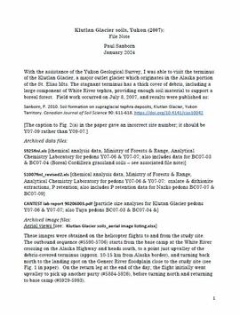
With the assistance of the Yukon Geological Survey, Dr. Paul Sanborn was able to visit the terminus of the Klutlan Glacier, a major outlet glacier which originates in the Alaska portion of the St. Elias Mountains. The stagnant terminus has a thick cover of debris, including a large component of White River tephra, providing enough soil material to support a boreal forest. Field work occurred on July 8, 2007, and results were published as:
Sanborn, P. 2010. Soil formation on supraglacial tephra deposits, Klutlan Glacier, Yukon Territory. Canadian Journal of Soil Science 90: 611-618. https://doi.org/10.4141/cjss10042
2012.13.2.06
·
Subseries
·
1944-2010
Part of J. Kent Sedgwick fonds
Subseries consists of material collected and created by Kent Sedgwick for research relating to community life in Prince George. The files primarily consist of notes and newspaper clippings discussing life in Prince George during the 20th century. Subseries contains material on public services and infrastructure including fire protection, electricity, water towers, policing and jails, and medicine; the history of businesses including Northern Hardware; public events; and recreational activities including hockey, baseball, curling, skiing, tennis, soccer, lacrosse, boxing, horse racing, golfing, and art.
2012.13.2.15
·
Subseries
·
1970-2010
Part of J. Kent Sedgwick fonds
Subseries consists of material collected and created by Kent Sedgwick for research regarding transportation. Includes notes and research on airplanes, specifically Prince George aviation and the Junkers aircraft named "The City of Prince George"; highway transportation; the Grand Trunk Pacific Railway; ferry boat service including the Fraser River Fort George ferry, the Isle Pierre ferry, and the Miworth ferry; the Pacific Great Eastern Railway line; the British Columbia Railway; and the Canadian National Railway. Also includes essays and typed documents on railway history in Prince George.
2012.13.2.05
·
Subseries
·
1964-2010
Part of J. Kent Sedgwick fonds
Subseries consists of material collected and created by Kent Sedgwick for research regarding Indigenous Peoples within British Columbia. These files primarily consist of audio recordings and transcripts of personal oral interviews, documents regarding perceptions of Indigenous peoples, research on historical interactions, Dakelh (Carrier) language, and treaty information including the Nisga'a treaty and Treaty 8. Includes materials on the Carrier Sekani First Nations whose traditional territory includes north central British Columbia and includes the Ts'il Kaz Koh First Nation, Nadleh Whut'en, Saik'uz First Nation, Stellat'en First Nation, Takla Lake First Nation, and Wet'suwet'en First Nations.
2012.13.2.10
·
Subseries
·
1970-2010
Part of J. Kent Sedgwick fonds
Subseries consists of materials collected and created by Kent Sedgwick for research on prominent individuals within Prince George and northern/central British Columbia. These individuals include various photographers, John Warren Meyer, Fannie Kinney, Father Adrien Morice, Henry Spencer Palmer, and Bridget Moran. The files also contain various other obituaries and materials regarding prominent individuals in Prince George.
2023.2.2.6
·
Subseries
·
1983-2010
Part of Dr. Paul Sanborn fonds
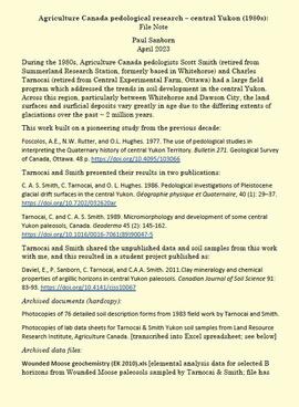
During the 1980s, Agriculture Canada pedologists Scott Smith (retired from Summerland Research Station, formerly based in Whitehorse) and Charles Tarnocai (retired from Central Experimental Farm, Ottawa) had a large field program which addressed the trends in soil development in the central Yukon. Across this region, particularly between Whitehorse and Dawson City, the land surfaces and surficial deposits vary greatly in age due to the differing extents of glaciations over the past ~2 million years.
This work built on a pioneering study from the previous decade:
Foscolos, A.E., N.W. Rutter, and O.L. Hughes. 1977. The use of pedological studies in interpreting the Quaternary history of central Yukon Territory. Bulletin 271. Geological Survey of Canada, Ottawa. 48 p. https://doi.org/10.4095/103066
Tarnocai and Smith presented their results in two publications:
C. A. S. Smith, C. Tarnocai, and O. L. Hughes. 1986. Pedological investigations of Pleistocene glacial drift surfaces in the central Yukon. Géographie physique et Quaternaire, 40 (1): 29–37. https://doi.org/10.7202/032620ar
Tarnocai, C. and C. A. S. Smith. 1989. Micromorphology and development of some central Yukon paleosols, Canada. Geoderma 45 (2): 145-162. https://doi.org/10.1016/0016-7061(89)90047-5
Tarnocai and Smith shared the unpublished data and soil samples from this work with Dr. Paul Sanborn, and this resulted in a student project published as:
Daviel, E., P. Sanborn, C. Tarnocai, and C.A.A. Smith. 2011.Clay mineralogy and chemical properties of argillic horizons in central Yukon paleosols. Canadian Journal of Soil Science 91: 83-93. https://doi.org/10.4141/cjss10067
2023.2.2.12
·
Subseries
·
2007-2009
Part of Dr. Paul Sanborn fonds
A comparative study of grassland soils at 3 sites in northwestern BC and southern Yukon was published as:
Sanborn, P. 2010. Topographically controlled grassland soils in the Boreal Cordillera ecozone, northwestern Canada. Canadian Journal of Soil Science 90: 89-101. https://doi.org/10.4141/CJSS09048
This grew out of a field trip with Ministry of Forests range personnel to the Stikine and Tuya River valleys, near Telegraph Creek BC on August 27-28, 2007. (Two pedons were sampled in 2007, BC07-03 and BC07-04, but those results were not included in the paper.)
In August 2008, Dr. Paul Sanborn returned to the Stikine to sample pedon BC08-06, after field work in Yukon which collected the other two pedons used in the paper, from near Carmacks (Y08-39) and Kluane Lake (Y08-41). (An additional pedon from Kluane, Y08-43, was sampled and analyzed, but it was from a forested site and was not included in the paper.)
2002.14.1.05
·
Subseries
·
1961-2008
Part of Marianne (Marika) Ainley fonds
Subseries contains materials relating to Dr. Ainley's research on women in the fields of science and engineering. Ainley dedicated much of her career to this topic, which resulted in a number of publications. Subseries includes material relating to the submission and editing of Ainley's chapter, "Marriage and Scientific Work in Twentieth-Century Canada: the Berkeleys in Marine Biology and the Hoggs in Astronomy" in "Creative Couples in the Sciences" about the experiences of two scientific couples: Edith and Cyril Berkeley and Frank and Helen Hogg. Materials for this publication include correspondence, edited manuscripts, permissions form templates and a call and instructions for submissions. This subseries also includes research material for a review of Margaret Gillett and Ann Beer's book, "Our Own Agendas: Autobiographical Essays by Women Associated with McGill University," including notes, correspondence and short biographies of women from McGill University. Subseries also contains research on Canadian women in science including photocopied archival materials from various Canadian universities. This subseries also contains materials relating to Ainley's book, "Creating complicated lives: women and science at English-Canadian universities, 1880-1980" and Ainley's chapter, "Soaring to New Heights: Changes in the Life Course of Mabel McIntosh" in "Great Danes." Subseries consists of research relating to women in the Royal Society of Canada and on individual women scientists and engineers. Research materials consist of photocopies of published and archival research materials, correspondence, and applications for grans and ethics reviews. This subseries also contains approximately 80 overhead transparencies from presentations.
2012.13.2.07
·
Subseries
·
1978-2008
Part of J. Kent Sedgwick fonds
Subseries consists of material collected and created by Kent Sedgwick for research relating to agriculture in Prince George and the surrounding areas including Pineview, Mud River, and Blackburn. Includes material regarding the Prince George experimental farm, historical agriculture, dairying, and ranching.
2002.14.1.09
·
Subseries
·
1984-2008, predominant 2001-2006
Part of Marianne (Marika) Ainley fonds
Subseries reflects Dr. Ainley's extensive research on indigenous science and traditional knowledge and how it transferred to European settlers in Canada, Australia, and New Zealand. Much of this research culminated in Dr. Ainley's unfinished monograph project "Re-explorations: new perspectives on gender, environment and the transfer of knowledge in 19th and 20th century Canada and Australia." Material is, predominately, arranged by individual, with files largely consisting of bibliographies, articles and notes about and by the individual on topics related to the environment and interaction with indigenous peoples. Subseries also contains research notes, interviews, and correspondence. As much of Ainley's research focused on women, see subseries on women in science and engineering research (2002.14.1.5) for related materials.
2012.13.1.039
·
Subseries
·
[between 1978 and 2008]
Part of J. Kent Sedgwick fonds
File contains slides depicting subjects related to the Fur Trade.
2002.14.1.10
·
Subseries
·
1982-2007
Part of Marianne (Marika) Ainley fonds
Subseries consists of Dr. Ainley's work collecting oral histories as research materials for various research projects with a predominant focus on the experiences of women scientists. Files usually include interview transcripts, consent forms, any related correspondence, photocopied research materials, and notes.
2002.14.1.12
·
Subseries
·
1980-2006
Part of Marianne (Marika) Ainley fonds
Subseries consists of materials relating to Dr. Ainley's publications including magazine and journal articles, book reviews, book chapters, and encyclopedia entries. Files often contain photocopies of her publications, any related correspondence, reviews of Ainley's publications, drafts and unpublished papers, and publishing and copyright agreements. The topics of these works include women in science and ornithology.
2012.13.1.002
·
Subseries
·
[between 1960 and 2006]
Part of J. Kent Sedgwick fonds
File contains slides depicting the Prince George region.
2002.14.1.06
·
Subseries
·
1993-2006
Part of Marianne (Marika) Ainley fonds
Subseries contains Ainley's research material on Catherine Parr Traill (nee Strickland). The subseries includes research for and manuscripts of: the conference presentation and book chapter, "Science in Canada's 'Backwoods'?: Catharine Parr Traill" (originally titled, "Catharine Parr Traill (1802-1899): A Woman Science Writer in 19th Century Canada"); the conference presentation, "Women and the Popularization of Science: 19th-century Women Science Writers in Canada"; and the conference presentation, "Colonial Lessons: Catherine Parr Traill (1802-99) and Popular Science Education in Upper Canada"; and publication "Circulating Gendered Knowledge: Catharine Parr Traill's Colonial Science Lessons, 1836-1895." Subseries consists of photocopied archival material, research notes, overhead transparencies, correspondence, manuscripts, and articles.
2012.13.1.089
·
Subseries
·
[between 1970 and 2006]
Part of J. Kent Sedgwick fonds
File contains slides depicting places along the east line of the BC Railway.

2023.2.2.3
·
Subseries
·
2004-2006
Part of Dr. Paul Sanborn fonds
As part of a multidisciplinary team led by Grant Zazula (then a Ph.D. student at Simon Fraser University; later a palaeontologist with the Government of Yukon) and Duane Froese (Professor, University of Alberta), Dr. Paul Sanborn examined a set of buried paleosols (fossil soils) preserved in frozen sediments exposed by placer mining in the spring of 2004.
The findings were published in:
Zazula, G.D., D.G. Froese, S.A. Elias, S. Kuzmina, C. La Farge, A.V. Reyes, P.T. Sanborn, C.E. Schweger, C.A.S. Smith, and R.W. Mathewes. 2006. Vegetation buried under Dawson tephra (25,300 14C yr BP) and locally diverse late Pleistocene paleoenvironments of Goldbottom Creek, Yukon, Canada. Palaeogeography, Palaeoclimatology, Palaeoecology 242: 253–286.
https://doi.org/10.1016/j.palaeo.2006.06.005
2012.13.1.006
·
Subseries
·
[between 1970 and 2006]
Part of J. Kent Sedgwick fonds
File contains slides depicting images from around the Northern area of B.C.
2012.13.1.050
·
Subseries
·
[between 1970 and 2006]
Part of J. Kent Sedgwick fonds
File contains slides depicting Highway 97 South.
2023.2.2.4
·
Subseries
·
2004-2005
Part of Dr. Paul Sanborn fonds
The eastern flank of the Mackenzie Mountains has a complex history of multiple glaciations by both the Laurentide and Cordilleran ice sheets, recorded in thick sequences of glacial sediments that were documented at 3 locations (Katherine Creek, Little Bear River, Inlin Brook) by:
Duk-Rodkin, A., R.W. Barendregt, C. Tarnocai, and F.M. Phillips. 1996. Late Tertiary to late Quaternary record in the Mackenzie Mountains, Northwest Territories, Canada: stratigraphy, paleosols, paleomagnetism, and chlorine-36. Canadian Journal of Earth Sciences 33 (6): 875-895. https://doi.org/10.1139/e96-066
Of the 3 sites, the exposure on Inlin Brook, a tributary of the Keele River, was the least well-documented, so in summer 2004 Dr. Paul Sanborn joined a field party of the Geological Survey of Canada (GSC) based at Tulita, NWT, and was given helicopter support to visit Inlin Brook (August 5-8). A brief visit was also made to the Little Bear River site.
On August 9-10, Sanborn joined Alejandra Duk-Rodkin (GSC) and Rene Barendregt (U Lethbridge) in helicopter-assisted field work at sites in the Franklin Mountains and elsewhere east of the Mackenzie River.
2012.13.1.040
·
Subseries
·
[between 1979 and 2004]
Part of J. Kent Sedgwick fonds
File contains slides depicting schools in Prince George, B.C.
2012.13.1.088
·
Subseries
·
[between 1975 and 2004]
Part of J. Kent Sedgwick fonds
File contains slides depicting places along the east line of the BC Railway.
2012.13.1.017
·
Subseries
·
[between 1976 and 2004]
Part of J. Kent Sedgwick fonds
File contains slides depicting CN locations east of Prince George.
2012.13.1.020
·
Subseries
·
[between 1980 and 2004]
Part of J. Kent Sedgwick fonds
File contains slides depicting images of places in or around Red Rock, Hixon, and Woodpecker, B.C.
2012.13.1.096
·
Subseries
·
[between 1987 and 2004]
Part of J. Kent Sedgwick fonds
File contains slides depicting the Kootenay Plains and surrounding areas in Alberta.
2012.13.1.085
·
Subseries
·
[between 1970 and 2004]
Part of J. Kent Sedgwick fonds
File contains slides depicting places in and between McBride and the Yellowhead Pass via the Yellowhead Highway.
2012.13.1.005
·
Subseries
·
[between 1975 and 2003]
Part of J. Kent Sedgwick fonds
File contains slides depicting places in, around, and near Prince George, B.C.
2012.13.1.009
·
Subseries
·
[between 1976 and 2003]
Part of J. Kent Sedgwick fonds
File contains slides that reproduce historical photographs of Indigenous peoples of Central Interior, as well as maps.