2023.2.2.14
·
Subsérie
·
2022-2024
Parte de Dr. Paul Sanborn fonds
762 resultados com objetos digitais
Mostrar resultados com objetos digitais
2023.2.2
·
Série
·
1960-2024
Parte de Dr. Paul Sanborn fonds
Series consists of records created and collected in relation to research projects Dr. Paul Sanborn was engaged in, often with other colleagues, during his employment with the BC Ministry of Forests and/or the University of Northern British Columbia. These archival research records are predominantly unpublished documents, reports, data, and photographs. Some of Sanborn's research projects did not result in a formal scientific publication. In other instances, some of Sanborn's research projects resulted in only a portion of the collected data utilized for a formal publication.
Sanborn compiled details about each research project and its associated records in a summary note. Each of these notes is provided in PDF format along with its research project series. These notes serve as an essential guide for researchers who wish to interpret, utilize, and repurpose Sanborn's data for other future research projects.
2023.2
·
Fundo
·
1960-2024
Fonds consists of the research records of Dr. Paul Sanborn, a University of Northern British Columbia faculty member in the Department of Ecosystem Science and Management.
Sem título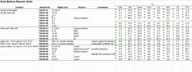
2023.2.2.3.2
·
Item
·
2004, 2023
Parte de Dr. Paul Sanborn fonds
Data set consists of lab data for sites Y04-01 to Y04-04. Original data set created in 2004; an update was provided in March 2023 but horizon designations were not updated to be consistent with the paper.
2023.2.2.5.6
·
Item
·
2004, 2023
Parte de Dr. Paul Sanborn fonds

2023.2.2.7.3
·
Dossiê/Processo
·
2009-2023, predominant 2009-2010
Parte de Dr. Paul Sanborn fonds
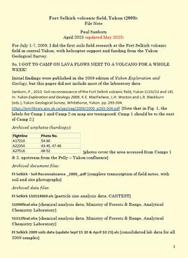
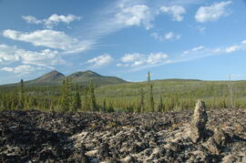
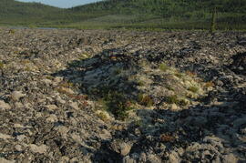
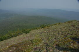
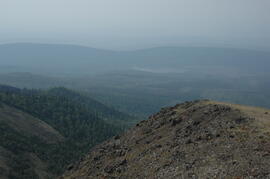
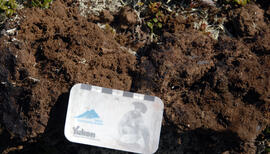
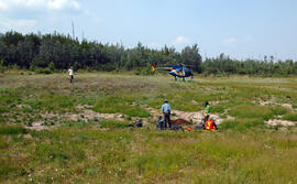
In July 2009, Dr. Paul Sanborn undertook the first soils field research at the Fort Selkirk volcanic field in central Yukon, with helicopter support and funding from the Yukon Geological Survey. This file includes the following data sets gathered from the research:
- Ft Selkirk 110114069.xls [particle size analysis data, CANTEST]
- S1090final.xlsx [chemical analysis data, Ministry of Forests & Range, Analytical Chemistry Laboratory]
- S1112final.xlsx [chemical analysis data, Ministry of Forests & Range, Analytical Chemistry Laboratory]
- Ft Selkirk 2009 soils data (updated Sept 15, 2010 and April 10, 2023).xls [consolidated lab data for all 2009 samples]
2023.2.2.7
·
Subsérie
·
2009-2010, 2023
Parte de Dr. Paul Sanborn fonds
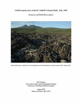
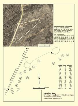
For July 1-7, 2009, Dr. Paul Sanborn did the first soils field research at the Fort Selkirk volcanic field in central Yukon, with helicopter support and funding from the Yukon Geological Survey.
Initial findings were published in the 2009 edition of Yukon Exploration and Geology, but this paper did not include most of the laboratory data:
Sanborn, P., 2010. Soil reconnaissance of the Fort Selkirk volcanic field, Yukon (115I/13 and 14). In: Yukon Exploration and Geology 2009, K.E. MacFarlane, L.H. Weston and L.R. Blackburn (eds.), Yukon Geological Survey, Whitehorse, Yukon. pp. 293-304. https://emrlibrary.gov.yk.ca/ygs/yeg/2009/2009_p293-304.pdf [Note that in Fig. 1, the labels for Camp 1 and Camp 2 on map are transposed; Camp 1 should be to the east of Camp 2.]

2023.2.2.5
·
Subsérie
·
1991-2023, predominant 2004
Parte de Dr. Paul Sanborn fonds
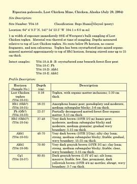
The Lost Chicken Mine, a placer gold mine in eastern Alaska, approximately 120 km west of Dawson City, Yukon, is an important fossil locality for the late Pliocene (approximately 2.5 – 3.0 million years ago). A comprehensive account of the stratigraphy and paleontology of this site was given by:
Matthews, J.V., Jr., J.A. Westgate, L. Ovenden, L.D. Carter, and T. Fouch. 2003. Stratigraphy, fossils, and age of sediments at the upper pit of the Lost Chicken gold mine: new information on the late Pliocene environment of east central Alaska. Quaternary Research 60: 9-18. https://doi.org/10.1016/S0033-5894(03)00087-5
Dr. Paul Sanborn visited the site on July 20, 2004, as part of a group led by Duane Froese (Professor, University of Alberta). The group concentrated on a single exposure (~ 2 m thick) straddling the Lost Chicken tephra, a volcanic ash bed (2.9 ± 0.4 myr) which is a major stratigraphic marker at the site. Sanborn described, photographed, and sampled this exposure, and obtained a basic set of characterization data. Intact samples were collected but thin sections were never produced.
2023.2.2.7.2
·
Dossiê/Processo
·
2009, 2023
Parte de Dr. Paul Sanborn fonds
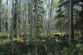
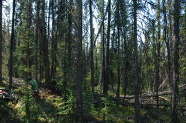
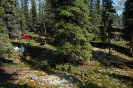
In July 2009, Dr. Paul Sanborn undertook the first soils field research at the Fort Selkirk volcanic field in central Yukon, with helicopter support and funding from the Yukon Geological Survey. This document is a complete transcription of field notes, with
soil and site photographs.
2023.2.1
·
Série
·
1976-2016
Parte de Dr. Paul Sanborn fonds
Series consists of reference material collected by Dr. Paul Sanborn, including field trip guidebooks, resource inventory documents, collected sources for various areas of research, and proceedings and abstracts for conferences and workshops.
2023.2.1.03
·
Dossiê/Processo
·
1987-2016
Parte de Dr. Paul Sanborn fonds
File consists of guidebooks for trips – both in Canada and international – that Paul Sanborn attended. Also includes guidebooks that were given to him by colleagues. Most of these guidebooks relate to soil science, but some deal with Quaternary and bedrock geology.
Includes the following items:
4th International Workshop on Disturbance Dynamics in the Boreal Forest. 2002. A Naturally Disturbing Tour of the Central Interior of British Columbia. August 12, 2002.
18th Biennial Meeting of the American Quaternary Association. 2004. Guidebook for Field Trips. Compiled by Rolfe D. Mandel. June 25, 28-30, 2004.
19th World Congress of Soil Science. 2010. Excursion 2: Brisbane Bayside, 1 August 2010.
19th World Congress of Soil Science. 2010. New Zealand “Volcanoes to Ocean”, Pre-Conference North Island Guidebook, 26th – 30th July 2010.
ASA-CSSA-SSSA International Annual Meeting. 2011. SSSA Soils-Geomorphology Field Tour: Blackland Prairies, Edwards Plateau, and Texas Central Basin. October 20-21, 2011.
Canadian Geophysical Union. 2002. Rocky Mountain highlights and dirt: C.G.U. Field Trip. May 18, 2002. Prepared by: C. Henderson.
Canadian Geophysical Union. 2006. The Burgess Shale and Rocky Mountain Highlights: C.G.U. Field Trip. May 14, 2006. Compiled by C.J. Collom.
Canadian Society of Soil Science. 2014. Soils and Landscapes of the Front Ranges, Foothills, and Great Plains: Field Guide. Compiled by Dan and Lea Pennock. May 2014.
Friends of the Pleistocene – Rocky Mountain Cell. 1995. Late Pleistocene – Holocene Evolution of the Northeastern Yellowstone Landscape: Field conference guidebook. August 25-27, 1995. Compiled by Grant A. Meyer.
Froese, D., P. Matheus, and J. Rasic. 2003. Beringian environments and heritage of the Upper Yukon River: A field workshop from Dawson City, Yukon through Yukon Charley Rivers National Preserve, Alaska. May 30-June 3, 2003. [associated with International Mammoth Conference, Dawson]
Froese, D., R. Woywitka, L. Andriashek, D. Smith, and N. Atkinson. 2013. Field trip guide to the Quaternary geology and geoarchaeology of the Oil Sands region, NE Alberta: August 22-25, 2013. Canadian Quaternary Association.
Geological Association of Canada / Mineralogical Association of Canada. 2016. Veins to Valleys: the Klondike District. Field trip leaders: Jim Mortensen, Jeffrey Bond, Peter Tallman, Grant Zazula. May 28-31, 2016.
Luttmerding, H.A. 1992. Vertisolic soils field tour, British Columbia portion. August 19-23, 1992. BC Ministry of Environment, Lands and Parks.
Morison, S.R., C.A.S. Smith. 1987. XIIth INQUA Congress Field Excursions A20a and A20b: Research in Yukon. National Research Council of Canada, Ottawa.
Northwest Forest Soils Council Field Trip. 2001. Boreal Forest Soils in a Changing Climate. July 9-11, 2001. Fairbanks, Alaska.
Tarnocai, C., C.A.S. Smith, and C.A. Fox. 1993. International Tour of Permafrost Affected Soils: the Yukon and Northwest Territories of Canada. Research Branch, Agriculture Canada, Ottawa. https://sis.agr.gc.ca/cansis/publications/surveys/yt/ytps/ytps_report.pdf
Sanborn, P. 1995. Watershed Restoration in the Olympic National Forest, Hood Canal Ranger District, Washington. September 17-18, 1995. International Conference of Society for Ecological Restoration.
2023.2.2.8
·
Subsérie
·
2003-2014
Parte de Dr. Paul Sanborn fonds
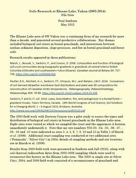
The Kluane Lake area of SW Yukon was a continuing focus of Dr. Paul Sanborn's research for more than a decade, and generated several productive collaborations. Key themes included biological soil crusts in boreal grasslands, and interactions between aeolian sediment deposition, slope processes, and fire in boreal grassland and forest soils.
Research results appeared in these publications:
Marsh, J., Nouvet, S., Sanborn, P., and Coxson, D. 2006. Composition and function of biological soil crust communities along topographic gradients in grasslands of central interior British Columbia (Chilcotin) and southwestern Yukon (Kluane). Canadian Journal of Botany 84: 717-736. https://doi.org/10.1139/b06-026
Pautler, B.G., Reichart, G.-J., Sanborn, P.T., Simpson, M.J., and Weijers, J.W.H. 2014. Comparison of soil derived tetraether membrane lipid distributions and plant-wax δD compositions for reconstruction of Canadian Arctic temperatures. Palaeogeography, Palaeoclimatology, Palaeoecology 404: 78-88. https://doi.org/10.1016/j.palaeo.2014.03.038
Sanborn, P. and A.J.T. Jull. 2010. Loess, bioturbation, fire, and pedogenesis in a boreal forest – grassland mosaic, Yukon Territory, Canada. 19th World Congress of Soil Science, Soil Solutions for a Changing World 1 – 6 August 2010, Brisbane, Australia. http://www.iuss.org/19th%20WCSS/Symposium/pdf/0120.pdf
The 2003 field work with Darwyn Coxson was a pilot study to assess the types and distribution of biological soil crusts in boreal grasslands in the Kluane Lake area. Eight sites were visited at which the team sampled the crust and the uppermost A horizon immediately underneath it. Note that site numbers Y03-03, -04, -05, -06, -07, -09, -10 and -12 were indicated as sites 3, 4, 5, 6, 7, 9, 10 and 12 in Table 1 of Marsh et al. (2006). Additional crust sampling was conducted at two additional sites (“Peninsula”, “Silver City”) in 2004; details of sampling methods and site locations are in Marsh et al. (2006).
Results from 2009 field work were presented in Sanborn and Jull (2010), along with soil charcoal radiocarbon dates from 2003-2008 sampling which were used to reconstruct fire history in the Kluane Lake area. The 2003 (a single site at Silver City), 2004, and 2008 field work consisted of a reconnaissance of grassland and forest sites across a range of aspects and slope positions in order to recover buried soil charcoal.

2023.2.2.8.06
·
Dossiê/Processo
·
2003-2014
Parte de Dr. Paul Sanborn fonds
File consists of the following data sets:
- Kluane crust Min N (2003) S671FINL.xls [mineralizable nitrogen for biological soil crusts & upper mineral soil, 2003 samples]
- Kluane Crust samples (2004) moisture contents.xls [moisture content of air-dry 2004 crust samples from Peninsula & Silver City sites; sampling procedures & locations in Marsh et al. (20060]
- Kluane Soil Crusts (2004) chemical analyses.xls [consolidated file of chemical data for 2004 crust samples from Peninsula & Silver City sites]
- Kluane 2003 soil & crust 15N data.xls [15N natural abundance, total N, organic & inorganic C for 2003 crust & upper mineral soil samples]
- Kluane 2003 soil data.xlsx [consolidated file of chemical data for 2003 crust and mineral horizon soil samples]
- Kluane Crust 2004 total C & N data.xls
- Kluane AMS dates (2003-2008 charcoal samples).xls [radiocarbon dates from the University of Arizona Accelerator Mass Spectrometry Lab]
- Kluane soil transect - texture data.xls [2009 soil particle size analysis data, with potential lithological breaks highlighted]
- Kluane surveys 2009.xls [topographic surveys for 3 soil transects cutting across eskers along Cultus Bay Rd., SE shore of Kluane L.]
- S1061_1069_Final_Rev1.xls [lab data report from Ministry of Forests Analytical Chemistry Laboratory for 2009 transect samples: total C, inorganic C, & total N]
- 100812003 (annotated) -corrected.xls [2009 transect samples: particle size analysis data report from CANTEST]
- Kluane soil transect - master data file.xls
2023.2.2.1
·
Subsérie
·
1988-2011
Parte de Dr. Paul Sanborn fonds
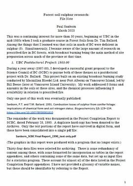
Forest soil sulphur research was a continuing interest for Dr. Paul Sanborn for more than 30 years, beginning at UBC in the mid-1980s when he took a graduate course in Forest Soils from Dr. Tim Ballard. Among the things that he learned was that soils in much of BC were deficient in sulphur (S). Simultaneously, he became aware of the large amount of research on prescribed fire in BC forests, with broadcast burning being the main method of site preparation across much of the province at that time.
Sanborn undertook various projects in this area of research:
- UBC Postdoctoral Project on effects of prescribed fire on sulphur in forest soils (1988-90)
- Cluculz retrospective study (E.P. 886.10) with the BC Ministry of Forests and UNBC
- Sulphur stable isotope tracer study (E.P. 886.15) with the BC Ministry of Forests and UNBC
2023.2.2.1.3
·
Sub-subseries
·
1998-2011
Parte de Dr. Paul Sanborn fonds
The Sulphur stable isotope tracer study (E.P. 886.15) field experiment was installed in young lodgepole pine stands at two sites in the Prince George Forest Region in 2001, with fertilizer treatments applied in late 2002. These sites are designated as Kenneth Creek (east of Prince George) and Holy Cross (south of Fraser Lake). (The Kenneth Creek installation was established near plots of the older E.P. 886.13 in the same stand.) Full experimental details, including pretreatment soil and foliar date, were given in:
Sanborn, P., R.P. Brockley, B. Mayer, M. Yun, J. Prietzel. 2005. Sulphur fertilization of lodgepole pine: a stable isotope tracer study (E.P. 886.15): Establishment report. Tech. Rep. 020. B.C. Min. For., Res. Br., Victoria, BC. http://www.for.gov.bc.ca/hfd/pubs/Docs/Tr/Tr020.htm
The Kenneth Creek site was attacked by mountain pine beetle in 2006, resulting in at least 80% tree mortality. In 2013, the stand was levelled in order to enable replanting, and due to poor communications within the Ministry of Forests, the opportunity to salvage this installation was lost. The Holy Cross site was hit by a wildfire in 2010, and most of the research plots were destroyed.
Preliminary results from foliar analysis, sufficient to demonstrate that our stable isotope tracer approach could detect fertilizer uptake, were published in:
Sanborn, P.T., R.P. Brockley, and B. Mayer. 2011. Stable isotope tracing of fertilizer uptake by lodgepole pine: foliar responses. Can. J. For. Res. 41: 493-500. https://cdnsciencepub.com/doi/full/10.1139/X10-222

2023.2.2.1.3.7
·
Item
·
[2010?]
Parte de Dr. Paul Sanborn fonds
Document is a research installation layout map for the Kenneth Creek site of the Sulphur stable isotope tracer study (E.P. 886.15).
2023.2.2.1.3.8
·
Dossiê/Processo
·
2003-2010
Parte de Dr. Paul Sanborn fonds
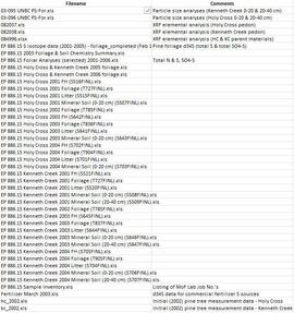
Data sets for the Sulphur stable isotope tracer study (E.P. 886.15) include:
- 03-095 UNBC PS-For.xls Particle size analyses (Kenneth Creek 0-20 & 20-40 cm)
- 03-096 UNBC PS-For.xls Particle size analyses (Holy Cross 0-20 & 20-40 cm)
- 082037.xls XRF elemental analysis (Holy Cross pedon)
- 082038.xls XRF elemental analysis (Kenneth Creek pedon)
- 084996.xlsx XRF elemental analysis (HC & KC parent materials)
- EP 886 15 S isotope data (2001-2005) - foliage_completed (Feb 18).xls Pine foliage d34S (total S & total SO4-S)
- EP 886.15 2003 Foliage & Soil Chemistry Summary.xls
- EP 886.15 Foliar Analyses (selected) 2001-2006.xls Total N & S, SO4-S
- EP 886.15 Holy Cross & Kenneth Creek 2005 foliage.xls
- EP 886.15 Holy Cross & Kenneth Creek 2006 foliage.xls
- EP 886.15 Holy Cross 2001 FH (S516FINL).xls
- EP 886.15 Holy Cross 2001 Foliage (T727FINL).xls
- EP 886.15 Holy Cross 2001 Litter (S515FINL).xls
- EP 886.15 Holy Cross 2001 Mineral Soil (0-20 cm) (S507FINL).xls
- EP 886.15 Holy Cross 2002 Foliage (T785FINL).xls
- EP 886.15 Holy Cross 2003 FH (S642FINL).xls
- EP 886.15 Holy Cross 2003 Foliage (T836FINL).xls
- EP 886.15 Holy Cross 2003 Litter (S641FINL).xls
- EP 886.15 Holy Cross 2003 Mineral Soil (0-20 cm) (S643FINL).xls
- EP 886.15 Holy Cross 2004 FH (S702FINL).xls
- EP 886.15 Holy Cross 2004 Foliage (T904FINL).xls
- EP 886.15 Holy Cross 2004 Litter (S701FINL).xls
- EP 886.15 Holy Cross 2004 Mineral Soil (0-20 cm) (S703FINL).xls
- EP 886.15 Kenneth Creek 2001 FH (S521FINL).xls
- EP 886.15 Kenneth Creek 2001 Foliage (T727FINL).xls
- EP 886.15 Kenneth Creek 2001 Litter (S520FINL).xls
- EP 886.15 Kenneth Creek 2001 Mineral Soil (0-20 cm) (S508FINL).xls
- EP 886.15 Kenneth Creek 2001 Mineral Soil (20-40 cm) (S509FINL).xls
- EP 886.15 Kenneth Creek 2002 Foliage (T785FINL).xls
- EP 886.15 Kenneth Creek 2003 FH (S645FINL).xls
- EP 886.15 Kenneth Creek 2003 Foliage (T837FINL).xls
- EP 886.15 Kenneth Creek 2003 Litter (S644FINL).xls
- EP 886.15 Kenneth Creek 2003 Mineral Soil (0-20 cm) (S646FINL).xls
- EP 886.15 Kenneth Creek 2003 Mineral Soil (20-40 cm) (S647FINL).xls
- EP 886.15 Kenneth Creek 2004 FH (S705FINL).xls
- EP 886.15 Kenneth Creek 2004 Foliage (T905FINL).xls
- EP 886.15 Kenneth Creek 2004 Litter (S704FINL).xls
- EP 886.15 Kenneth Creek 2004 Mineral Soil (0-20 cm) (S706FINL).xls
- EP 886.15 Kenneth Creek 2004 Mineral Soil (20-40 cm) (S707FINL).xls
- EP 886.15 Sample Inventory.xls Listing of MoF Lab Job No.'s
- Fertilizer March 2003.xls d34S data for commercial fertilizer S sources
- hc_2002.xls Initial (2002) pine tree measurement data - Holy Cross
- kc_2002.xls Initial (2002) pine tree measurement data - Kenneth Creek
2023.2.2.13
·
Subsérie
·
2007-2010
Parte de Dr. Paul Sanborn fonds
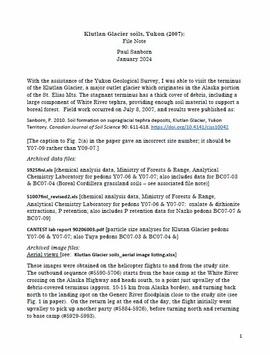
With the assistance of the Yukon Geological Survey, Dr. Paul Sanborn was able to visit the terminus of the Klutlan Glacier, a major outlet glacier which originates in the Alaska portion of the St. Elias Mountains. The stagnant terminus has a thick cover of debris, including a large component of White River tephra, providing enough soil material to support a boreal forest. Field work occurred on July 8, 2007, and results were published as:
Sanborn, P. 2010. Soil formation on supraglacial tephra deposits, Klutlan Glacier, Yukon Territory. Canadian Journal of Soil Science 90: 611-618. https://doi.org/10.4141/cjss10042
2023.2.2.1.3.6
·
Item
·
[2010?]
Parte de Dr. Paul Sanborn fonds
Document is a research installation layout map for the Holy Cross Creek site of the Sulphur stable isotope tracer study (E.P. 886.15).
2023.2.2.6
·
Subsérie
·
1983-2010
Parte de Dr. Paul Sanborn fonds
During the 1980s, Agriculture Canada pedologists Scott Smith (retired from Summerland Research Station, formerly based in Whitehorse) and Charles Tarnocai (retired from Central Experimental Farm, Ottawa) had a large field program which addressed the trends in soil development in the central Yukon. Across this region, particularly between Whitehorse and Dawson City, the land surfaces and surficial deposits vary greatly in age due to the differing extents of glaciations over the past ~2 million years.
This work built on a pioneering study from the previous decade:
Foscolos, A.E., N.W. Rutter, and O.L. Hughes. 1977. The use of pedological studies in interpreting the Quaternary history of central Yukon Territory. Bulletin 271. Geological Survey of Canada, Ottawa. 48 p. https://doi.org/10.4095/103066
Tarnocai and Smith presented their results in two publications:
C. A. S. Smith, C. Tarnocai, and O. L. Hughes. 1986. Pedological investigations of Pleistocene glacial drift surfaces in the central Yukon. Géographie physique et Quaternaire, 40 (1): 29–37. https://doi.org/10.7202/032620ar
Tarnocai, C. and C. A. S. Smith. 1989. Micromorphology and development of some central Yukon paleosols, Canada. Geoderma 45 (2): 145-162. https://doi.org/10.1016/0016-7061(89)90047-5
Tarnocai and Smith shared the unpublished data and soil samples from this work with Dr. Paul Sanborn, and this resulted in a student project published as:
Daviel, E., P. Sanborn, C. Tarnocai, and C.A.A. Smith. 2011.Clay mineralogy and chemical properties of argillic horizons in central Yukon paleosols. Canadian Journal of Soil Science 91: 83-93. https://doi.org/10.4141/cjss10067

2023.2.2.6.4
·
Dossiê/Processo
·
2010
Parte de Dr. Paul Sanborn fonds
This data set consists of elemental analysis data for selected B horizons from Wounded Moose paleosols sampled by Tarnocai and Smith. The file includes the original ALS lab report, additional panes showing comparison of replicates, and calculation of a weathering index.

2023.2.2.7.4.006
·
Item
·
2009
Parte de Dr. Paul Sanborn fonds

2023.2.2.7.4.008
·
Item
·
2009
Parte de Dr. Paul Sanborn fonds

2023.2.2.7.4.013
·
Item
·
2009
Parte de Dr. Paul Sanborn fonds

2023.2.2.7.4.021
·
Item
·
2009
Parte de Dr. Paul Sanborn fonds

2023.2.2.7.4.022
·
Item
·
2009
Parte de Dr. Paul Sanborn fonds

2023.2.2.7.4.026
·
Item
·
2009
Parte de Dr. Paul Sanborn fonds

2023.2.2.7.4.029
·
Item
·
2009
Parte de Dr. Paul Sanborn fonds

2023.2.2.7.4.030
·
Item
·
2009
Parte de Dr. Paul Sanborn fonds

2023.2.2.7.4.031
·
Item
·
2009
Parte de Dr. Paul Sanborn fonds

2023.2.2.7.4.033
·
Item
·
2009
Parte de Dr. Paul Sanborn fonds

2023.2.2.7.4.050
·
Item
·
2009
Parte de Dr. Paul Sanborn fonds

2023.2.2.7.4.052
·
Item
·
2009
Parte de Dr. Paul Sanborn fonds
2023.2.2.7.4.053
·
Item
·
2009
Parte de Dr. Paul Sanborn fonds
2023.2.2.7.4.057
·
Item
·
2009
Parte de Dr. Paul Sanborn fonds
2023.2.2.7.4.058
·
Item
·
2009
Parte de Dr. Paul Sanborn fonds
2023.2.2.7.4.061
·
Item
·
2009
Parte de Dr. Paul Sanborn fonds
2023.2.2.7.4.075
·
Item
·
2009
Parte de Dr. Paul Sanborn fonds
2023.2.2.7.4.081
·
Item
·
2009
Parte de Dr. Paul Sanborn fonds
2023.2.2.7.4.082
·
Item
·
2009
Parte de Dr. Paul Sanborn fonds

2023.2.2.7.4.086
·
Item
·
2009
Parte de Dr. Paul Sanborn fonds

2023.2.2.7.4.087
·
Item
·
2009
Parte de Dr. Paul Sanborn fonds
2023.2.2.7.4.093
·
Item
·
2009
Parte de Dr. Paul Sanborn fonds
2023.2.2.7.4.105
·
Item
·
2009
Parte de Dr. Paul Sanborn fonds
2023.2.2.7.4.107
·
Item
·
2009
Parte de Dr. Paul Sanborn fonds
2023.2.2.7.4.109
·
Item
·
2009
Parte de Dr. Paul Sanborn fonds

2023.2.2.7.4.112
·
Item
·
2009
Parte de Dr. Paul Sanborn fonds
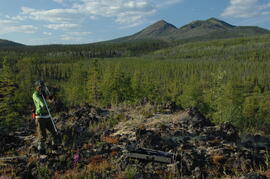
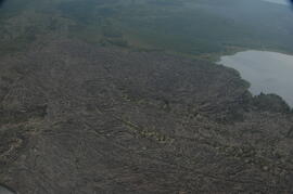
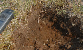
This image appears as Figure 8 in the publication:
Sanborn, P., 2010. Soil reconnaissance of the Fort Selkirk volcanic field, Yukon (115I/13 and 14).
In: Yukon Exploration and Geology 2009, K.E. MacFarlane, L.H. Weston and L.R. Blackburn
(eds.), Yukon Geological Survey, Whitehorse, Yukon. pp. 293-304. https://emrlibrary.gov.yk.ca/ygs/yeg/2009/2009_p293-304.pdf
2023.2.2.7.4.115
·
Item
·
2009
Parte de Dr. Paul Sanborn fonds

2023.2.2.7.4.118
·
Item
·
2009
Parte de Dr. Paul Sanborn fonds
2023.2.2.7.4.121
·
Item
·
2009
Parte de Dr. Paul Sanborn fonds