Item is a newsletter entitled "Old Growth: What is at stake?".
Item is a photocopied draft of the Northern Wetlands Research Project Final Report by P. Lynch-Stewart, B. Heli & D. Ouimet for Lands Directorate, Environment Canada.
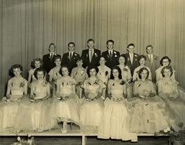
Photograph depicts the North Peace High School Class of 1957 of Fort St. John. G. Gary Runka is the third from the left, back row. Other individuals are unidentified.
Item is a copy of the "North American Water and Power Alliance (NAWAPA)" presentation to Cornell University Water Resources Center, Ithaca, New York by Roland P. Kelly, Edward R. Trapnell, and Ralph M. Parsons Company.
Item is an original copy of "Non-Farmland with Long Term Urban Potential in the South Okanagan" by the BC Agricultural Land Commission.
Item is an original copy of "Non-Farmland with Long Term Urban Potential in the Lower Mainland" by the BC Agricultural Land Commission.
Item is an original booklet by BC Cattlemen's Association entitled "Munching the Myths: a Factual Account of the Beef Cattle Industry in British Columbia".
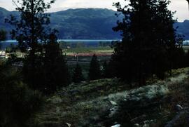
Slide depicts orchards surrounding Mount Boucherie. The Okanagan Lake and mountains can be seen in the background. Original slide index description: "Orchards & sunflowers from Mt. Boucherie."
Item is an original copy of "Moran Dam Environmental Analysis" by the Cariboo Land Capability Analysis Committee and Intersector Special Study Committee of the British Columbia Canada Land Inventory. The committee members were A. Bedwany, D. Benn, D. Blower, R. Marshall, and G. Runka. Includes 24 original colour photographic prints pasted into the report.
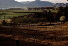
Slide depicts Mission Flats from South East Kelowna. Photograph taken from an empty field and depicts a developed field and a wooden house. Mountains and the Okanagan Lake can be seen in the background. Original slide index description: "Mission Flats from SE Kel."
Item is a photocopied version of the "Ministry of Transportation and Highways, Province of British Columbia, Cattle Drives on Highways - Draft Policy" by Lorne M. Holowachuk, BC Highway Safety Branch.
Photocopied map depicts mineral and coal mining properties in north western British Columbia.
Item is an original copy of "Methodology - Land Capability for Agriculture - B.C. Land Inventory (CLI)" by G.G. Runka at the Soil Survey Division, BC Department of Agriculture.
Item is a draft of J.W. Schwab's paper for the 10th BC Soil Science Workshop (February 20-21, 1986) entitled "Mass Wasting Impacts to Forest Land: Forest Management Implication, Queen Charlotte Islands".
Item is an original copy of the "Manitoba Land Use Conference Proceedings" on March 11-12, 1981 in Winnipeg. Gary Runka presented on his paper, "Expanding Needs from a Finite Resource: The Necessity for Sound Land Use Planning".
Item is a copy of "Management Strategy for the Driftwood-Reiseter Planning Area".
Item is an original BC Department of Agriculture publication entitled "Management and Improvement of Meadows on Organic Soils of Interior British Columbia".
Item is an original copy of "Making a Difference: The Canada Land Inventory" Fact Sheet 88-5 by the Canadian Wildlife Service, Environment Canada.
Area covered: Howe Sound to Maple Ridge/Langley / Coquitlam Lake to international boundary.
Shows: lost streams & shores; existing streams & shores; existing freshwater bodies of water; roads; municipalities.
Verso: Stewarding our local streams; Stream stories; text; illustrations.
Contemporary stream information from TRIM program.
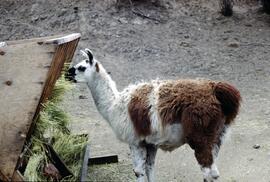
Slide depicts a close up of a llama eating hay. The photograph was taken in Kaleden, BC. Original slide index description: "Llama, Kaleden."
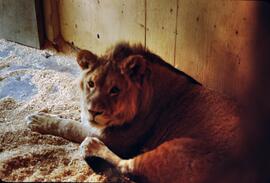
Slide depicts a close up of a lion lying on wood shavings in an enclosed area. The photograph was taken in Kaleden, BC. Original slide index description: "lion, Kaleden."
Item is a copy of "Lil'wat Land Use Plan: Phase 1".
Item is an original copy of the 1998 reprint of "Landscaped Buffer Specifications" by the Agricultural Land Commission.
Item is a report entitled "Landscaped Buffer Investigation" a summary prepared by BC Ministry of Agriculture, Fisheries and Food for the Land Reserve Commission.
Item is an original copy of "Lands of the East Kootenay: Their characteristics and capability for agriculture and forestry - Report to the B.C. Soil Capability for Agriculture and Forestry Committee", a co-operative interim report comprising sections and maps, compiled by G. G. Runka, Soils Division, BC Department of Agriculture. Other authors include J.R. Jungen, T. Lewis, J.R. Marshall, M.J. Romaine, J. van Barneveld, and U. Wittneben.
Item is an original report prepared by Salasan Associates Inc. & Erlandson and Associates for the Forest Resources Commission entitled "Land Use Planning System for British Columbia".
Item is an original unbound copy of "Land Productivity in British Columbia" by the Select Standing Committee on Agriculture of the BC Legislative Assembly.
This presentation transcript accompanies the 1973 BC Land Commission photographic slide and audio tape set entitled "Land Commission Act and the Agricultural Reserve Plan" that was used in original public hearings throughout the province. The presentation was given by Bill Lane, BC Land Commission Chair, and Gary Runka, BC Land Commission General Manager.
Item is an original article reprint by G.S. Swinnerton from BC Ministry of Agriculture, Fisheries and Food Technical Bulletin No. 30 on Land Capability Classification entitled "Land Classification and Environmental Planning".
Item is a typescript by J.C. Hertherington and R.C. Kowall entitled "Land Capability for Forestry: A Report to the British Columbia Forest Service by the Canada Land Inventory Staff - East Kootenay (Region 13)".
Item is an original BC Ministry of Agriculture publication entitled "Knapweed: Its Cause and Effect in British Columbia".
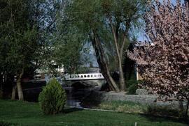
Slide depicts the park entranceway to Kelowna on the East side of the Okanagan Lake Bridge. Original slide index description: "Park entrance to Kelowna."
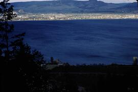
Slide depicts Kelowna and Casa Loma photographed during the day from across the Okanagan Lake in the Lakeview Heights area. Original slide index description: "Kel & Casa Loma from Lakeview Hts."
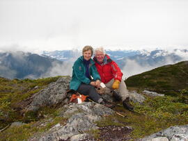
Photograph depicts Joan Sawicki and Gary Runka on an outcropping overlooking South Bentinck Arm, Great Bear Rainforest on the BC Central Coast.
Item is an original "Jasper National Park Management Plan Review Comment Form" for Parks Canada.
Item is an original copy of the Phase 1 research report "Inventory of Agricultural Land Reserves in British Columbia" by the Select Standing Committee on Agriculture of the BC Legislative Assembly.
Item is an original copy of "Intermountain Wetland Conservation Program Prospectus: A Partnership for Environmental Stewardship and Land Use Sustainability" by Ducks Unlimited Canada.
Item is an original copy of "Interior Program Feasibility Study: A report submitted to Dr. W. D. Kitts, Dean of Faculty of Agricultural Sciences by the Dean's Interior Program Committee". The report was prepared in consultation with G. G. Runka Land Sense Ltd.
Item is an original booklet entitled "Indian Land Claims in British Columbia" by First Nations Congress.
Item is a pamphlet entitled "Index of Soil Surveys in British Columbia 1993".
Item is a photocopied the "Hotnarko L.R.U.P." document produced by the Chilcotin Forest District in 1989.
DVD disc contains two documents:
- "KCB Design Update for L-L Dam Crest Elevation 1279 m.pdf"
- "Piteau 2605-R02-FINAL_Revised_Sep2010.pdf" which is a Piteau Associates report for the Highland Valley Copper mine at Logan Lake regarding "Open Pit Geotechnical Assessments and Slope Design Criteria for the Lornex Pit L16 Expansion"
Item is an original supplement to Valley Echo entitled "Height-of-the-Rockies Wilderness Area: A vision realized" created by the British Columbia Forest Service.
Item is a computer printout of the "Haida Gwaii Queen Charlotte Islands Heritage Tourism Strategy" by the Heritage Tourism Strategy Working Group.
