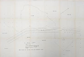
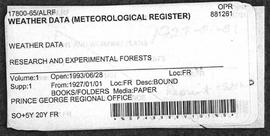
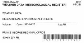
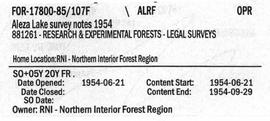
File contains photocopies of survey notes from 1954.
Series contains survey notes.
Map reflects reserve boundary, roads, trails, 20 feet contour intervals, air photo centre, declination, swamps, and mile post at the Aleza Lake Experiment Forest.
Maps reflect reserve boundary, roads, trails, 20 feet contour intervals, air photo centre, declination, swamps, and mile post.
Map commissioned from Ministry of Forests Prince George Region from Madrone Consultants shows Aleza Lake Research Forest site series classification. Shows ecosystem types that encompass the SBSwk1 Subzone of the Aleza Lake Research Forest.
Map commissioned from Ministry of Forests Prince George Region from Madrone Consultants shows Aleza Lake Research Forest Terrain Resource Inventory Mapping (TRIM). Depicts roads, area boundaries, swamps, streams, marshes, contour lines and index lines.
Map commissioned from Ministry of Forests Prince George Region from Madrone Consultants shows Aleza Lake Research Forest terrain themes. Map is 6 of 6. Map shows the following types of terrain units: typic, slope, percipitous, gullied, hummocky, rocky, alluvial, and organic. Ecosystem classification and mapping by Oikos Ecological Services Ltd.
Map commissioned from Ministry of Forests Prince George Region from Madrone Consultants shows Aleza Lake Research Forest ecosystems. Map is 5 of 6. Map shows many sub-types of the following ecosystem types: upland, lowland wet forest, wetlands, and the Bowron floodplain benches. Ecosystem classification and mapping by Oikos Ecological Services Ltd.
Map commissioned from Ministry of Forests Prince George Region from Madrone Consultants shows an Aleza Lake Research Forest TRIM Base Map. Map is 4 of 6. Map shows the following: roads, old roads, buildings, rail line, transmission line, definite streams, intermittent streams, indefinite streams, marshes, swamps, lakes, wooded area boundaries, intermediate contour lines (20m intervals), and index contour lines (100m intervals).
Map commissioned from Ministry of Forests Prince George Region from Madrone Consultants shows Aleza Lake Research Forest Access and Access Management. Map is 3 of 6. Map shows the following road types: all weather 1-lane gravel road, dry weather road, and proposed road access. Also shows areas for parking/turnaround, toilets, and information signs.
Map commissioned from Ministry of Forests Prince George Region from Madrone Consultants shows Aleza Lake Research Forest Research Trials and Permanent Plots. Map is 2 of 6. Map shows permanent plot locations, historical timber sales areas, demonstration areas, and research plots.
Map commissioned from Ministry of Forests Prince George Region from Madrone Consultants shows Aleza Lake Research Forest Management Compartments and Administrative Boundaries. Map is 1 of 6. Map shows the Aleza Lake Ecological Reserve, Natural Forest Reserve, the Special Management Area, and Riparian Management Research Area.
Large scale map shows Aleza Lake Research Forest permanent sample plot 112. Includes information about live and dead trees and their species (spruce, balsam, birch, douglas fir). Also includes remeasurement history. Plot 112 was established in 1926 and is an unlogged, old growth, uneven aged, spruce-balsam stand.
Large scale map shows Aleza Lake Research Forest permanent sample plot 103. Includes information about live and dead trees and their species (spruce, balsam, birch, douglas fir). Also includes remeasurement history. Plot 103 was established in 1926 and is an unlogged, old growth, uneven aged, spruce-balsam stand.
Map reflects forest type boundary line, bogs and swampy non-forested areas, creeks, lakes, rivers, tree species labels of spruce, balsam, and birch, stand descriptions, historical timber sale boundaries, stand history symbol, gravelled secondary roads, unimproved old roads, management compartment boundary, research forest boundary, ecological reserve boundary, and old growth emphasis areas.
Map reflects highways, main, branch and property roads, trails, public sustained yield unit boundaries, cutting permit boundary, contours, height of land, edge of lake, merchantable and immature timber, non-commercial cover, and swamps.
Map reflects soil and landforms of Giscome area.
Map reflects boundaries for the Aleza Lake Experiment Station, permanent sample plots, timber sales locations, and the Ecological Reserve.
Map reflects lot and STL lines, timber sale boundaries, Highway 16, roads, beetle infested areas, and plots X91971 to X91980, and X89946.
Technical drawing reflects depth of sand established as more and less than 6 feet.
Diagram reflects outline for the proposed Ranger Station at the Aleza Lake Experimental Forest.
Map reflects reserve boundary, roads, trails, 20 feet contour intervals, air photo centre, declination, swamps, and mile post at the Aleza Lake Forest Reserve.
File contains datelines, small maps consisting of ecological site types, handwritten notes, overheads, terrain resource management information digital map data, and trail system maps.
Series consists of cartographic materials including maps and blueprints of the Aleza Lake Research Forest. The maps reflect permanent sample plots and other study areas. The blueprints outline details for the development of a Ranger Station.
File contains handwritten messages, photocopied invitations to a field tour, and related correspondence.
File contains road reconstruction project reports, photocopies of invoices and work orders, records of daily costs, photocopies of hired equipment daily time reports, related correspondence, and maps.
Item is the BC Forest Service's "A Guide to Stand Treatment".
Item is "The North Ridge Eco-Trail Guide: Aleza Lake Research Forest".
Item is "Cluculz Lake Silviculture Demonstration Area Trail Guide" by the BC Ministry of Forests.
Item is "The Aleza Lake Experiment Station (1920's and 1930's)" by Ralph Schmidt and the British Columbia Forest Service.
File contains a 1921 original copy of "The Talking Trees and Canadian Forest Trees" by James Lawler and the Department of the Interior Forestry Branch.
File contains a 1931 original copy of "The Aleza Lake Forest Experiment Station: A Brief Statement of its Purpose and Development". Includes photographs.
File contains trail guide brochures, a 1931 original copy of the Aleza Lake Experiment Station statement of its purpose and development, and other forest related brochures and books.
File contains a trail guide, a report on potential trail building, and related maps.
Series contains project reports, invoices, work orders, daily costs, maps, correspondence, forest related brochures and books, and trail guides.
File contains climate data of soil and air temperatures, correspondence relating to climate studies, original and photocopied receipts for items related to the study, and computer generated graphs.
Floppy contains flag files (AL52-65F.dat, AL66-80F.dat) and Fortran programs (AES.for, AESEXT.for, AESFLG.for).
Floppy contains the following files: AL52-55.wk1, AL56-60.wk1, AL61-65.wk1, AL66-70.wk1, AL71-75.wk1, AL76-80.wk1, ALX52-80.wk1
Floppy contains the following files: AL52-55.dat, AL56-60.dat, AL61-65.dat, AL66-70.dat, AL71-75.dat, AL76-80.dat
File contains Aleza Lake Experiment Station Climate Station data from 1952 to 1980 and three accompanying floppies with weather data and Fortran programs.
File contains Aleza Lake Research Forest weather records from 1927 to 1934 and 1928 to 1933.
File contains original handwritten metereological registers.
File contains maps and information related to climate station installation, including reports and tables.
Series contains correspondence, meteorological registers, graphs, receipts, computer disks, maps, weather records, and other climate data.