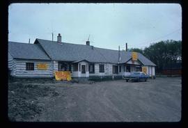
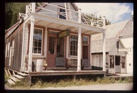
Image depicts an abandoned building on the corner of a street in McBride, B.C. The faded letters on the side read: "McBride Trading Co. Mens Wear, Drugs, Equipment."
Image depicts a row of buildings in Upper Fraser, B.C. with the store (titled "Paradise") with a Pepsi sign. Map coordinates 54°07'09.1"N 121°56'47.0"W
Image depicts a street in Giscome B.C. The Giscome Store is located on the left side of the image with the church in the background. Map coordinates 54°04'18.5"N 122°21'57.7"W
Image depicts a snowy street in Willow River, B.C. There are several buildings, one is an Esso station and another is labelled as "Red & White Food Store."
Image depicts a street in Hudson's Hope, B.C.
Image depicts a street of businesses in Dawson Creek, B.C.
Image depicts a street of businesses and Mile "0" of the Alaskan Highway in Dawson Creek, B.C.
Image depicts a Chevron station as well as two motels in Chetwynd, B.C.
Image depicts the Station Museum and the "Alberta Pool Elevators Ltd." building in Dawson Creek, B.C.
The item is a poster showcasing redevelopment plans for Prince George's downtown.
File consists of clippings, notes, and reproductions relating to the Bank of Montreal in Prince George. Includes photographs depicting the Caine building and the Bank of Montreal in Prince George (2007-2009).
Image depicts 3rd Ave at Victoria St. Map coordinates 53°55'03.9"N 122°44'54.8"W
Image depicts Central Street West, parallel to Highway 97 in Prince George, B.C. looking north. Shown: Prince George Motors and other car dealerships, Burger King, Grama's Inn, and the Spruceland Shopping Mall sign. Map coordinates 53°54'42.1"N 122°46'53.1"W
Image depicts the Wake Up Jake Saloon in Barkerville, as well as several other buildings.
Image depicts the interior of the historic Hudson's Bay Company Trading Post in Fort St. James, B.C.
Image depicts the interior of the historic Hudson's Bay Company Trading Post, with several unknown individuals present, in Fort St. James, B.C.
Image depicts what appears to be a motel somewhere near Bralorne, B.C.
Image depicts the "Riske Creek General Store" in Riske Creek, B.C.
Image depicts the Bank of Montreal in Prince George, B.C.
Image depicts the Javva Mugga Mocha Cafe in Prince George, B.C.
Image depicts a street of businesses, possibly 3rd Avenue, in Prince George, B.C.
Image depicts numerous businesses, such as the Bay, Overwaitea, and Dairy Queen, somewhere in Kitimat, B.C.
Image depicts a hotel in Likely, B.C.
Image depicts numerous vehicles parked outside a building with a sign which reads "Mackenzie Centre;" it is possibly the mall in Mackenzie, B.C.
Image depicts the gas station at Manson Creek, B.C.
Image depicts the interior of a mall in Prince Rupert, B.C. It is possibly the Pride O' the North shopping mall.
Image depicts the Pride O' the North shopping mall in Prince Rupert, B.C.
Image depicts the main street of Stewart, B.C.
Image depicts several buildings along the main street in Stewart, B.C.
Image depicts the abandoned and crumbling Forman's General Store somewhere in or near either Barkerville or Wells, B.C.
Image depicts the original bank building in Wells, B.C.
Image depicts a street in Burns Lake, B.C.
Image depicts downtown Prince George looking northwest across Dominion Street. Map coordinates 53°54'48.7"N 122°44'45.6"W
Image depicts 4th Ave at Brunswick St. and the following businesses: Hart Drugs, The Yarn Barn, and Saveco. Map coordinates 53°54'59.9"N 122°44'52.9"W
Image depicts 4th Ave at Quebec St, showing the following businesses: The Yarn Barn, Golden Chalice Jewellers, Dandy Lines, Ultrasport, and Saveco. Map coordinates 53°54'58.6"N 122°44'47.5"W
Image depicts 3rd Ave in Prince George, B.C. Map coordinates 53°55'01.9"N 122°44'48.7"W
Image depicts downtown Prince George, B.C.
Image depicts the Ramada Hotel in Prince George, B.C.
Image depicts an aerial view of Pine Centre Mall and Masich Place Stadium in Prince George, B.C.
Image depicts the Prince George Multiplex.
Image depicts the House Hotel in Barkerville, B.C.
Image depicts a building somewhere in Wells, B.C. There is a sign in one window which reads "Lon Oddfrey Insurance Realty LTD."
Image depicts a crowd of people outside the Wells Hotel in Wells, B.C.
Image depicts the interior of an old convenience store; numerous unknown individuals are present. It is located at the 153 Mile House.
Image depicts a street in Telkwa, B.C.
Image depicts a grocery store at Island Cache.
Image depicts the Jack O' Clubs Hotel in Wells, B.C. It burned down on February 14th, 1994
Image depicts the Garrett Store in Atlin, B.C. A plaque on it reads: "John Garrett, a prominent English cricket player, came to Atlin in 1910 to mine gold. In 1917 he opened this grocery and dry goods store where he also sold his wife's fresh baked bread and sweets."