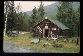
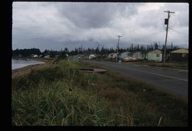
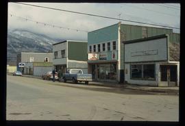
File contains slides depicting places in and around Manson Creek.
Image depicts a man and his family filling up their truck with gas at Manson Creek, B.C.
Image depicts the gas station at Manson Creek, B.C.
Image depicts a creek with a half collapsed shack in the background somewhere in Manson Creek. The slide is labelled "Manson workings."
Image depicts the Omineca Museum in Manson Creek, B.C.
Image depicts the road to Manson Creek, B.C.
Image depicts a man holding up a board which appears to have maps of the Cottonwood Park on it.
The item is a photograph slide depicting a map of Mackenzie Island. The map depicts Central Fort George, South Fort George, Mackenzie Island and the Nechako/Fraser River confluence. Annotation on the slide states, "Mackenzie island."
Item is an original 1879 map depicting northern British Columbia and the Peace River Country, created by G.M. Dawson and published in Geological Survey of Canada Report B 1879-80.
The item is a map depicting the Prince Rupert townsite. Map is published by McRae Bros. Ltd. and Collart & Reynolds Real Estate.
Item is a photocopy of a map depicting the central section of British Columbia showing the area served by the Grand Trunk Pacific Railway published by the Poole Brothers in Chicago.
The item is a reproduction of a map originally printed in 1926. The original was lost in the Fort George museum fire. The map depicts topography and lot areas of Prince George. Map also highlights the area of industrial development on DL 417. Annotations state, "Blue Print copy in Eng. Records original burned in museum fire 1926."
Series consists of maps collected by Kent Sedgwick covering historical and contemporary British Columbia. The maps include originals and photocopies that depict Fort George; Indian Reserve No.1; Anahim Lake, Bella Colla, Quesnel; Salmon Valley; the Cariboo district; the Peace River Country; Prince Rupert; Terrace; Bowron River; Giscome; Prince George; and Isle Pierre. The maps include tourism and recreation maps, pre-emptor maps, and resource maps created by the Province of British Columbia.
File consists of maps and aerial photographs of Prince George. Includes: "Record of gift" typed document to Kent Sedgwick (10 July 1989); "Map showing topography of the incorporated area of Prince George" reproduction of a map depicting topography and lot areas of Prince George, originally drawn 1926; BC5553 No 237" aerial photo reproduction depicting Prince George [ca. 1980]; "Prince George September 1969" aerial photo reproduction (Sept. 1969); and "3rd and Johnson" reproduction of an aerial photo depicting 3rd Avenue and Johnson St in Prince George [ca. 1970]."
File consists of notes and reproductions relating to maps and creating maps of Prince George. File predominantly includes photocopies and reproductions of maps of Prince George and neighbourhoods in Prince George. Includes: "Planning division inventory of land use plans and sector plans" typescript document (5 Dec. 1989); "Prince George community planning council" typed letter to Kent Sedgwick attached to multiple maps depicting Prince George (11 Dec. 1996); and "Downtown revitalization committee map loan" typed document and photocopied maps lent to the Downtown Revitalization Committee from Kent Sedgwick (11 Dec. 1996).
File consists of notes, photocopies, and reproductions of maps of the East Line.
Image depicts a marching band with numerous other unidentified individuals. One man is carrying a Canadian flag with the depiction of men in a boat and the words "Canada Sea-to-Sea" on it.
Image depicts a marching band with numerous other unidentified individuals. One man is carrying a Canadian flag with the depiction of men in a boat and the words "Canada Sea-to-Sea" on it, and there is a mascot beside him that appears to be a chipmunk in an RCMP uniform.
File consists of notes and reproductions relating to Marcus Smith. Marcus Smith was a railway surveyor and in 1872 he was appointed as deputy to the Engineer-in-Chief of the Canadian Pacific Railway and took charge of British Columbia surveys between 1876-78. He worked as a surveyor for the CPR until 1886.
The photograph depicts Mark Gabriel Stadium, a baseball stadium in Prince George. The photo was taken in 2005.
Image depicts a row of houses in the village of Masset on Haida Gwaii.
File consists of clippings, notes, and reproductions relating to the 1920s development of the McArthur Sawmill in Prince George, situated along the Fraser River between First Avenue and the original southern boundary of the city. Includes: "CNC Fraser River Syndicate" handwritten notes by Kent Sedgwick (2005); and "Fraser River Syndicate proposal for a pulp mill in the Prince George region, 1920" reproduction of the 14 Dec. 1920 typescript document. File also includes photocopies of newspaper articles regarding the City of Prince George's decision to allow the opening of the McArthur Sawmill and updates on the projects development.
Image depicts McBride, B.C.
Image depicts an abandoned building on the corner of a street in McBride, B.C.
Image depicts an abandoned building on the corner of a street in McBride, B.C. The faded letters on the side read: "McBride Trading Co. Mens Wear, Drugs, Equipment."
Image depicts the All Saints Anglican Church in McBride, B.C. The slide labels it as having "moved to PG."
Image depicts a street in McBride, B.C. One of the store signs reads "Allied Hardware."
Image depicts a church somewhere in McBride, B.C. The sign in front possibly reads "St. Patrick's Church."
Image depicts the Elks Hall in McBride, B.C.
Image depicts a machine shop somewhere in McBride, B.C. The sign above the door reads "McBride Air Cooled Engine Services Ltd."
Image depicts a house somewhere in McBride, B.C.
Image depicts several houses in McBride, B.C. A mountain is visible in the background.
Image depicts an old house somewhere in McBride, B.C.
Image depicts a view of what is either the Rocky Mountains or possibly the Columbia Mountains from McBride, B.C.
Image depicts a view of what is either the Rocky Mountains or possibly the Columbia Mountains in the background of a small section of McBride, B.C.
Image depicts a street in McBride, B.C.
File contains slides depicting places in and between McBride and the Yellowhead Pass via the Yellowhead Highway.
File consists of notes, clippings, and reproductions relating to Mcbride and Dunster. Includes photographs depicting the Croyden cemetery and the Dunster ferry site (2005).
Image depicts the CN Station in McBride, B.C.
Image depicts the rear-end of the CN Station in McBride, B.C.
Image depicts the McBride CNR station.
Image depicts the McBride District Centennial Library.
Image depicts the McBride Hotel near the Mt. Robson Provincial Park.