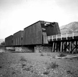
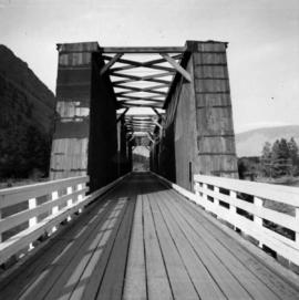
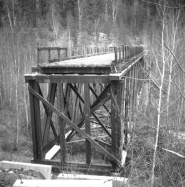
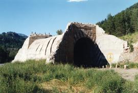
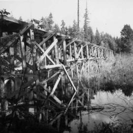
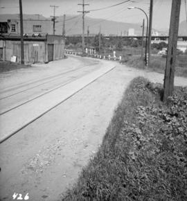
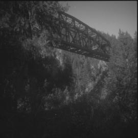
Photograph depicts the former CPR Coquihalla to Brookmere rail line. This view is about 10 miles northeast of Hope. The abandoned bridge has been left to stand in isolation.
Photograph depicts the former CPR depot in Castlegar that was now a museum. Depot rebuilt in 1907.
Photograph depicts a view of former C.P.R. steam locomotive sheds at North Bend, B.C. in the Fraser Canyon.
Photograph depicts the former C.P.R. passenger vessel "Lady Alexandra", now a floating restaurant in Coal Harbour. The Bayshore Hotel is at the right. The picture was taken after a snowfall and shows a view looking east.
Photograph depicts the former C.P.R. route connecting existing False Creek rail yards and the Burrard shoreline main line. The view is looking southwest from the intersection of Powell St. (in foreground) and Columbia St. (not seen) in Vancouver.
Photograph depicts a former dance hall, now barn in the centre of Keremeos Centre. Only 2 buildings of the original village survived which included the dance hall and a hotel across the street.
Photograph depicts a former electric service car of the B.C. Electric Railway located in Chilliwack. It is in remarkably good shape.
Photograph depicts one of three fire hydrants in the former Chinatown in Nanaimo, BC Chinatown was destroyed by a fire in 1955. The hydrant as cast initials, "T.C.I.W."
Photograph depicts a former gang car 'garage' in a station building.
Photograph depicts a former Great Northern Railway bridge, which carried the line over the Similkameen River between Keremeos and Hedley. The bridge is about 2-3 miles west of Keremeos.
Photograph depicts a former Great Northern Railway bridge carrying a single track over the Similkameen River, between Keremeos and Hedley. The bridge is about 2-3 miles west of Keremeos.
Photograph depicts a former highway bridge that was probably made obsolete when the new road to Edmonton was built in 1970.
Photograph depicts a former hotel, 300 yards from the former government wharf, in Squamish, B.C.
Photograph depicts a former icehouse at the Nelson CPR depot. It is located about 150 yards west of the main depot building. It also shows service boxcar CPR #412120, on the right track. The view is looking east.
Photograph depicts a road widening that exposed a concrete rail over/road under a bridge that was originally part of an embankment. Portals were dated 1912 (this side) and 1913 (other side). It was believed that the gap was originally spanned by a wood trestle and then upgraded for an opening of the KVR to the west.
Photograph depicts former KVR track in Summerland. CPR speeders were parked on the main line.
Photograph depicts Lardeau's former depot - Gerrard Railway (CPR) and agents office at the CPR ferry ship in Lardeau. It was last used as such around 1966/67. In the weeds of the foreground, is a disused grain spur which connects to the trackage of the wharf. Rails on this spur are dated 1905.
Photograph depicts a former light ship called "Thomas E. Bayard." Image captured the view of the foredeck and base of the mast holding a light.
Photograph depicts a former light ship called "Thomas E. Bayard." Visible is a schooner before the ship.
Photograph depicts a former logging railroad trestle west of Port Alberni, BC
Photograph depicts a view 1 mile west of Youbou, Cowichan Lake on Vancouver Island, on a former logging railway (or possible C.N. extension). The "yard limit" sign is still standing.
Photograph depictsa former RCAF hanger. Plane was airworthy, only required engine repairs.
Photograph depicts a former RCAF that is not airworthy. It had lost its tail unit.
Photograph depicts a former RCAF that is not airworthy. Its interior was in shambles.
Photograph depicts a CN roundhouse that was built in 1929 at the Kamloops Junction. It was demolished in November, 1993.
Photograph depicts a CN roundhouse that was built in 1929 at the Kamloops Junction. It was demolished in November, 1993. The prime reason for its demolition was not wanting to pay local taxes on a building rarely used for anything except for motor vehicles, general temporary storage, etc.
Photograph depicts a turntable where behind it a former roundhouse stood.
Photograph depicts a former Sailor's Home at the southeast corner of the intersection at Alexander St. and Jackson St. in Vancouver, B.C.
Photograph depicts a former service station on the main street of Pitt Meadows in the Fraser Valley.
Photograph depicts a former store on main street in Pitt Meadows in the Fraser Valley.
Photograph depicts the former "Terminus Hotel" on 32 Water St., 50 yards from the center of old Vancouver.
Photograph depicts former tram tracks down east Georgia St. in east Vancouver, BC
Photograph depicts former tram tracks still intact at east Georgia St. and Campbell Ave. in the east end of Vancouver, BCThe tracks continued forward and crossed the low ground on a trestle.
Photograph depicts former tram tracks, looking north from the intersection at Campbell Ave and east Georgia St. in Vancouver, BC
Photograph depicts former tram tracks in Vancouver, BCPhotograph taken from the intersection of Fir St. and a piece (in the left hand of photo) leading to First Ave., with the B.C. Electric Railway behind.
Photograph depicts former tram tracks at the north end of Fu St. on the south side of False Creek in Vancouver, BC
Photograph depicts locomotive #115, the "Robert E. Swanson," that was built by Lime Locomotive Works in 1934. It was brought to Forst Steele in 1972.
Photograph depicts a coal tub car that was on display in Fort Steele.
Photograph depicts shay locomotive #115. It was running order, but not in steam on the day the photograph was taken. A rod locomotive was found in a shed towards the left. Rails of the spur found in the foreground that led to the shed.
Photograph depicts shay locomotive #115 in steam and with a working engine for the day. It was about to take on water.
Photograph depicts shay locomotive #115. It was running order, but not in steam on the day the photograph was taken. A rod locomotive was found in a shed towards the left, while the "Dunrobin" lay in disuse (but was still workable) in a shed on the rear right.
Photograph depicts Fort Steele in the Kootenays region of British Columbia.
Postcard depicts the Four Tunnels in Fraser River Canyon, BC
Postcard depicts the Four Tunnels over Fraser River, BC
Photograph depicts a frame house in Vancouver. A high rise apartment on Barclay Street was being built and was just appearing in the background.
Photograph depicts the rear view of Ridgewood Studio, Ltd., furnishers and furniture renovators. The wood shed was used for repair and repolishing of furniture.
Postcard depicts Fraser Canyon. "One can catch thrilling sights through the Canyon such as this. Just a few miles south of Lyton, this view offers one some of the Fraser's best scenery."
Postcard depicts Fraser Canyon, BC"The Saddle Rock view shows some of the rugged grandeur on the Canyon route between Hope and Lytton. It's muddy waters, at this time, gathered fourteen large and many small tributaries as it flows to the great Pacific."
Postcard depicts Fraser Canyon in the Canadian Rockies.