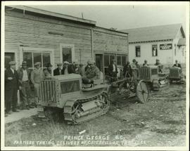
Handwritten annotation on verso of photograph: "PRINCE GEORGE B.C. FARMERS TAKING DELIVERY OF CATERPILLAR TRACTORS." Bob sits on first tractor in line of three. Fifteen men stand in a line against street buildings. "THE SALVATION ARMY" building stands in background on right. This photograph was taken at the corner of 4th and George St.
Photograph depicts two dark horses pulling a loaded sleigh on a snowy road, trees on either side. Bob stands behind them on sleigh. Handwritten caption below this photo reads: "Dec. 1926 Bob with Munroe's team Mud River." Handwritten annotation on recto of photograph: "Robbie & Munro's team B.C. Dec. 1926."
Photograph depicts small boats tied at dock on lake with mountains visible in background.
Photograph depicts boats on river and shore. Riverbank in foreground, buildings and forest on opposite shore in background. Mountains can be seen in distance. Illegible handwritten annotation on verso of photograph. Poor image quality, left portion of image is not visible.
Image depicts several boats on what appears to be a river, and an old beehive burner in Penny, B.C.
Image depicts a boat docked inside what appears to be a type of boathouse, possibly located in Metlakatla near Prince Rupert, B.C.
Image depicts a riverboat on the Fraser River, possibly in Longworth, B.C.
Photograph depicts boat on right, cannery on left, dock crossing midground in front of both. Shore in foreground, hills in background.
Photograph depicts two blasthole drills on bench in mine, old garage visible in centre background. Snow-covered mountain range in background.
Handwritten caption beside this photo reads: "Bear at the Dump". Photograph depicts a black bear facing the camera and sitting alert in clearing.
Photograph depicts Birken Station on the Pacific Great Eastern. It is 113.6 miles from North Vancouver and at an altitude for 1575 ft. The view is looking north.
Photograph depicts Birch Island Bridge over the North Thompson River.
Photograph depicts the only biplane and canavas covered, light aircraft amongst a group of 25 machines in excellent condition.
Photograph depicts a man in snowshoes leading a line of dogs pulling supplies on a toboggan. The second figure, walking behind dogs, is believed to be a man named Fred Burden. Forest trees in background. Handwritten annotation on recto of photograph reads: "Billy Seymour at toboggan". Billy Seymour was a South Fort George man of First Nations descent, employed by the Hudson's Bay Company, and well-known for his ability and endurance in land travel by foot.
Photograph depicts Mr. Barnett seated in floating canoe tied to tree on shore. Forest on opposite shore in background. Handwritten annotation on verso of this photograph reads: "Billy Barnett". It is speculated that this photograph may have been taken on the Fraser River near Giscome Portage, B.C.
Photograph depicts three men guiding canoe through water. Bushes and forest slash in foreground, bushes on swampy shore in background. Handwritten annotation on recto of photograph: "Bill Barnett at stern of canoe."
Photograph depicts Bill and canoe on sandy shore, river and opposite shore in background. Handwritten annotation on recto of photograph: "Billy Barnett at Giscome Portage."
Photograph depicts the Big Bar Creek ferry crossing over the Fraser River.
Rev. William Edwin Collison stands in centre of boat, with wife Bertha and daughters Muriel and Katherine seated behind. Unknown man and woman are also seated in boat, and an unknown man stands on shore holding rope.
Handwritten annotation on verso reads: "Will Collison with wife & children leaving Metlakatla to catch steamship en route to England (1910)".
Handwritten caption above this photo reads: "Bert Youngtrom Pile Driver." Photograph depicts Bert standing on top platform of pile driver apparently without safety gear. Forest trees and white tent in background. Tracks made by machinery cross foreground.
Photograph depicts a hauling truck in wood clearing. Bert Youngstrom can be seen sitting on the passenger side behind a door with "CAMPBELL CONSTRUCTION CO LIMITED" on its side. Handwritten caption beside this photo reads: "Bert Youngstron [sic?]".
Photograph depicts Bert Youngstrom leaning on one of two gas pumps in front of three long buildings. Trees can be seen in background, as well as snow all around. Steel drums an other miscellaneous material surround the buildings. Handwritten captions above and beside this photo read: "Bert Youngstrom" "Shop & Warehouse".
Handwritten caption beside this photo reads: "Bert and Kitchen Staff". Photograph depicts Bert (Youngstrom?) standing close to a woman and young girl on snow in front of unidentified buildings. Forest trees can be seen in background. It is believed that this photo was taken at the camp in Summit Lake, B.C. (see item 2005.3.57).
Item is a photograph of Bert Leboe, MP for Peace River, watching the construction of a trading boat traditionally used in the Peace / Parsnip area. These boats were used to conduct surveys and transport supplies during the construction of the W.A.C. Bennett Dam.
Group of four leans against car. Bert & Sarah Glassey stand to left of unknown woman and man, field and hillside in background.
Photograph depicts benches after strip mining at Cassiar. Drill visible in distance, ore haul trucks on road in foreground.
Item is a photograph of the beltway used to carry aggregate to the Dam site.
Image depicts Bellos Road, most likely in Red Rock, B.C.
Photograph depicts the downtown area in which prior to 1998, the CNR had a loop. It ran west beside Clement and after crossing over Ellis, turned north for a couple of blocks, then turned east, back over Ellis, and along Recreation Street and Weddell.
Image depicts a beehive burner, as well as rail road tracks, at an unknown location.
Photograph depicts the CPR Beaverdell depot located at about 35 miles northeast of Osoyoos and at mile 91.4 east of Penticton on the Carmi Subdivision. The traffic here is ore from a local mine, some lumber, and freight for the village. The depot building is in use and has a telegraph. There is also siding capacity for 31 cars. This section was built between 1914 and 1915. The view is looking north.
Photograph depicts the CPR depot at Beaverdell, located at about mile 42.3 on the Carmi Subdivision. To the right is an ore loader for concentrate from mines. There is no rail traffic at this date. The view is looking north.
Photograph depicts the Beaverdell Bridge, located between Rock Creek and Kelowna, BC
Photograph depicts Beaver Trucking located on Kamloops Indian Reserve No. 1 on Tk'emlups te Secwepemc territory, Kamloops, BC. It had been a company since 1990 and received 2 or 3 boxcars weekly loaded with items from Toronto that were then delivered around town. Davies later noted that the business was destroyed by arson in 1997.
Publication contains report entitled "Bear River Pass Railway Feasibility" created for the District of Stewart.
Image depicts a section of road running through the Bear River Gorge.
Photograph depicts blurry image of a bear among what is believed to be slash piles in the forest. Handwritten caption beside this photo reads: "Supposed to be a bear".
Image depicts the BCR tracks passing through a mill somewhere near the 100 Mile.
Photograph depicts old BC Electric Railway interurbans purchased for restoration by the government of BC from an Oregon owner. They stood in the CPR Duke Street Yards in Vancouver.
Photograph depicts a BCER rail bridge at the entrance to False Creek, Vancouver.
Photograph depicts former BC Electric car barns in New Westminster. In the foreground remained an old flat and possibly a hoist for battery plates.
Photograph depicts a steam crane with a jib in a gondola car. It is en route to an iron works in Burnaby.
Photograph depicts a fitter examing the condition and safety of an old steam crane en route to an iron works in Burnaby, possibly Coast Steel Fabricator Ltd.
Photograph depicts the passing loop and goods shed found at the Milner Siding. The main line had just been uprgaded to take coal units trains to Roberts Bank.
Photograph taken at the west end of Johnston Street at the plant of Arrow Transfer Company Ltd.
Photograph taken looking southwest at the Granville Island to the mainland connection.