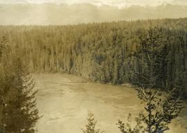
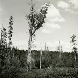
Caption describing photograph: "Overmature Cottonwood growing in alluvial deposit, Bowron River. Coarse silts with fluctuating water table. Low volume of poor quality spruce removed--due to open grown limby form - presently occupied by willow, alder HB cranberry, birch, spirea, water hemlock."
File consists of a reprint of "Overview of Effects of Pacific Coast River Regulation on Salmonids and the Oppurtunities for Mitigation" from the American Fisheries Society Symposium 10.
File consists of an August 1990 copy of a report for the "Overwintering of Juvenile Chinook in the Nechako River, 1989/90 Studies", prepared by Emmett and Convey for Shirvell and DFO.
File consists of a draft copy of a report for the "Overwintering of Juvenile Chinook in the Nechako River, 1989/90 Studies", prepared by Emmett and Convey for Shirvell and DFO. Includes accompanying correspondence regarding the report.
File consists of notes and reproductions relating to the ownership and chronology of Giscome Farm Ltd., on District Lot 9937 Cariboo District in Giscome, British Columbia.
Photograph depicts pipeline construction for the Pacific Northern Gas pipeline from Summit Lake to Kitimat.
Photograph depicts a construction site for the Pacific Northern Gas pipeline from Summit Lake to Kitimat.
Footage of large animal, most likely a moose, along a steep bank. Two men and their pack horse traveling along an open landscape, a close shot of their campfire at night, then footage of them preparing for a journey early in the morning. Also a view of a herd of caribou, the men traveling in a pack train over a stream and through upper valleys of the mountains, various sunset shots, a lake full of birds feeding, and finally the men packing the horses with killed game meat, most likely caribou.
The location of the filming is most likely the Rainbow Mountains.
Photograph depicts twelve or more horses loaded with packs. Three or more men attending. There is a telegraph pole in the midground, treed low hills in the background. The horses are standing in a field.
Photograph depicts packed horses walking on the log jam. [55th parallel]
Photograph depicts eight men standing in a line, loaded with heavy backpacks. There is alpine scrub vegetation in the background.
Photograph depicts a group of horses in process of being loaded with packs. Four or more men attend. There is a canvas tent, open fire and more people in the background.
The footage begins with a man hauling a rubber boat to shore. The man displays the fish that he has caught to the camera. The film cuts to a pontoon plane for Coast Mountain Flight Services Ltd., and then back to the man placing his fish into a bag. The filming then returns to the plane taking off over water. There is aerial footage of the river and mountains, most likely the Bella Coola Valley. Also include is footage of duck with ducklings.
Possible other locations that are seen in the footage are Gitcha Mountains, Ulkatcho Mountains or Rainbow Mountains.
Item is a photograph of a copy print, resulting in a low quality photographic reproduction. Reproduced as a print, slide, and a negative. Location of original photograph is unknown.
Data set consists of data collected for Inlin Brook (sites N04-02, -03, -04) and Red Ochre River (N04-05).
This born-digital document is an unpublished report to the Geological Survey of Canada on field work data and interpretations of Inlin Brook paleosols.
As part of a multidisciplinary team led by Grant Zazula (then a Ph.D. student at Simon Fraser University; later a palaeontologist with the Government of Yukon) and Duane Froese (Professor, University of Alberta), Dr. Paul Sanborn examined a set of buried paleosols (fossil soils) preserved in frozen sediments exposed by placer mining in the spring of 2004.
The findings were published in:
Zazula, G.D., D.G. Froese, S.A. Elias, S. Kuzmina, C. La Farge, A.V. Reyes, P.T. Sanborn, C.E. Schweger, C.A.S. Smith, and R.W. Mathewes. 2006. Vegetation buried under Dawson tephra (25,300 14C yr BP) and locally diverse late Pleistocene paleoenvironments of Goldbottom Creek, Yukon, Canada. Palaeogeography, Palaeoclimatology, Palaeoecology 242: 253–286.
https://doi.org/10.1016/j.palaeo.2006.06.005
The Lost Chicken Mine, a placer gold mine in eastern Alaska, approximately 120 km west of Dawson City, Yukon, is an important fossil locality for the late Pliocene (approximately 2.5 – 3.0 million years ago). A comprehensive account of the stratigraphy and paleontology of this site was given by:
Matthews, J.V., Jr., J.A. Westgate, L. Ovenden, L.D. Carter, and T. Fouch. 2003. Stratigraphy, fossils, and age of sediments at the upper pit of the Lost Chicken gold mine: new information on the late Pliocene environment of east central Alaska. Quaternary Research 60: 9-18. https://doi.org/10.1016/S0033-5894(03)00087-5
Dr. Paul Sanborn visited the site on July 20, 2004, as part of a group led by Duane Froese (Professor, University of Alberta). The group concentrated on a single exposure (~ 2 m thick) straddling the Lost Chicken tephra, a volcanic ash bed (2.9 ± 0.4 myr) which is a major stratigraphic marker at the site. Sanborn described, photographed, and sampled this exposure, and obtained a basic set of characterization data. Intact samples were collected but thin sections were never produced.
Item consists of a recording of the panels "Exploring our Roots: Forest History Research Methodology" (part 2) and "From Exploration to Development: Bringing Forest History Forward" (part 1) at the the "Exploring Our Roots: Forest History in Our Communities Annual Conference of the Forest History Association of BC" at UNBC in Prince George, September 19, 2009.
Item consists of recording of panels "Forest History in our Communities: Robson Valley and Prince George" and "Exploring our Roots: Forest History Research Methodology" (part 1) at the the "Exploring Our Roots: Forest History in Our Communities Annual Conference of the Forest History Association of BC" at UNBC in Prince George, September 19, 2009.
Series consists of materials and records created or collected by Grant Hazelwood in relation to parks and conservation areas in British Columbia. Grant Hazelwood was a BC Parks wildlife biologist and later a consultant via his business, Alpenglow Resources Ltd.; much of his work was in relation to wildlife in parks and conservation areas.
Photograph depicts a bird's eye view of a large river, forest and mountains in the background. On the river's edge there is a scow with several persons standing on it.
Item is a copyprint reproduced from the British Columbia Forest Service photographic records held at BC Archives.
Photograph depicts three or more passengers with sleeping/bed rolls on the deck of the S.S. Nechako sternwheeler. There is a river, riverbanks and low hills in the background.
Photograph depicts view from atop a stage coach, a team of horses pulling a stage coach approaching.
Photograph depicts two freighting stages passing. View is from atop one of the stages.
Image depicts a dam, possibly on the Peace River.
Image depicts a dam on what is possibly the Peace River.
Image depicts the W.A.C. Bennett Dam on the Peace River in Hudson's Hope, B.C.
Photograph depicts the lumber yard at Peden Hill sawmill, likely after the fire that burnt down the first mill at that location.
Photograph depicts two men standing on a wharf. A steamboat is docked, there are rails on the wharf and mountains in the distance.
Item is a photograph of a copy print that has been reproduced as a slide, resulting in low photographic quality. Location of original photograph unknown.
Series contains handwritten notes, remeasurement charts, research reports, journals and cross section books, stump data, diagrams, maps, photographs, logging inspection reports, timber sale contracts, and correspondence.
Series consists of correspondence between Michael Jull, Research Silviculturist, and potential contractors, regarding proposals for the 1993 and 1994 remeasurement of Aleza Lake Growth and Yield Permanent Sample Plots.
Subseries consists of records relating to personnel and human resources issues that were created or accumulated by Adam Zimmerman at the Noranda Inc. (formerly Noranda Mines) corporate office in Toronto. Includes records relating to employment enquiries, employee relations, job postings, turnover rate, and a listing of long-time Noranda employees.
Noranda Inc.File consists of a list of persons involved in the Alcan Kemano controversy and an accompanying letter encouraging the need for a review of the affair.
File consists of Roland Sanford's 1984 University of Washington MSc thesis entitled "PHABSIM Error Analyses: Techniques and Case Studies". Includes accompanying correspondence from Sanford to Shirvell regarding the thesis.
File consists of a copy of MMFA's Phase II Proposal containing a the proposal document, a review of Phase I, a five-year action plan for 1997-2002, indicators of sustainable forest management, and a financial plan for 1997-2002. File includes annotations.
File consists of the "McGregor Model Forest Association Phase III Proposal: Beyond the Boundaries" from Aril 30, 2002. The proposal contains a review of Phase II, and five year action plan for 2002-2007, a financial plan for 2002-2007, and appendices.
Item is an reproduction of the "Phase IV Preamble - July 6, 1994 - Serving to Introduce the B.C.W.F. Brief to B.C. Utilities Commission Technical Hearings on Kemano Completion - Phase III Fisheries Section" by W.G. Hazelwood, Alpenglow Resources, on behalf of Spruce City Wildlife Association, Omineca Region of B.C. Wildlife Federation.
File contains photographs of The Pas Lumber Company Ltd. Includes other northern BC forestry industry images, including Number 5 Timber Ltd. CP625 Block 101, bridge construction, and heavy machinery. Also includes a graphic postcard of Prince George circa 1970s.
Consists of photographs depicting the Grand Trunk Pacific Railway, the Pacific Great Eastern Railway, the British Columbia Railway, the Canadian Pacific Railway, and the Canadian National Railway. Also includes photographs of various forestry-related scenes.
The images consists primarily of 130+ photographs taken by or belonging to Reverend R.W. Large, MD which depict communities on the Northwest Coast between approximately 1898 and 1920 including Bella Bella, Rivers Inlet, and Port Simpson, including native villages in which Reverend Large worked. Images show scenes of native fishing, canneries, mission hospitals, churches, girls schools, portraits of native families, and Northwest Coast totems. Other images include 25+ photographs and postcards from the Large family depicting ships and boats on the North Coast.
Series consists of one black and white photograph of S. B. Trick Lumber Company Sawmill.