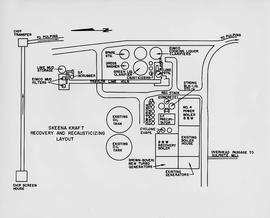
Item is a diagram of the layout of Skeena Kraft recovery and recausticizing.
Pope, Frank L. “Sketch Map Showing the Proposed Route of the Western Union Telegraph Between Fort Frazer and the Stekine River, British Columbia. From exploration by the party under the command of Maj. Frank L. Pope Ass’t Engineer, 1866.
Colour-coded B.C. provincial map depicting sustained-yield units and tree-farm licenses. The area and company names of sustained-yield units (red) and tree-farm licences (green) are explicated in a table.
Item is a map of British Columbia's Status of Sustained-Yield Forestry Programme as at 31 December 1962. The map has been annotated to show forest area surveyed by Celgar Ltd. as base for new kraft mill.
Item consists of a map of British Columbia showing Status of Sustained-Yield Forestry Programme as at December 31, 1969 with colour coded areas indicating Public Sustained Yield Units, Special Scale Areas, Tree Farm Licences, and Major Parks.
Footage of steelhead salmon jumping in river channel. The location is unknown.
Topographic map depicting regions, communities, government posts. bodies of water, transport routes, surveyed areas, and reserves.
Colour-coded topographic map depicting lands surveyed as alienated, available for purchase or lease under Land Act, or reserved. Depicts land district boundaries, land recording divisions, provincial forest boundaries, HBC posts, triangulation stations, telephone lines, communities, bodies of water, and transport routes.
Disc contains a single file, "GGR 2A.ppt", which is a PowerPoint presentation by Gary Runka entitled "The Agriculture Land Reserve: What it is and how it got here" created April 18, 2002.
This "The Land is Yours" film is a promotional film produced by the British Columbia Department of Agriculture in Kelowna, ca. 1968 or 1969. The film was produced by Gary Runka and hosted by Russ Richardson. Runka and Richardson provide commentary throughout the film. The film was directed by Nobert Hartig.
A VHS tape containing "The Mark of Progress" film created by the British Columbia Forest Service and first played for a live audience in 1959 in Prince George, BC.
Map depicts the route of BC Rail and its connecting rail lines.
Topographic map depicting regions, communities, unexplored areas, bodies of water, transport routes, and glaciers.
Attached description: The graph indicates how Skeena Kraft pulping characteristics compare with the burst-tear properties of other bleached kraft market pulps. In this relationship, Skeena Kraft develops the high bursting strength typical of northern Canadian krafts while retaining a distinct advantage in tearing strength.
This data set consists of elemental analysis data for selected B horizons from Wounded Moose paleosols sampled by Tarnocai and Smith. The file includes the original ALS lab report, additional panes showing comparison of replicates, and calculation of a weathering index.