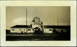
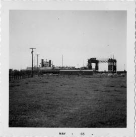
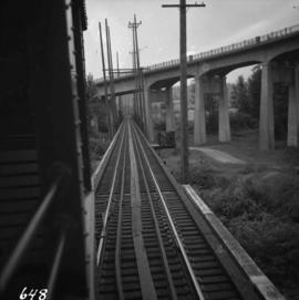
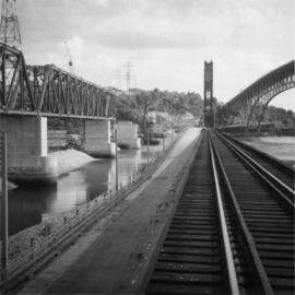
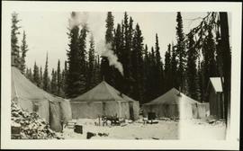
Photograph depicts a tower controlling the C.P.R. grade crossing at Alexander St. in Vancouver, B.C.
Handwritten photo album caption below this photo reads: "Tower & Adm. Bldg, Ft. Nelson." Photograph depicts long white building with tower raised in middle, ladders and scaffolding in front. Trucks and groups of men in foreground, some on building itself. Power poles in foreground and background.
Royal Canadian Air ForcePhotograph depicts a tug boat hauling a line of small fishing boats across the water with a mountain in the background. Annotation on verso of photograph states: "Tow of Cannery Fishing boats"
Totem poles (crest poles?) stand in front of a line of houses. Blanketed canoes sit on beach in right foreground; forest in background.
Handwritten annotations on verso read: “skidegate village Queen Charlotte Islands as it appeared forty years ago"; "Rev W.E. Collison Prince Rupert"; "Hughes"; "1".
Photograph depicts winding river from above, tall trees on either side and mountains in background. Handwritten photo caption on verso and recto of this photograph reads: "Top of Grand Canyon from Portage trail".
Image depicts Highway 16 en route to Prince Rupert, B.C.
Photograph depicts the view of the Tilbury rail terminal on the south bank of the south arm of the Fraser River, 1 1/2 miles east of Deer Island Tunnel. S.S. Canora is also in the picture.
Photograph depicts Tilbury dock on the Delta shore of the Fraser River. The stern of the Canadian National Railway (CN) onboard railcar carrier SS "Canora" is about 10ft away, and showing tidal and moving a piece of dock leading to shore.
Handwritten annotation on verso reads: "Poling supplies up Nass River".
Photograph features three sternwheelers tied to river bank. Buildings visible on far left, hills on shore visible in background.
Printed annotation on recto reads: “Stern Wheelers 1910 Quesnel B.C.” Handwritten annotation on verso in pencil reads: “BX, B.C. Express, Charlotte”
Photograph depicts 3 unnamed railway employees posing for a photograph in front of a railroad station in an unknown location.
Officers are mounted on three horses standing in water. Fifth horse stands on right, trees on shore in background. Handwritten annotation on recto of photograph: "Jas Tracey, Vanderhoof. Srg. Birch."
Ground level view of the Prince Rupert dry dock. Hills are visible in the background. Printed annotation on recto reads: "Three Million Dollar Dry Dock and Shipbuilding Plant, Prince Rupert, BC."
Photograph depicts two men (one in uniform) standing in an airstrip under the nose of a military plane with the number "7632" on its side. A third man stands in uniform on far right, and a building can be seen in distance behind him on the flat horizon. Handwritten photo album caption below this photo reads: "MAJESTIC '32'." It is believed this photograph was taken at the military base in Whitehorse, YT.
Royal Canadian Air ForceItem is a photograph of the three tunnels built to divert the Peace River around the Bennett Dam construction site.
Photograph depicts three crossing at Second Narrows in Vancouver Harbour. On the left was a new CNR bridge being built. In the middle was exsiting CN track. To the right a high level road bridge is visible.
Photograph depicts three B.C. Electric Railway locomotives on running line to the west of car barn at New Westminster.
Photograph depicts CN track 1 mile east of Walhachin. Looking east. Thompson River running downstream, towards the camera. CPR also goes through Walhachin.
Photograph depicts CN track 1 mile east of Walhachin. Looking east. Thompson River running downstream, towards the camera.
Street scene depicting people, boardwalks, horse & wagons, and delivery truck. Printed annotation on recto reads: “3rd Ave. Prince Rupert. B.C.”
Typed annotation in red ink on recto reads: “3rd Ave. Prince Rupert. B.C.” People, boardwalks, horse & wagons and store signs are visible. Rubble and unknown material lies on ground between boardwalks. Typed annotation in red ink on recto reads: “3rd Ave. Prince Rupert. B.C.”
Street view of Third Avenue in Prince Rupert, BC. Several cars are visible parked along the sides of the paved street. Printed annotation on recto reads: "Third Ave. W Prince Rupert- BC."
Elevated view of Third Avenue in Prince Rupert. What appears to be a firetruck is travelling down the road. Printed annotation on recto reads: "3rd Ave W Prince Rupert BC."
Street view of Third Avenue in Prince Rupert. Printed annotation on recto reads: "Third Ave Prince Rupert B.C. Photo W.W.W."
Street view taken from the intersection of Third Avenue and Sixth Street in Prince George BC. A drugstore and several cafes can be seen on the left side of the street. Printed annotation on recto reads: "3rd Ave & 6th Street Prince Rupert BC."
Photo depicts a street perspective of Third Ave., in Prince George, BC, ca. 1950. Handwritten annotation in pen on verso of postcard reads: “You will undoubtedly notice that there are no tall buildings. I don’t think that there is one building in Prince George that is even five stories tall.”
Photograph of a small vessel on the ocean with a dock and harbour buildings in the foreground. Tents and piles of lumber can be seen among the buildings. Annotation on recto reads: "The Wharf, Prince Rupert, BC. 1657."
Image depicts half of a ship, which is named the Tutshi, in Carcross, Y.T.
Stern wheelers “Operator” and “Conveyor” in dock. Printed annotation on recto reads: “S.S. “Operator” and “Conveyer” at Fort George, B.C. No. 107.”
Photograph depicts the split of the Great Northern Railway (GNR) (shown) and the Canadian National Railway (CN) tracks, immediately south of the Fraser crossing at New Westminster.
Map depicts the route of BC Rail and its connecting rail lines.
Side perspective street view of the Royal Hotel in Prince Rupert BC. The "Ladies [sic] Entrance" sign is visible on the right side of the building. Several vehicles can be seen on the street. Printed annotation on recto reads: " 3rd Ave Prince Rupert Photo W.W.W."
Photograph depicts the "Princess of Vancouver" loading at 7 p.m. in Vancouver.
Stern wheeler “Port Simpson” tied to riverbank. Printed annotation on recto reads: “On the Skeena river, Hazelton, B.C.” Handwritten message on verso is addressed to “Mrs. Flossie Strong 6 Nah St. Watermill ME, U.S.A” 1 cent Canadian postage stamp has been canceled with a date of “Dec 24, 5:30 PM 1915 Buffalo N.Y.”
Handwritten annotation on verso reads: " '[Naskeena?' anchored off Metlakatla with Dr. [Mc-?] & Capt. Barry standing on its deck".
Photograph depicts the boat "John Antle" motoring on the water near a rocky, tree covered cliff. Handwritten annotation on verso states: "M.S. John Antle on her rounds entering Smuggler Cove". Stamped annotation on verso reads: “The National Film Board”
Postcard depicts the Canadian Pacific Railway line where the Great Divide between BC and Alberta.
Image depicts the Duchess engine, which was built in 1878 and taken out of service in 1919. It was part of a matched set with the Duke and is now a tourist attraction in Carcross, Y.T.
Group of men stand on pier by warehouse, looking out at the boat. Treed mountains visible in background.
Handwritten photo caption beside image reads: "Danube".
Slightly elevated front-facing photograph of a steam engine and cargo coming into a station in Prince Rupert, BC. Coal and lumber yards are visible in the background. Annotation on recto reads: "The C.N.R. Prince Rupert. 79."
Map depicts location of treasure hidden between Clearwater and Clemina, BC.
Stern wheeler passing through rapids. Printed annotation on recto reads: “The B.C. Express passing through the Grand Canyon B.C.” Handwritten annotation in red ink on recto adds: “1913”
Handwritten annotation in pen on verso reads: "Dad [W.E. Collison] on ‘Naskeena’ – Prince Rupert Harboue en route to Nass River”.
Indian agency boat the “Naskeena” en route to its next destination. Handwritten annotation in pen on verso reads: “ ‘Naskeena’ en route”
Indian agency boat the “Naskeena” off Kitkatla B.C. W.E. Collison, Indian Agent standing at the stern.
Handwritten annotation in pen on verso reads: “‘Naskeena’ Gov. patrol boat off Kitkatla BC. W.E. Collison on stern.”
Image depicts a vehicle on a gravel road somewhere near Tête Jaune Cache, B.C.
Handwritten photo album caption below this photo reads: "Teslin Lake and River, at 11 000 feet." Photograph depicts winding river below, mountain range in background.
Royal Canadian Air ForceImage depicts a rail road bridge located somewhere near Terrace, B.C.
Photo description on accompanying photo album page: " 'Yonge Street' at Teslin Lake, Yukon. The centre tent was used by the radio men. Teslin, 130 miles south of Whitehorse, is the site of one of the aircraft radio stations on the new Edmonton-Whitehorse circuit, paralleling the Alaska Highway."