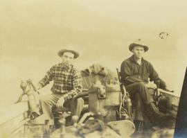
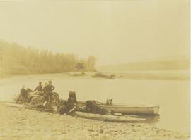
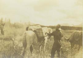
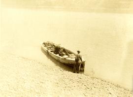
Photograph depicts Mac McGarvey (left) and Frank Dewing (right) getting the boat "Starvation" ready on a rocky shoreline in preparation for travel on the Peace River.
Photograph depicts Mac McGarvey (right) and Frank Dewing (left) seated in a boat on the Peace River. Mac McGarvey is steering the boat while Frank Dewing is pumping water from the boat.
Handwritten caption beside this photo reads: "Lunchroom Damaged by Boulder". Large boulder stands to right of small building, walls of right corner partially destroyed. Lumber, upturned saw horse, and various other material lie on ground. Dirt road in foreground, mountainside in background.
Image depicts two unknown individuals canoeing on the lower part of Spectacle Lake.
Image depicts the lower end of the river channel leading to the Spectacle Lakes.
Handwritten annotation on verso reads: "Lower end of canyon on Naas River. North of Prince Rupert". Forest and mountains visible on shore in distance.
Image depicts a view of the lower Cayoosh Valley.
Image depicts several buildings in the community of Loos, B.C.
Photograph depicts the tops of two trees with a large body of water visible in the background. Annotation on verso of photograph states: "Looking towards the "Head" from Rivers Inlet Hospital"
Photograph depicts an unidentified man with binoculars standing on a snow covered rocky slope searching for game.
Image depicts the post office in Longworth, B.C.
Image depicts several old shacks and some railway tracks running through Longworth, B.C.
Image depicts the Fraser River and a mountain in Longworth, B.C.
Image depicts two unidentified individuals standing next to the train station, and two railway tracks running through Longworth, B.C.
Image depicts numerous piles of wood in Longworth, B.C.
Image depicts four unidentified individuals walking along the bank of the Fraser River in Longworth, B.C.
Image depicts a house surrounded by trees and a mountain in the background; it is most likely located somewhere in or near Longworth, B.C.
Photograph depicts a lone mountain goat climbing up a rocky, striated slope.
Photograph depicts one unidentified man surveying a landscape from a snowy mountain peak with other mountain ranges in the background.
Image depicts a pile of old logs on the bank of the Fraser River with mountains in the background. In the foreground, a set of railway tracks run through an uncertain location, likely Upper Fraser, B.C.
Annotation on slide: "Summit Lake, March 1992".
Image depicts numerous piles of logs, and two unidentified individuals operating an excavator with a "thumb" attachment during the demolition of the Upper Fraser town site. Map coordinates 54°06'51.6"N 121°56'26.3"W
Fully loaded logging truck driving along a wood plank logging road. Another road under construction is also visible through forest in background.
Fully loaded logging truck driving along a switchback, wood plank logging road.
Handwritten annotation in pencil on verso reads: “Truck Logging / Giscome BC.”
Image depicts an area undergoing logging somewhere in Prince George, B.C.
Image depicts a logging area somewhere near Prince George, B.C.
Annotation on slide: "[mostly illegible] Km 3 [?] pinker [?] cubic block"
Annotation on slide: "Summit Lk".
No annotation on slide.
Photograph depicts a forested mountain, the bottom half of which has been logged and terraced; beneath the mountain is a railroad track and parked vehickes including a schoolbus and two dumptrucks.
Handwritten annotation on verso reads: “Fairview Sodturning, Prince Rupert, 1/3/75”.
Annotation on slide: "Log skidding on main haul road, Fleet Creek Trial SS054, Jan. 1995"
Photograph depicts four long logs crossing flowing water, rocks and bush on opposite shore in background. Handwritten annotation on recto of photograph: "Canyon Creek near 4th Cabin".
Image depicts a log cabin and an orange truck somewhere in or near Longworth, B.C.
These historically important aerial photographs depict Williston Lake soon after its creation in 1968 with the building of the W.A.C. Bennett Dam on the Peace River. Also depicted are the rivers and tributaries that empty into the Williston Reservoir, such as the Finlay River, the Ospika River, and the Omineca River.
These remote-sensing aerial photographs were taken by Lockwood Survey Corporation Ltd. under contract for the B.C. Forest Service. Some photographs are annotated to show logging activity; clearcuts, slash piles, log booms, and tree debris on the water are also visible in some of the images. No detailed location information or index accompanies the photographs.
Lockwood Survey Corporation Ltd.File consists of a paper titled "Local Government in the Yukon and Northwest Territories" presented by Weller at the 1983 Western Social Science Association conference. This file was originally numbered to correspond with conference paper number 25 listed in Weller's CV.
File consists of a paper titled "Local Government in the Canadian Provincial North" presented by Weller at the 1980 Western Social Science Association conference. This file was originally numbered to correspond with conference paper number 14 listed in Weller's CV.
Photograph depicts a man loading up pack horse with two other laden pack horses visible in the periphery of the image.
Footage of men preparing pack horses for a hunting trip in the early morning hours.
Possible locations of filming are Holt Homestead or Lassard Lake.
Photograph depicts five men loading packed bags into a long boat belonging to Mac McGarvey. The boat is resting near the shore of an inlet at Rolla Landing.
Six men visible on hillside and wood plank roadway, working together to roll cut logs down the hill and load them onto the truck.
Handwritten annotation in pencil on verso read: “logs up to 32 feet in length.”
Film begins with aerial footage of mountains believed to be around Bella Coola. Then recording of men loading barrels, supposedly of gas, into a boat using a "home made" winch and boom construction. They ferry the barrels up stream, the river is assumed to be Dean River. and use a similar construction to bring the barrels to shore.
There is also footage of men fishing in the river.
Photograph depicts a loader filling a truck with dirt from the damaged road near Moricetown.
Photograph depicts a loader dumping dirt from a damaged road near Moricetown.
Photograph depicts a pack horse train heading up a snow-covered path along a mountain trail. The environment around the sloping mountain trail is sparsely covered with trees.
Photograph depicts a train of pack horses carrying loaded packs and walking up a mountain trail.