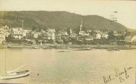
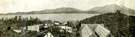
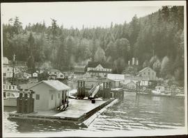
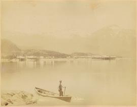
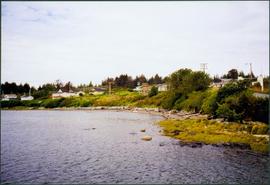
Buildings and harbour visible across water. Unknown man stands in a small boat in foreground, mountains visible in background.
Photograph depicts a woman in visiting attire with hat and umbrella. Sandy area in foreground. Fence, trees, building, and wagon in background.
Photograph depicts two women standing on wood boardwalk with a jack russell terrier. Bushes and neighbouring yards in background.
Photograph depicts an elderly woman standing beside two younger women who kneel beside small girl on front yard. Trees, car, road, and neighbouring yards visible in background. Young girl speculated to be also featured in item 2009.5.2.5.
Item is a hand drawn and coloured map by the City of Prince George Planning Department depicting existing land use for the Van Bow neighbourhood area.
Item is a hand drawn and coloured map by the City of Prince George Planning Department depicting existing zoning for the Van Bow neighbourhood area. Also includes two hand-drawn mylar overlays for the map; one showing "Opportunities & Constraints" such as housing age and condition and the other showing "Subdivision Activity" over decades of development in the Van Bow area.
Item is a map depicting the Vancouver Carney study neighbourhood area in Prince George.
Item is a map depicting land use in the Vancouver Carney study neighbourhood area in Prince George. Also includes two mylar overlays that show the outlines of "unit 2" and "unit 3" development areas.
Photograph taken during European Sports Tour with Team Canada.
Photograph taken during European Sports Tour with Team Canada. See also item 2009.6.1.241 for image featuring similar content.
Handwritten annotation on verso reads: "Budapest". See also item 2009.6.1.238 for image featuring similar content. Photograph taken during European Sports Tour with Team Canada.
Hand coloured view of early Prince Rupert with row of tents facing large Hotel. Printed annotation in red ink on recto reads: “The Beginning of Prince Rupert B.C.: Grand Trunk Pacific Hotel in foreground”.
Lofty view of South Fort George, river and treed hills in the background. Printed annotation on verso reads: “South Fort George - 1913.” Handwritten message on recto is addressed to “Ethel M. Heurris Norton Maps Bristol County" reads: "11-1-13 an excellent view of south Fort George taken recently. Power Station at cross near water. This does not give all the south residence view. Population approx 1500”.
Lofty view of Fort George, B.C., river and paddle wheeler on right. Treed hills can be seen in background. Printed annotation on verso reads: “Fort George B. C.”
View of town on shore, from above. Boats docked along piers and buildings. Hills visible on either side of water in background.
Handwritten photo captions with arrows pointing to sections of image read: "General Merchandise", "Fort Wrangell Hotel".
Town on right, water on left, mountains in background. Forest trees in foreground.
Handwritten photo caption below image reads: "Port ESSINGTON".
Photograph depicts buildings along shore; bridge and boardwalk cross forest in right foreground. Hills visible in distance.
Handwritten annotation below image reads: "Port Essington from bridge"; on verso: "Heading or full page Illustration Chapter XXIII No2".
Photograph depicts shore and village with a treed hill in the background. Water and boats in foreground. Handwritten annotation in ink on verso of photograph: "Port Simpson B.C.". Semi-legible annotation on recto notes the postcard was addressed to London, England.
Photograph depicts Port Simpson in winter. Water crosses midground, hills stand in background.
Handwritten photo caption below image reads: "Port Simpson".
View of pier, cluster of houses and trees with snow topped mountains in background. Handwritten annotation on verso reads: “Hospital” with an arrow pointing to the building. Postage cancelation stamp on verso reads: "PORT ESSINGTON B.C. JUL 7 07". Handwritten annotation on recto reads: “PORT SIMPSON. Mrs. Noble Port Essington B. C. Hope you are feeling better. I am doing splendidly have not felt so well for years. Dr. advises me to stay at least another month A.W.B.”
Boardwalk in foreground, buildings and roads in mid ground, cut banks in background. Printed annotation on recto reads: “Prince George. B.C. 1921 by Moore”. Handwritten annotation in ink on verso reads: “The Netchaco river is between the mountain and the city and the C.N.R. runs along the river bank nearest the city. This picture is taken looking north.”
River in foreground, railroad and city in mid ground and hill in background. Printed annotation on recto reads: “Prince George. B.C. 1924”
Winter landscape taken from behind railroad track. Cleared land in foreground, buildings in midground, low hills in background.
Handwritten annotation on recto: “PRINCE GEORGE 3-15-14”.
Winter landscape taken from behind railroad track. Cleared land in foreground, buildings in midground, low hills in background.
Handwritten annotation on recto: “PRINCE GEORGE 3-15-14”.
River crosses midground, hills on distant shores can be seen in background.
Handwritten annotation on verso reads: "No. 32, First Beginning Prince Rupert, showing Church Hall, with cross. Insert Page 136".
Lofty view of Prince Rupert BC. Water crosses midground, hills stand in background. Printed annotation on recto reads: “Prince Rupert BC McRae Bros”.
Lofty view of Prince Rupert BC. Water crosses midground, hills and opposite shore in background. Printed annotation on recto reads: “Prince Rupert BC McRae Bros”.
Winter scene with buildings, street, and utility poles. Hill in background.
Handwritten annotation on verso: “South Ft. George 1912”.
View of the road descending to the waterfront. Buildings and forested area are visible on either side of street. Mountains clear in the background.
Photograph depicts a row of houses and fenced yards on right, separated from more buildings on left by grassy area.
Printed on image: "Metlakahtla Nr. Prince Rupert. Allen Photo June '11"; handwritten annotation on verso reads: "Metlakatla B.C. North West Coast of America / Collison".
Photograph depicts community buildings on shoreline, water in foreground.
Handwritten annotation on image reads: "Wrangle, Alaska."; on verso: "Fort Wrangle, Alaska Territory. visited by W.H.Collison, C.M.S. 1877. Prior to the establishment of any mission, [...? illegible] 1875 - 1876. Presbyterian. Insert this illustration of Wrangle on Page 77 as marked."
Photograph depicts water in foreground, bayside village in background.
Handwritten annotation on recto of photograph: "Here they are in Sleeping beauty asleep. Virginia is not all in. She is behind Violet who is King. Father of the beauty. That is the queen in front and the nurse at the head of the bed and the Beauty on the bed." The girls are in costume on material laid out in snow in front of unidentified building. Unknown wood object in left foreground.
Lucy stands next to Violet on far right in group with six other unidentified young girls. Each girl wears a white dress and holds a holly branch. They stand on material laid out in snow in front of unidentified building. Handwritten annotation on recto of photograph: "Violet. Lucy. This is their Holly and Mistletoe Drill".
Photograph depicts group of fourteen men and women dressed in formal attire, posed on carpet in front of backdrop. Violet sits second from left. This photograph was taken in Prince Rupert where Violet attended high school while living with her relatives Sarah and Herbert Glassey.
Drawing depicts visual notes taken at the 2020 Public Health Summer Institute with the theme "Think Globally, Act Locally: Public Health and the Anthropocene". Themes related to the COVID-19 pandemic are depicted.
This street map of the VLA area in Prince George includes property outlines and street numbers.
Item is a hand drawn and coloured map by the City of Prince George Planning Department depicting the VLA neighbourhood proposed zoning in 1976.
Item is a hand drawn and coloured map by the City of Prince George Planning Department depicting zoning proposed by Prince George Alderman A. Stauble for the VLA neighbourhood.
Item is a hand drawn and coloured map by the City of Prince George Planning Department depicting zoning proposed by the Prince George City Planner for the VLA neighbourhood.
Item is a hand drawn and coloured map by the City of Prince George Planning Department depicting public representations at the VLA neighbourhood zoning hearing that occurred on April 12, 1976.
Group of six men sit and stand on small boat close to shore. Rev. W.E. Collison stands on far right (son of Marion and Archdeacon W.H. Collison).
Handwritten annotation on verso reads: "Dr. Macdonald Med officer (Kincolith) / Dr. [McQuarrie?] Med officer Victoria / Steven Clayton Native boat owner / Capt. Bary - Insp. of Indian Schools / W.E. Collison Indian agent. / Inspection trip to villages of upper Nass River".
Rev. W.E. Collison sits to left of totem pole, smoking a pipe (oldest son of Marion and Archdeacon W.H. Collison). Log fence can be seen in front of forest in right background.
Handwritten annotations on verso read: “W.E. Collison at Massett, QCIs."; "Dad beside totem pole".
Group poses between two buildings, small dog visible behind. Wood piles and tree stumps can be seen on hill in background.
Handwritten annotation on verso reads: "Metlakatla BC / Back row - W.E. Collison, Fr. Hogan, ?, ? Canon Keen / Front row - ?, ?, Bishop Du Vernet, Archdeacon Laycock". See also item 2009.7.1.32 for image featuring Father Hogan, and 2009.7.1.29 for image featuring Bishop Du Vernet.
Group of eight men wearing suits and ties pose with Reverend Collison (oldest son of Marion & Archdeacon W.H. Collison).
Handwritten annotation on verso reads: “Rev. W. E. Collison & his Lay Readers at Massett, Q.C.Is.”
Photograph depicts a wharf and buildings along the shore of an unidentified fishing community with a forested environment visible in the background.
Warf construction visible in foreground. Background consists of a few built structures and several tents, location unidentified.
Unidentified individuals can be seen walking and sitting behind arches. One man lies on street in foreground.
Photograph is one of 11 images taken during a World Health Organization (WHO) trip, Human Rights of Women and Children, Peru, 1990. Possibly affiliated with World Council of Churches, International Ecumenical Delegation to Lima, Peru, 14-25 October 1990. See also items 2009.6.1.505 - 2009.6.1.515.