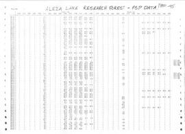
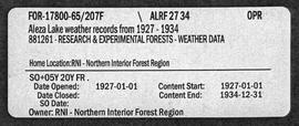
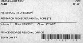
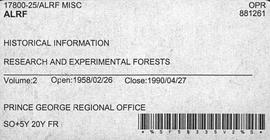
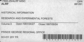
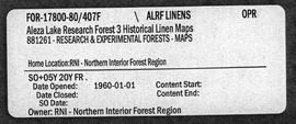
Maps reflect reserve boundary, roads, trails, 20 feet contour intervals, air photo centre, declination, swamps, and mile post.
File contains charts consisting of the remeasurements of the basal area and cut stump data in permanent sample plots.
File contains handwritten journal lists of remeasured permanent sample plots and charts of remeasured permanent sample plots.
File contains research project reports and charts of remeasured permanent sample plots.
File contains typed file notes and charts of remeasured experimental plots, as well as a floppy disk
File contains official government reports on tree types, correspondence regarding research proposals, and working plans.
Item is a computer print-out of PSP data from Aleza Lake Research Forest.
File contains road reconstruction project reports, photocopies of invoices and work orders, records of daily costs, photocopies of hired equipment daily time reports, related correspondence, and maps.
File consists of chainsaw-cut stump data in selected plots for June and July 1993 and May 1994.
File contains climate data of soil and air temperatures, correspondence relating to climate studies, original and photocopied receipts for items related to the study, and computer generated graphs.
File contains reports on soil rehabilitation project and related correspondence, photocopied tables of soil measurements, and photocopied pages of ledgers with diagrams and notes.
File contains reports on soil rehabilitation projects and related correspondence, photocopied tables of soil measurements, and reports on machinery costs when tilling.
File contains original tables for soil measurements, a related photocopied draft report, and related photocopied handwritten notes.
File contains photocopies of seedling measurement tables.
File contains proposal updates and project expenditure lists.
File contains photocopies of survey notes from 1954.
File contains 1996 charts of permanent sample plot remeasurements.
File contains 1991 regeneration data of permanent sample plots and a 1992 work term study report on the significance of the basal area on regeneration factors.
File consists of documents, radiograms, and correspondence regarding various administrative issues ranging from costs, living conditions, timber sales, research projects, and queries from the public. Much of this correspondence is between Tim Decie, Forester in Charge of Aleza Lake, and R.P Silsbury, Head of the Research Division between the years of 1953 and 1967. Also included are contracts and receipts from 1964, documents regarding the closure of the Aleza Lake Experiment Station, and meeting minutes.
File contains Aleza Lake Research Forest weather records from 1927 to 1934 and 1928 to 1933.
File contains reports and essays on certain research projects ranging from the year 1924 to 1984. The topics of these research projects include cutting methods, guidelines for marking techniques, and scarification.
File contains articles and government publications on the results of research projects and policies regarding the Aleza Lake Experiment Station with years ranging from 1945 to 1992. Also included are a photocopied 1926 progress report, a 1967 management manual, and guides pertaining to trails and marking stands for cutting.
File contains a 1997 field tour guide of the Aleza Lake Research Forest, and 1997 and 1998 government publications on research projects conducted at the forest.
File consists of:
- David Mills, "Aleza Lake Research Forest Historical Internship Summary" (2 Jan. 2007), 26 p. - In print and original digital .doc file
- David Mills, "Aleza Lake Forest Experiment Station Socio-Economic Time Line 1905-1937" (2007), 68 p. - In print and original digital .doc file
- ALRFS employment paperwork for David Mills, the ALRFS Natural Resource History Intern
- Research notes, including a copy of a map of the town of Aleza Lake in the 1920s
This PDF contains site location data, annotated soil profile photographs, and AMS radiocarbon dates for 2004 soil charcoal samples collected at Kluane Lake, Yukon Territory.
This PDF contains site location data, annotated soil profile photographs, and AMS radiocarbon dates for 2008 soil charcoal samples collected at Kluane Lake, Yukon Territory.
Item is "An Analysis of the Difference in Gross Merchantable Cubic-foot Volumes of the Upper Fraser Uneven-aged Spruce-Balsam Type When Computed by 2-, 4-, 6-, and 8-inch D.B.H. Classes" from the BC Forest Service "Research Notes" series.
Unpublished results for the Sulphur stable isotope tracer study (E.P. 886.15) were presented in annual reports to the funding agencies, including this FII Final Report from April 2003.
Item is an original "Atlin Park Lake Trip Report" by W.G. Hazelwood. Includes original photographic prints pasted into the report.
File contains correspondence relating to project funding and reports on the significance of the project.
Item is a draft of "B.C. Hydro Proposed 287 kV Transmission Line - Kitimat to Terrace - Preliminary Environmental Assessment of Fish and Wildlife Values" by Grant Hazelwood. Also includes accompanying print pages for a 2015 BC Hydro powerpoint slideshow regarding the Terrace to Kitimat Transmission Project (TKTP).
Item is an original report by Rob Cannings entitled "Biological Investigations of the Blue Rivers Headwaters Area, Wells Gray Park". Includes original photographic prints within the report.
File consists of climate station data printed from computer disks, original and photocopied soil description forms, and original copies of ecological and terrain mapping reports.
File consists of budget proposals and forecasts for 1993/94 and 1994/95 with recommendations of road maintenance as the central expenditure.
Item is a reproduction of a report entitled "Burns Bog Analysis" by Catherine Berris & Associates for the Ministry of Environment, Lands & Parks. The scope of this Burns Bog Analysis was inventory and preliminary analysis; the process included information collection and review, preliminary analysis of existing and potential land uses and a public open house.
Photographs are panoramas taken from the Churchill BC Forest Service Lookout, located at latitude 54°04' and longitude 122°16'. The photographs were bound together and include a transparent grid that was intended to be used for locating forest fires.
This document file "Cluculz Creek Fertilization Research Site.pdf" contains a field description and basic characterization data for a representative pedon at the E.P. 886.10 site.
Item is "Cluculz Lake Silviculture Demonstration Area Trail Guide" by the BC Ministry of Forests.
File contains reports on the analysis of permanent sample plots in the Aleza Lake Research Forest.
File contains general correspondence from 1981 through 1998 regarding various administrative issues including road maintenance and the 1992 reopening of the Aleza Lake Research Forest. The file also contains a 1994 inventory of the Northwood donation to the Fraser-Fort George Museum.
Item is an original report by Grant Hazelwood and Steve Head regarding "Crooked River Fisheries and Wildlife". Includes one original photographic print pasted into the report. This project was aimed at improving the recreational use of the Crooked River and it's adjoining corridor.
Item is a reproduction of a report entitled "Delta Nature Reserve: Evaluation Study Prepared for Delta Parks and Recreation". This study was intended to provide information and make recommendations regarding the optimum use of the property.
This document provides study descriptions, lab data, and images for sites Y04-01 to Y04-04 for the paleosols at the Goldbottom site study.
Item is a photocopied version of Slavoj Eis' "Development of White Spruce and Alpine Fir Seedlings on Cut-Over Areas in the Central Interior of British Columbia" reprinted from The Forestry Chronicle, December 1965, Vol. 41, No. 4.
Item is an original "Do's and Don't's When Marking Stands For Cutting" booklet illustrated by J. Pickford.
Item is an original report by Teuvo Ahti entitled "Ecological Investigations on Lichens in Wells Gray Provincial Park, with Special Reference to their Importance to Mountain Caribou". Includes accompanying correspondence between Ahti and his BC Parks employers regarding travel and contract details.
Item is the 1958 BC Forest Service report from Myra, BC titled "E.P. 160 & 503: Development of a Residual Stand of Interior Spruce-Alpine Fir During the First 28 Years Following Cutting". This report is the follow-up to the 1926 and 1936 reports titled "Conditions After Logging of a Spruce-Balsam Forest in Relation to Spruce Reproduction and to the Rate of Growth of the Second Story".
Item is the 1957 version of the BC Forest Service report from Myra, BC titled "E.P. 160: Conditions After Logging of a Spruce-Balsam Forest in Relation to Spruce Reproduction and to the Rate of Growth of the Second Story" by R.F. Stettler.