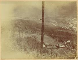
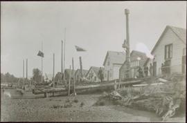
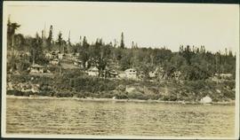
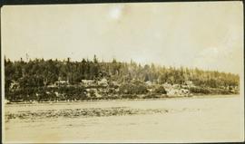
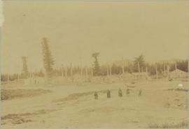
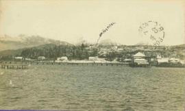
Winter landscape taken from behind railroad track. Cleared land in foreground, buildings in midground, low hills in background.
Handwritten annotation on recto: “PRINCE GEORGE 3-15-14”.
Winter landscape taken from behind railroad track. Cleared land in foreground, buildings in midground, low hills in background.
Handwritten annotation on recto: “PRINCE GEORGE 3-15-14”.
Winter landscape taken from behind railroad track. Cleared land in foreground, buildings in midground, low hills in background.
Handwritten annotation on recto: “PRINCE GEORGE 3-15-14”.
River in foreground, railroad and city in mid ground and hill in background. Printed annotation on recto reads: “Prince George. B.C. 1924”
Boardwalk in foreground, buildings and roads in mid ground, cut banks in background. Printed annotation on recto reads: “Prince George. B.C. 1921 by Moore”. Handwritten annotation in ink on verso reads: “The Netchaco river is between the mountain and the city and the C.N.R. runs along the river bank nearest the city. This picture is taken looking north.”
View of pier, cluster of houses and trees with snow topped mountains in background. Handwritten annotation on verso reads: “Hospital” with an arrow pointing to the building. Postage cancelation stamp on verso reads: "PORT ESSINGTON B.C. JUL 7 07". Handwritten annotation on recto reads: “PORT SIMPSON. Mrs. Noble Port Essington B. C. Hope you are feeling better. I am doing splendidly have not felt so well for years. Dr. advises me to stay at least another month A.W.B.”
Photograph depicts Port Simpson in winter. Water crosses midground, hills stand in background.
Handwritten photo caption below image reads: "Port Simpson".
Photograph depicts shore and village with a treed hill in the background. Water and boats in foreground. Handwritten annotation in ink on verso of photograph: "Port Simpson B.C.". Semi-legible annotation on recto notes the postcard was addressed to London, England.
Photograph depicts buildings along shore; bridge and boardwalk cross forest in right foreground. Hills visible in distance.
Handwritten annotation below image reads: "Port Essington from bridge"; on verso: "Heading or full page Illustration Chapter XXIII No2".
Town on right, water on left, mountains in background. Forest trees in foreground.
Handwritten photo caption below image reads: "Port ESSINGTON".
View of town on shore, from above. Boats docked along piers and buildings. Hills visible on either side of water in background.
Handwritten photo captions with arrows pointing to sections of image read: "General Merchandise", "Fort Wrangell Hotel".
Lofty view of South Fort George, river and treed hills in the background. Printed annotation on verso reads: “South Fort George - 1913.” Handwritten message on recto is addressed to “Ethel M. Heurris Norton Maps Bristol County" reads: "11-1-13 an excellent view of south Fort George taken recently. Power Station at cross near water. This does not give all the south residence view. Population approx 1500”.
Lofty view of Fort George, B.C., river and paddle wheeler on right. Treed hills can be seen in background. Printed annotation on verso reads: “Fort George B. C.”
Hand coloured view of early Prince Rupert with row of tents facing large Hotel. Printed annotation in red ink on recto reads: “The Beginning of Prince Rupert B.C.: Grand Trunk Pacific Hotel in foreground”.
Photograph taken during European Sports Tour with Team Canada. See also item 2009.6.1.241 for image featuring similar content.
Handwritten annotation on verso reads: "Budapest". See also item 2009.6.1.238 for image featuring similar content. Photograph taken during European Sports Tour with Team Canada.
Photograph taken during European Sports Tour with Team Canada.
Item is a map depicting land use in the Vancouver Carney study neighbourhood area in Prince George. Also includes two mylar overlays that show the outlines of "unit 2" and "unit 3" development areas.
Item is a map depicting the Vancouver Carney study neighbourhood area in Prince George.
Item is a hand drawn and coloured map by the City of Prince George Planning Department depicting existing zoning for the Van Bow neighbourhood area. Also includes two hand-drawn mylar overlays for the map; one showing "Opportunities & Constraints" such as housing age and condition and the other showing "Subdivision Activity" over decades of development in the Van Bow area.
Item is a hand drawn and coloured map by the City of Prince George Planning Department depicting existing land use for the Van Bow neighbourhood area.
Photograph depicts an elderly woman standing beside two younger women who kneel beside small girl on front yard. Trees, car, road, and neighbouring yards visible in background. Young girl speculated to be also featured in item 2009.5.2.5.
Photograph depicts two women standing on wood boardwalk with a jack russell terrier. Bushes and neighbouring yards in background.
Photograph depicts a woman in visiting attire with hat and umbrella. Sandy area in foreground. Fence, trees, building, and wagon in background.
Buildings and harbour visible across water. Unknown man stands in a small boat in foreground, mountains visible in background.
Photograph depicts town buildings and church on shore to right of river winding through hills. Metal bar speculated to be part of a bridge crosses foreground.
Landscape featuring town buildings below on right. A farmyard can be seen in foreground.
Photograph depicts a man and woman standing beside an elderly woman on wood boardwalk near front porch. Neighbouring yards in background.
Photograph depicts a man and woman standing beside an elderly woman on grass lawn. Wood boardwalk runs beside house, steps and porch featured on left. A jack russell terrier stands at their feet. Neighbouring yards in background.
Photograph depicts a man and woman standing beside an elderly woman on wood boardwalk near front porch. Window plants hang beside them and a jack russell terrier sits at their feet. Neighbouring yards in background.
Photograph depicts a man and woman standing beside an elderly woman on boardwalk running alongside house. Window plants in foreground, neighbouring yards in background. A jack russell terrier stands in left foreground.
Photograph depicts an empty canoe floating beside a canoe full of fish. Hills visible on opposite shore in distance.
Handwritten annotation on verso reads: "Loaded with fish - Nass River".
Photograph depicts an unidentified man standing on the porch of a large house in front of a forest.
Photograph depicts unidentified man with glasses reclining on blanket, coats hanging behind him. Some type of shelving or roofing can be seen in background. Man is wearing pants, belt, and striped shirt with a pencil in the pocket. It is speculated that this man may be Bert Youngstrom, (see items 2005.3.4 & 2005.3.59).
Photograph depicts a woman holding fur, standing beside three men on steps to unidentified building. Door and windows in background.
Shoreline perspective of an unidentified coastal village situated on B.C.’s north coast. European style houses run parallel to a rocky shore. Seven men and one child stand within this frame and totem poles and a mortuary pole are also visible along the shoreline.
Unknown buildings can be seen in background.
Photograph depicts many buildings among forest trees on hillside of opposite shore. River in foreground.
Photograph depicts baseball game, batter in mid-swing,and buildings visible in background. Handwritten annotation on recto of mounted slide reads: "Base ball game in Lejac". See also items 2006.20.1.199 - 2006.20.1.202 for images featuring similar content.
Four women and one child stand on shore in foreground. Village buildings and totem poles (crest poles?) stand in background against forest.
Photograph of a half-demolished building attached to a large dock. A large group is milling around the damage. Debris litters the water. Annotation on recto reads: "Undesired result of big blast at Prince Rupert. August 13 1908. Allen Photo."
Woman on left wears a name tag while holding ice cream cone. Photograph taken at unidentified outdoor function, see also items 2009.6.1.630 - 2009.6.1.634.
Photograph depicts two boys standing on platform extending into lake. Buildings and fenced areas can be seen on shore in background. Handwritten annotation on recto of mounted slide reads: "boys playing on the lake / Legac".
Team on left pulls wagon with the sign "RUDDY & MACKAY. BAGGAGE. STAGE & TRANSFER." Driver believed to be same man featured in items 2009.5.1.79 & 2009.5.1.81. A second man sits in wagon on luggage. Team on right pulls a man driving a buggy. A large three story building with detailed porch stands in background behind teams in street.
Photograph depicts two unidentified men walking across a large log over water at Knight's Inlet. Handwritten annotations on verso read: “W.C. Baker, Chaplain”; “Knights Inlet, 23 April 1960"
Photograph of two men relaxing on some short exterior stars. A surveying transit can be seen in the background.