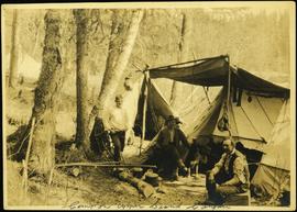
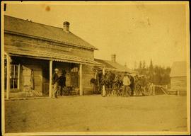
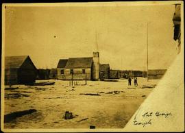
Affichage de 841 résultats

Archival description
841 résultats avec objets numériques Afficher les résultats avec des objets numériques
Business on Street in Atlin, BC
2009.5.2.88 · Pièce · 1899
Fait partie de Taylor-Baxter Family Photograph Collection

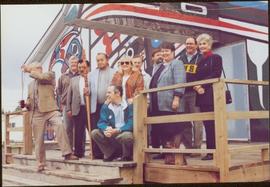
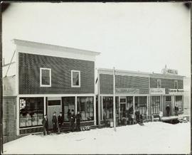
Photograph depicts group of men in hats and ties standing on wood deck connecting four store fronts. Left to right: Parsons Produce Co., Dunn & Co. Hardware and Tinware, Fortin & LeGappelain Druggists, Cummings & Richardson - Gents, Furnishings, Boots and Shoes. Handwritten annotation on recto of photograph: "Branch Parsons Produce Co at Atlin 1899."

Camp at Summit Lake, B.C.
2005.3.57 · Pièce · [ca. 1945]
Fait partie de John Hart Highway Photograph Collection

Photograph depicts a numerous variety of buildings in snowy clearing of forest. A car is parked in foreground on road leading into the camp. Handwritten caption beside this photo reads: "Sumit Lake Camp". It is speculated that this may be the Campbell Construction Co. road camp.

Camp at Summit Lake, B.C.
2005.3.61 · Pièce · [ca. 1946]
Fait partie de John Hart Highway Photograph Collection

Photograph depicts the camp at Summit Lake, B.C., a numerous variety of buildings in snowy clearing of forest. A car is parked in foreground on road leading into the camp. It is speculated that this may be the Campbell Construction Co. road camp.

2011.3.2.20 · Pièce · [ca. 1910-1924]
Fait partie de North Coast & Central BC Postcard Collection

Street view photograph of a commercial section in downtown Prince George with several "Campbell's" delivery carts parked along the road. Visible establishments include "Campbell's All Cash Store" and "Club Cafe." Handwritten annotation in blue ballpoint pen on recto reads: "Howdy from Prince George! Going easy with all these kids- good to see Kathee. Snow here. Have fun at the sports show & don't over do it. Thinking of you guys, love Judy and Vic. P.S. Can't wait to go home to somewhere peaceful and quiet. 2-27-83." Postcard is addressed to: "Mr. & Mrs. Hauffer 8429-221 PL. Sn. Edmonds, WA. U.S. 98020." Verso is affixed with four Canadian 8-cent stamps.

Campsite Buildings in Forest
2005.3.69 · Pièce · [ca. 1946]
Fait partie de John Hart Highway Photograph Collection

Photograph depicts five long buildings in forest clearing, lining left of a road down the center of the image. Wood piles are stacked against buildings. Men can be seen in distance near a white tent.

2009.7.1.161 · Pièce · [ca. 1880 - ca. 1915]
Fait partie de Archdeacon W. H. Collison fonds

Canoes sit on shore in foreground beside village buildings. A dock is visible above water in background.

Handwritten annotation on verso reads: "Alert Bay Indian Ranch No. 14 Alert Bay. To be shown on page 69 or 70, re Alert Bay Mission."

2006.20.12.18 · Pièce · [ca. 1940]
Fait partie de Northern BC Archives Historical Photograph Collection

Handwritten photo album caption below this photo reads: “The Next Morning.” Photograph depicts man believed to be Captain Read, arms linked with a second unidentified man in uniform. The two men are standing on wood slat sidewalk in front of building with many windows speculated to be barracks [see item 2006.20.12.16] at Fort St. John. This photograph was beside item 2006.20.12.19 which depicts unidentified man in this photo and a second man, ready to go out for the evening.

Sans titre
2006.20.9.6 · Pièce · 19 October 1911
Fait partie de Northern BC Archives Historical Photograph Collection

Photograph depicts two, four-horse stagecoaches laden with passengers parked outside the Hotel Northern in South Fort George. A group comprised of primarily men watch the stagecoaches from the veranda of the hotel. Handwritten annotation in bottom right corner of photograph reads: "Cariboo Stage at South Ft. George, BC. Oct 19-1911."

Cassiar Valley, Tree Silhouette
2000.1.1.3.13.04 · Pièce · [before 1970]
Fait partie de Cassiar Asbestos Corporation Ltd. fonds

Photograph depicts the Cassiar townsite behind shadow in foreground. Plantsite can be seen including the mill, dry rock storage building, tailings pile, and many other buildings. Mountains in background. Handwritten annotation on recto: "<- 13 1/2" ->". (This photograph was made into a promotional poster.)

Catholic Church in Prince Rupert, BC
2009.5.2.58 · Pièce · [ca. 1913]
Fait partie de Taylor-Baxter Family Photograph Collection

Photograph depicts Catholic church, with rectory on its left, and First United Church behind. A wood boardwalk crosses midground, and a man can be seen riding a bicycle near church. Power lines and rough cleared land in foreground, hills and mountains in background. Handwritten annotation on recto of photograph: "Church in Rupert."

Central Avenue, Fort George, BC
2011.3.2.09 · Pièce · 1913
Fait partie de North Coast & Central BC Postcard Collection

Printed annotation on recto reads: “Central Avenue Fort George B.C. Copyright Canada June 25th 1913”. Handwritten annotation in ink on recto reads: “Hotel Fort George; Pool room; Men’s furnishing; General store; Bank Vancouver; Telephone office; Temperance House; Trust-company; Grand stand & fair grounds; Hospital; Ware house and general store.” Cancelled 1 cent Canadian stamp on verso is dated: "Fort George BC Jul 14 13". Handwritten message in ink on verso is addressed to Mr. Chas H Wilson 94 Gould St Toronto: "Fort George. B.C> Box 65, July 13/ 13. Dear Father, This is a 'bird's eye view' of our main street - ha! ha! some class alright. We live right behind the bakery lunch room on the right hand side of the picture, on 1st avenue, some people eh? Will be moving to Cassiar Ave soon. How are all the folks. Mae is writing. Peace. M."

Centre Street on Dominion Day
2009.7.1.300 · Pièce · 1 July 1909
Fait partie de Archdeacon W. H. Collison fonds

Photograph of Centre Street in Prince Rupert on Dominion Day. The Union Bank of Canada is located on the left side of the street, and a decorative arch can be seen in the background. Annotation on recto reads: "Centre Sr. Prince Rupert Dominion Day Celebrations 1909 Allen Photo July 09."

Centre Street Prince Rupert
2009.7.1.251 · Pièce · ca. 1880-1920
Fait partie de Archdeacon W. H. Collison fonds

Photograph of residents in motion on Centre Street in Prince Rupert. Buildings are visible on either side of the street and a railway track runs down the length of the road. Annotation on recto reads: "Centre Street, Prince Rupert, BC. 1664."

2009.6.1.551 · Pièce · [1992?]
Fait partie de The Honourable Iona Campagnolo fonds

Two unidentified woman are also visible with the group, on far left and in centre with arm raised. Young girl sits on post in foreground. Photograph was taken during the chancellor's tour of Xats'ull Heritage Village, Soda Creek First Nation, Williams Lake, B.C.

2009.6.1.553 · Pièce · [1992?]
Fait partie de The Honourable Iona Campagnolo fonds

Left to right: Charles Jago and unidentified woman, David Fish, Dennis Macknak, Deborah Poff, unidentified woman and child, Iona Campagnolo, Lee Morrison, Ellen Facey, two unidentified women. Teepees visible in background. Photograph was taken during the chancellor's tour of Xats'ull Heritage Village, Soda Creek First Nation, Williams Lake, B.C.

Changing Horses on the Cariboo Road
2009.5.3.24 · Pièce · [ca. 1914]
Fait partie de Taylor-Baxter Family Photograph Collection

Photograph depicts four men standing near fully packed horse-drawn cart in front of wood buildings, including a long building with a porch and chairs. Trees on hill visible in background. Handwritten annotation on recto of photograph: "Changing teams on the Cariboo Road".

2009.7.1.108 · Pièce · [ca. 1878 - ca. 1915]
Fait partie de Archdeacon W. H. Collison fonds

Chief Gideon stands in suit and tie behind his wife who sits on the ground in front. Fence with chicken wire crosses midground, building visible in background.

Handwritten annotation on verso reads: "Chief Gideon & his wife on upper Nass River".

Children at play
2009.7.1.164 · Pièce · [ca. 1910]
Fait partie de Archdeacon W. H. Collison fonds

Seven young boys enjoying a game of tug-a-war alongside a wooden track. Track runs along a picket fence through a village. A small girl watches the fun from the sidelines and older woman carries a basket in the background. Handwritten annotation in pen on verso reads: “Native children at play”.

Children gathered at Metlakatla Church
2009.7.1.056 · Pièce · [between 1874 and 1901]
Fait partie de Archdeacon W. H. Collison fonds

Several unidentified individuals can be seen on front steps of church and a group of small children in white stand in line below steps. Other community buildings are visible in background, white fence crosses foreground. Photograph depicts the first church built in Metlakatla, which was burned in a fire in 1901, and replaced in 1903.

Handwritten annotation on verso reads: "Church (of England) at Metlakahtla - British Columbia. Built by the people of the village - largest church then on the pacific coast."

Children gathered at Metlakatla Church
2009.7.1.057 · Pièce · [between 1874 and 1901]
Fait partie de Archdeacon W. H. Collison fonds

Several unidentified individuals can be seen on front steps of church and a group of small children in white stand in line below steps. Other community buildings are visible in background, white fence crosses foreground. Photograph depicts the first church built in Metlakatla, which was burned in a fire in 1901, and replaced in 1903.

Handwritten annotation on verso reads: "Old church at Metlakatla Before fire. Built by Fr. Duncan & the village people".

Church at Fort George Reserve, BC
2009.5.3.29 · Pièce · [ca. 1912]
Fait partie de Taylor-Baxter Family Photograph Collection

Photograph depicts two men standing in street at the Fort George Reserve. A church with steeple stands in midground, on left side of street. Forest in background. Handwritten annotation on verso and recto of this photograph reads: "Fort George Temple." See item 2009.5.3.28 for photograph depicting this reserve which belonged to the Lheidli T'enneh Band.

2023.5.1.28 · Pièce · 1 Nov. 1993
Fait partie de UNBC School of Planning and Sustainability fonds

This map is part of Schedule B of the 1993 Official Community Plan, Bylaw No. 5909 for the City of Prince George. This particular map depicts the central area of the City of Prince George, including the Bowl area, the VLA, the Crescents, South Fort George, Heritage, and Peden Hill.

2023.5.1.29 · Pièce · 1 Nov. 1993
Fait partie de UNBC School of Planning and Sustainability fonds

This map is part of Schedule B of the 1993 Official Community Plan, Bylaw No. 5909 for the City of Prince George. This particular map depicts the northeast area of the City of Prince George, including the industrial areas on Prince George Pulpmill Road and Northwood Pulpmill Road along the Fraser River.