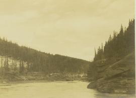
Photograph depicts the Peace River leading up to a strait called the "Gate" at Lynx Creek. The narrow strait is flanked by a forested, rocky shoreline.
Photograph depicts the Peace River Canyon with the Peace River in the foreground and rocky, tree-lined cliffs flanking the river. In the background a forested mountain base is visible.
Photograph depicts the Peace River curving around the tree-covered cliffs at the Peace River Canyon.
Image depicts a street of shops at an uncertain location somewhere in the Peace River Regional District. A pink and blue building, possibly a theatre, is labelled "Lux."
Image depicts grass burning at an uncertain location in the Peace River Region.
Image depicts a section of forest located somewhere in the Peace River Regional District of B.C.
File consists of research materials on Pehr Kalm, a botanist.
Image depicts rail road tracks and several buildings in Pemberton, B.C.
Image depicts the condominiums in the "Pemberton Valley Estates" in Pemberton, B.C.
Image depicts a beehive burner somewhere in or near Penny, B.C.
Image depicts a red boat on a river, possibly the Fraser, near Penny, B.C.
Image depicts four unidentified individuals standing on the bank of a river, possibly the Fraser, somewhere in or near Penny, B.C.
Image depicts a river, possibly the Fraser, near Penny, B.C.
Image depicts Sue Sedgwick standing in front of an old, run-down house somewhere in or near Penny, B.C.
Image depicts a group of people heading towards a glacier, possibly the Robson Glacier.
Image depicts a group of people standing on a hill, with what is possibly Mt. Robson in the background.
Image depicts a group of unknown individuals with a mountain in the background.
Image depicts a man talking to a group of hikers, with what is possibly Mt. Robson and the Robson Glacier in the background.
Image depicts a group of people observing splintered wooden boards at an uncertain location.
Image depicts a group of people standing on the foot of a glacier, possibly the Robson Glacier.
Image depicts a group of people on the rocky bank of a river somewhere near Mt. Robson.
Percy Garland (married Ellen Taylor) stands with snowshoes and Husky dog in snowy area in front of two trees.
Image depicts an individual, possibly Sue Sedgwick, standing next to a very thick and tall tree somewhere on Haida Gwaii.
Image depicts an individual standing on a trail in the coastal forest on Haida Gwaii, B.C.
Image depicts an individual ducking under a tree branch somewhere in Haida Gwaii, B.C.
Image depicts an individual walking on a a log bridge in a forest somewhere on Haida Gwaii.
Image depicts an individual walking on a path through a forest somewhere on Haida Gwaii.
File consists photos of birds, flowers, travel photos, and some research materials.
Series contains two diplomas awarded to Dr. Ainley by the University of Northern British Columbia, news clippings, and photographs. Series also includes some of her activities during her retirement including her art exhibits, a cruise, and membership in Federation of BC Writers.
File consists of a list of persons involved in the Alcan Kemano controversy and an accompanying letter encouraging the need for a review of the affair.
File consists of material relating to the use of pesticides in Canada. Materials include newspaper clippings, and a magazine. Highlights include:
- Ministry of Forests, "ForesTalk", Vol.6 No. 3 1982 (magazine)
Photograph depicts two men (possibly Pete Callao and Carrol Paul) standing with two saddled horses. In the background a mountain vista is visible.
Photograph depicts Pete Callao (left) and Frank Dewing (right) napping under a spruce tree lean-to in a forest clearing.
Photograph depicts Pete Callao using an axe to cut a trail through an area covered with windfall.
Photograph depicts Pete Callao on horseback looking through binoculars in order to determine his course through a forested valley to Pine River. In the background the peak of a mountain is visible.
File consists of magazine article about Peter Latz, an Australian botanist.
File contains slides depicting the Peyto Glacier.
File consists of two original copies (one in English, one in French) of "Peyto Glacier: General Information" prepared by Kent Sedgwick and E.S. Hencock for Environment Canada. Includes attached supplementary map along with each publication. Also includes duplicate original maps in the file.
File contains slides depicting landforms at various locations.
Image depicts an aerial view of areas that have been used for logging around Prince George, B.C.
Image depicts an aerial view of the Ahbau area somewhere near Prince George, B.C.
File contains slides depicting the grade for what was formerly the Pacific Great Eastern, and is now known as British Columbia Railway.
Image depicts a view of the south direction of the grade for the British Columbia Railway, which was formerly known as the Pacific Great Eastern until 1972. It is at an uncertain location, possibly near Woodpecker or Prince George.
File consists of Roland Sanford's 1984 University of Washington MSc thesis entitled "PHABSIM Error Analyses: Techniques and Case Studies". Includes accompanying correspondence from Sanford to Shirvell regarding the thesis.
This remote-sensing aerial photograph was taken by Lockwood Survey Corporation Ltd. under contract for the B.C. Forest Service. This historically important aerial photograph depicts the headwaters of Williston Reservoir soon after its creation in 1968 with the building of the W.A.C. Bennett Dam on the Peace River.
The identification coding on these photographs can be interpreted as follows:
- The largest number on the leftmost side is the frame number for the photograph.
- The following code to the right in the format B) 69-53 is currently unknown, but may refer to an internal project number for the Lockwood Survey Corporation.
- The 6" may refer to the camera's focal length in inches.
- Next is "17,150 ASL" which is 17,150 feet Above Sea Level.
- Following is "152.52" which refers to the camera's focal length in millimeters, which equals 6 inches.
- The "W1307" may refer to the reel, but that is unconfirmed.
- "8 SEP 69" is the date the photo was taken.
This remote-sensing aerial photograph was taken by Lockwood Survey Corporation Ltd. under contract for the B.C. Forest Service. This historically important aerial photograph depicts the W.A.C. Bennett Dam and Williston Reservoir soon after its flooding in 1968.
The identification coding on these photographs can be interpreted as follows:
- The largest number on the leftmost side is the frame number for the photograph.
- The following code to the right in the format B) 69-53 is currently unknown, but may refer to an internal project number for the Lockwood Survey Corporation.
- The 6" may refer to the camera's focal length in inches.
- Next is "17,150 ASL" which is 17,150 feet Above Sea Level.
- Following is "152.52" which refers to the camera's focal length in millimeters, which equals 6 inches.
- The "W1307" may refer to the reel, but that is unconfirmed.
- "8 SEP 69" is the date the photo was taken.