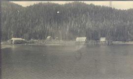
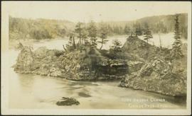
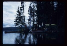
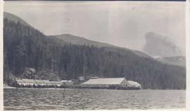
Photograph depicts cannery buildings on pilings with a body of water in the foreground and tree covered mountains in the background.
Photograph depicts cannery buildings on wooden pilings with a body of water in the foreground and a forested area in the background.
Photograph depicts a building under construction with wood planks on the dock in the foreground and a forested area in the background.
Photograph depicts a distance perspective of several cannery buildings with a body of water in the foreground and a mountain range in the background.
Photograph depicts a line of cannery fishing boats being towed across the water with the base of a mountain in the background.
Photograph depicts an empty canoe floating directly in front of small white tents on opposite shore. Forest trees in background.
Image depicts a house located somewhere in or near Canoe Creek.
Image depicts a view of Canoe Creek.
Photograph depicts a small pass through an island or peninsula on the Fraser River. Photo is believed to have been taken near Stone Creek, south of South Fort George. Annotation on verso of photograph reads: "FORT GEORGE CANYON. CANOE PASS. J. HEAY. PHOTO."
Riverboat floats in midground, canoes float by shore. Trees and hillside on opposite shore in background. Poor image quality.
Image depicts a view of the ridge above the Fraser River which forms the Grand Canyon, B.C.
Image depicts a car on a dirt road leading through a forest.
Photograph depicts car on water's edge at bottom of incline, possibly damaged, with back doors open. Trees and bushes in foreground.
Image depicts Bennett Lake near Carcross, Y.T.
Photograph taken at terrace gardens, Government House in Victoria, B.C.
Image depicts a log house at an uncertain location; the slide is simply labelled "Cariboo."
Image depicts the Cariboo Falls.
Image depicts the Cariboo Lake, with the roof of an old log cabin visible.
Image depicts the Cariboo River.
Image depicts the old, grown-over Cariboo Road at an uncertain location.
Image depicts the Cariboo Road south of Williams Lake.
Image depicts the Cariboo Road at Hat Creek Ranch, near Highway 99 on the way to Lillooet.
Image depicts the Cariboo Road in Soda Creek, B.C.
File consists of records and textual material related to caribou (predominantly in British Columbia) collected by Grant Hazelwood. Highlights include:
- BC Ministry of Environment, "Woodland Caribou in the Thompson-Nicola Resource Region", June 1981
- R.W. Ritcey, "Caribou and Forest Management in British Columbia", Jan. 1974
- W.G. Hazelwood, "Northern Tweedsmuir Park Flight - October 9, 1979"
- William Low, "A General Ecological Study of Mountain Caribou in Tweedsmuir Provincial Park, British Columbia", Mar. 1965 (reproduction)
- W.G. Hazelwood, Northwood Pulp and Timber, "Caribou Flight - March 19, 1980"
- Grant Hazelwood, manuscript notes for caribou flight over the Stikine, Mt. Edziza, Dease Lake areas, 9. Oct. 1979
- Report prepared for Dupont of Canada, "Caribou Studies in the Vicinity of Lawyers Pass, Northcentral B.C., Sept. 1980 to Aug. 1981", Mar. 1982 (reproduction)
- Spatsizi Association for Biological Research, "1980-81 Progress Report No. 8"
- Deborah Cichowski, "Habitat Use, Winter Feeding Ecology and Population Status of Woodland Caribou in West-Central British Columbia", 1990
- Dale R. Seip, "Ecology of Woodland Caribou in Wells Gray Provincial Park", Mar. 1990
Footage of a large caribou bull in what is believed to be the Rainbow Mountains.
Footage of a caribou herd.
Probable locations of filming include the Chilcotin area, Rainbow Mountains, or Tweedsmuir Provincial Park.
Footage of a herd of caribou running on mountain plateau, probably the Rainbow Mountains. Also various clips of hunting camp and the men loading their pack horses.
Footage of caribou herd on an open landscape.
Location is speculated to be the Ulkatcho Mountains, Rainbow Mountains or Tweedsmuir Provincial Park.
Image depicts a small slope on Carney Hill in Prince George, B.C.
Image depicts miocene gravels on Carney Hill in Prince George, B.C.
Image depicts Carp Lake.
Image depicts two boats on the shore of Carp Lake.
Image depicts a campsite on the shore of Carp Lake.
Image depicts Carp Lake at dusk.
Image depicts a green canoe sitting in the water on the shore of Carp Lake.
Image depicts a man holding a chain of fish on the shore of Carp Lake.
Image depicts a low rain cloud over Carp Lake.
Image depicts a low rain cloud over Carp Lake, and a man on a boat on the lake.
File consists of a typescript report in a duotang titled "Carp Lake Park Report: 1973" by Leon E. Pavlick.
File contains slides depicting images of areas in the Carp Lake Provincial Park.
File consists of outgoing correspondence from BCUC to the Carrier Sekani Tribal Council and the Cheslatta Carrier Nation. Also includes incoming correspondence to BCUC from tribal council and the Cheslatta Band, as well as their representatives.
File consists of the second draft of a transcript of the meeting between the Department of Fisheries and Oceans (represented by Bell-Irving, Fretwell, and Blacket), the Aluminum Company of Canada (represented by Bill Rich, Brian Hemmingway, Doug Bruchet, Bruce Jenkins, and Clyde Mitchell), and the Carrier Sekani Tribal Council (Edward John, Justa Monk, Morris Joseph, et al) regard studies conducted by the Department of Fisheries and Oceans and the Aluminum Company of Canada Ltd. on the Nechako River and its resources. Document sent to Hartman by John Hummel, Cheslatta Band researcher, who included an accompanying letter. Annotated by John Hummel.
Photograph depicts Carrol Paul (left) and George Bates (right) standing with pack horses loaded with bull moose meat. In the background a burnt forest is visible.
Photograph depicts Carrol Paul (left) and George Bates (right) holding rifles and standing beside two felled bull moose. In the background a sparse forest is visible.
Photograph depicts Carrol Paul (right) and Harry Snyder (left) sitting on the ground during a tea break. In the background is a forested area filled with coniferous trees.
Photograph depicts Carrol Paul fishing along the banks of a river. In the background is a forested shoreline.