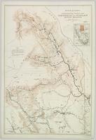
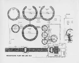
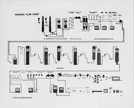
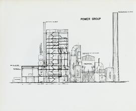
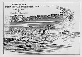
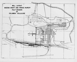
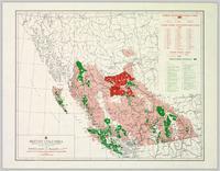
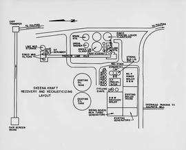
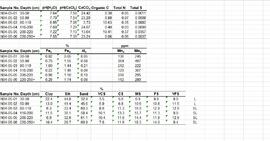
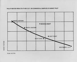
Attached description: The graph indicates how Skeena Kraft pulping characteristics compare with the burst-tear properties of other bleached kraft market pulps. In this relationship, Skeena Kraft develops the high bursting strength typical of northern Canadian krafts while retaining a distinct advantage in tearing strength.
Topographic map depicting regions, communities, unexplored areas, bodies of water, transport routes, and glaciers.
Map depicts the route of BC Rail and its connecting rail lines.
A VHS tape containing "The Mark of Progress" film created by the British Columbia Forest Service and first played for a live audience in 1959 in Prince George, BC.
This "The Land is Yours" film is a promotional film produced by the British Columbia Department of Agriculture in Kelowna, ca. 1968 or 1969. The film was produced by Gary Runka and hosted by Russ Richardson. Runka and Richardson provide commentary throughout the film. The film was directed by Nobert Hartig.
Disc contains a single file, "GGR 2A.ppt", which is a PowerPoint presentation by Gary Runka entitled "The Agriculture Land Reserve: What it is and how it got here" created April 18, 2002.
Colour-coded topographic map depicting lands surveyed as alienated, available for purchase or lease under Land Act, or reserved. Depicts land district boundaries, land recording divisions, provincial forest boundaries, HBC posts, triangulation stations, telephone lines, communities, bodies of water, and transport routes.
Topographic map depicting regions, communities, government posts. bodies of water, transport routes, surveyed areas, and reserves.
Item consists of a map of British Columbia showing Status of Sustained-Yield Forestry Programme as at December 31, 1969 with colour coded areas indicating Public Sustained Yield Units, Special Scale Areas, Tree Farm Licences, and Major Parks.
Item is a map of British Columbia's Status of Sustained-Yield Forestry Programme as at 31 December 1962. The map has been annotated to show forest area surveyed by Celgar Ltd. as base for new kraft mill.
Colour-coded B.C. provincial map depicting sustained-yield units and tree-farm licenses. The area and company names of sustained-yield units (red) and tree-farm licences (green) are explicated in a table.
Pope, Frank L. “Sketch Map Showing the Proposed Route of the Western Union Telegraph Between Fort Frazer and the Stekine River, British Columbia. From exploration by the party under the command of Maj. Frank L. Pope Ass’t Engineer, 1866.
Item is a diagram of the layout of Skeena Kraft recovery and recausticizing.
Reports as follows: Number 2. Report of the Exploration from Quesnal to Lake Tatla, via Natla and Nakosla, by Major Frank L. Pope. 1865. Title page, map, and pages 1-36. (Pages 15-17: Indian tribes; pages 32-36: vocabulary of "Siccany" (Sekani) tribe, living n. w. of Lake Tatla.) Number 3. Report of the British Columbia and Stekine Exploring Expedition, by Major Frank L Pope. 1866. Title page and pages 1-42. (Pages 27-28: Indian tribes; pages 29-30, Trading with Indians.) Number 4. Report of the Lake Babine and Skeena River Exploration, by Captain James L. Butler. 1866. 19 pages. Number 5. Report of the Atnah & Northern Explorations, by Captain J. Trimble Rothrock. 1866. 10 pages. Number 6. Report of Provisions Expended by the Stekine Exploring party; and proposed plan of an exploration from the Stekine to the Youkon, by George Blenkinsop. 1866. 8 pages, including map.
Chismore, George. "Record of travel from Skeena Mouth to Peace River mines." George Chismore Papers. 1871-1900. Bancroft Library, University of California, Berkley. BANC MSS 81/24p.
Details from Bancroft Library:
Include: journal of journey to Peace River Mines, British Columbia, June-Dec. 1871, with descriptions of mines and mining, encounters with Indians, and an account of performing surgery on an injured miner; eleven journals, 1883-1893, primarily of hunting trips to Rogue River, Oregon, and one journal of trip to Siskyous, with descriptions of wilderness, life in hunting camp, account of associations with black ex-slave woodsman-hunter of Rogue River area; journal of trip to St. Petersburg, Russia, June-Sept. 1898, with descriptions of museums, churches, palaces, impressions of life in St. Petersburg, Moscow and other European cities; journal of trip to Panama, Jan.-March 1900; collection of speeches to Bohemian Club; collection of his poems, ca. 1897. Also includes articles about Chismore's medical career. (32p.)
Mckay, Joseph William. "Recollections of a chief trader in the Hudson's Bay Company." 1878 Hubert Howe Bancroft Collection. Bancroft Library, University of California, Berkley. BANC MSS P-C 24.
Details from Bancroft Library:
McKay came from Canada to Fort Vancouver in the Hudson's Bay Company service in 1844. Describes disturbed conditions in the old Oregon country, in consequence of the American influx; duties in 1845-1846 escorting British officers; visit to San Francisco and Hawaii in 1846 on Company business; Frémont's activities; experiences in charge of Fort Simpson, 1846-1849; relations with the Russian American Company and Indians of the Northwest Coast; duties on Vancouver Island, 1850; discovery of gold on Queen Charlotte Island, 1851, and of coal at Bellingham Bay, 1853; life at Fort Simpson during the Crimean War. Includes typed transcript. (21p. )
Item is a diagram of recausticizing plant and lime kiln.
Item is a diagram showing the process through chip preparation and continuous digesting, brown stock washing, brown stock screening and cleaning, bleach plant, and bleach stock screening and cleaning.
Colour-coded map depicting lands surveyed as alienated, reserved, and having a timber license, lease, or sale. Depicts land recording divisions, land district boundaries, communities, bodies of water, and transport routes. Includes insets of Stephens Island and Egeria Reach.
Map depicting surveyed lands, statutory timber lands, land recording divisions, game reserves, communities, bodies of water, and transport routes. Includes inset of McBride townsite.
Colour-coded map depicting surveyed lands respectively open and closed to preemption. Depicts land recording divisions, game reserves, communities, bodies of water, and transport routes. Includes inset of McBride townsite.
Colour-coded map depicting lands open for preemption, in “University Reserve,” or reserved for public auction. Depicts land recording divisions, communities, bodies of water, and transport routes.
Colour-coded topographic map depicting lands surveyed as alienated, reserved, or statutory timber land. Depicts land district boundaries, land recording divisions, HBC posts, triangulation stations, telephone lines, communities, bodies of water, and transport routes. Defines resource type areas (“Land Form,” “Soil,” “Forest Cover,” “Grazing,” “Geological & Mineralogical,” “Fur-Bearing Animals & Game”). Includes explanatory “Natural Resources Reference.”
Colour-coded map depicting surveyed lands respectively open and closed to preemption. Depicts land recording divisions, land district boundaries, government reserves, communities, bodies of water, and transport routes. Includes topographical inset.
Colour-coded topographic map depicting lands surveyed as alienated, reserved, or open to preemption. Depicts land districts, land recording divisions, communities, bodies of water, communication lines, and transport routes.
Colour-coded map depicting surveyed lands alienated, reserved, in B.C. Land Settlement Board Area, or open for preemption. Depicts land districts, land recording divisions, communities, bodies of water, transport routes, and communication lines.
Colour-coded map depicting lands open for pre-emption, lands in “University Reserve,” and lands reserved for public auction. Depicts land recording divisions, communities, bodies of water, transport routes, and game reserves.
Colour-coded map depicting lands surveyed as alienated, reserved, Statutory Timber Lands, B.C. Land Settlement Board Area, or open for pre-emption. Depicts land districts, land recording divisions, communities, game reserves, bodies of water, transport routes, and communication lines.
Item is a labeled diagram of the power group at a mill.
Colour-coded topographic map depicting surveyed lands alienated, available for purchase or lease, or available for pre-emption. Depicts land districts, land recording districts, parks, communities, bodies of water, transport routes, communication lines, and triangulation stations.
Data set consists of data collected for Inlin Brook (sites N04-02, -03, -04) and Red Ochre River (N04-05).
Large-format map depicts Northwood Pulp & Timber operating areas in 1975.
Regional map depicting communities, parks, customs posts, airports, radio stations, hatcheries, bodies of water, transport routes, communication lines, elevation points, and lines of batholith contacts. Includes an inset of St. Elias Mountains. Includes “Special Note on the Mineralization of this Map Area” from Bureau of Mines, Victoria, B.C.
Regional map depicting land recording divisions, communities, bodies of water, transport routes, elevation, and lighthouses.
Colour-coded topographic map depicts surveyed lands alienated, available for purchase or lease under Land Act, and available for pre-emption. Depicts land districts, land recording districts, provincial forests, parks, triangulation stations, communities, bodies of water, transport routes, and communication lines.
Large-format map depicts the Monkman Public Sustained Yield Unit (PSYU) and Tree Farm Licence 30 east of Prince George.
Large-format map depicts the Monkman Public Sustained Yield Unit (PSYU) east of Prince George.
Swanton, John Reed. “Materials relating to the Haida.” [1898?]. Manuscript 4117-a, National Anthropological Archives, Smithsonian Institution.
Cooper, James. “Maritime matters on the Northwest Coast and affairs of the Hudson’s Bay company in early times.” 1878. Hubert Howe Bancroft Collection. Bancroft Library, University of California, Berkley. BANC MSS P-C 6.
Details from Bancroft Library:
Describes his maritime service with the Hudson's Bay Company from 1844, and the early development of Victoria and Vancouver Island. Primarily an account of the Hudson's Bay Company control over the region and the evolution of local and provincial government.
(32p.)
Map depicts the routes of the Pacific Great Eastern Railway, showing stations, railway connection, and the PGE Microwave Communication System.
Wyld, James. "Map of the Colony of New Caledonia and the British & American Territory West of the Rocky Mountains including Vancouvers Island and the Gold Fields" by James Wyld, Geographer to the Queen & the Prince Consort, Charing Cross East & 2 Royal Exchange, London, July 16, 1858.
Item is a map that distinguishes the regions covered by Tree Farm Licence No. 1 granted to Columbia Cellulose and Three Farm Licence No. 40 granted to Skeena Kraft. Major locations indicated in this map include: Prince Rupert, Terrace, Hazelton, Smithers, Kitimat, Skeena River, and Nass River. Railway routes are also shown.
Chismore, George. "Log-book of a trip among the Siwash of British Columbia." George Chismore Papers. Bancroft Library, University of California, Berkley. BANC MSS P-K 219.
Details from Bancroft Library:
Logbook of "a trip among the Siwash of British Columbia" (August 31-September 28, 1866), on the way to join, as surgeon, the Western Union Telegraph Company's expedition for the Russian Extension; record of a hunting trip to Old Tongass, March 3-9, 1870, and of a prospecting trip in British Columbia, June 25-July 20, 1870; a paper read before the Geographical Society of the Pacific in 1881, "From the Nass to the Skeena [Stikine]." An obituary clipping relates to Dr. Chismore's practice of medicine in San Francisco after 1873. (25p.)
Item is a map showing the watersheds of Diana Lake, Rainbow Lake and Prudhomme Lake.
Audio recording is of an interview by Bridget Moran with Ken Rutherford, educator and former municipal politician of Swift Current Saskatchewan. Rutherford was an Alderman prior to becoming Mayor of Swift Current from 1944-1952, he ran unsuccessful for the CCF in 1960 and later for the NDP. Rutherford ran for political office in BC in the electoral district of Fort George in 1963 unsuccessfully against Liberal MLA Ray Williston. The interview includes biographical information as well as memories of his career as a school teacher, his political aspirations and involvement with the CCF and later the NDP and the history of medicare in Canada.
Audiocassette Summary
- Rutherford provides genealogical information on grandfather and his mother (her family was from Moose Jaw, Saskatchewan)
- Discusses his parent’s marriage
- Recalls schooling in Swift Current, Saskatchewan where he eventually becomes principal
- Rutherford notes he never went to university, but went to Normal School
- Talks about his wife and children
- Donley Hill
- Recalls joining the CCF and distributing pamphlets; recalls 1935 election and CCF getting few votes
- Recalls salary troubles at the school in Swift Current in the 1930s and being both the teacher and janitor
- He was Mayor of Swift Current from 1944-1952; and previously as Alderman and ran for the CCF in the federal election in 1953;
- Recalls spoiled ballots in the election
- Recalls getting involved with the issue of health premium payments in Swift Current c.1940s.
- Recalls the history of the fight for health care in Canada; and strike in Saskatchewan by doctors
- Recalls the national fight for Medicare – 1961
- Discusses Tommy Douglas; Mackenzie King
- Health care issues