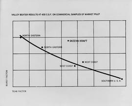
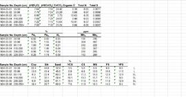
This data set consists of elemental analysis data for selected B horizons from Wounded Moose paleosols sampled by Tarnocai and Smith. The file includes the original ALS lab report, additional panes showing comparison of replicates, and calculation of a weathering index.
Attached description: The graph indicates how Skeena Kraft pulping characteristics compare with the burst-tear properties of other bleached kraft market pulps. In this relationship, Skeena Kraft develops the high bursting strength typical of northern Canadian krafts while retaining a distinct advantage in tearing strength.
Topographic map depicting regions, communities, unexplored areas, bodies of water, transport routes, and glaciers.
Map depicts the route of BC Rail and its connecting rail lines.
A VHS tape containing "The Mark of Progress" film created by the British Columbia Forest Service and first played for a live audience in 1959 in Prince George, BC.
This "The Land is Yours" film is a promotional film produced by the British Columbia Department of Agriculture in Kelowna, ca. 1968 or 1969. The film was produced by Gary Runka and hosted by Russ Richardson. Runka and Richardson provide commentary throughout the film. The film was directed by Nobert Hartig.
Disc contains a single file, "GGR 2A.ppt", which is a PowerPoint presentation by Gary Runka entitled "The Agriculture Land Reserve: What it is and how it got here" created April 18, 2002.
Colour-coded topographic map depicting lands surveyed as alienated, available for purchase or lease under Land Act, or reserved. Depicts land district boundaries, land recording divisions, provincial forest boundaries, HBC posts, triangulation stations, telephone lines, communities, bodies of water, and transport routes.
Topographic map depicting regions, communities, government posts. bodies of water, transport routes, surveyed areas, and reserves.
Item consists of a map of British Columbia showing Status of Sustained-Yield Forestry Programme as at December 31, 1969 with colour coded areas indicating Public Sustained Yield Units, Special Scale Areas, Tree Farm Licences, and Major Parks.
Item is a map of British Columbia's Status of Sustained-Yield Forestry Programme as at 31 December 1962. The map has been annotated to show forest area surveyed by Celgar Ltd. as base for new kraft mill.
Colour-coded B.C. provincial map depicting sustained-yield units and tree-farm licenses. The area and company names of sustained-yield units (red) and tree-farm licences (green) are explicated in a table.
Pope, Frank L. “Sketch Map Showing the Proposed Route of the Western Union Telegraph Between Fort Frazer and the Stekine River, British Columbia. From exploration by the party under the command of Maj. Frank L. Pope Ass’t Engineer, 1866.
Item is a diagram of the layout of Skeena Kraft recovery and recausticizing.
Reports as follows: Number 2. Report of the Exploration from Quesnal to Lake Tatla, via Natla and Nakosla, by Major Frank L. Pope. 1865. Title page, map, and pages 1-36. (Pages 15-17: Indian tribes; pages 32-36: vocabulary of "Siccany" (Sekani) tribe, living n. w. of Lake Tatla.) Number 3. Report of the British Columbia and Stekine Exploring Expedition, by Major Frank L Pope. 1866. Title page and pages 1-42. (Pages 27-28: Indian tribes; pages 29-30, Trading with Indians.) Number 4. Report of the Lake Babine and Skeena River Exploration, by Captain James L. Butler. 1866. 19 pages. Number 5. Report of the Atnah & Northern Explorations, by Captain J. Trimble Rothrock. 1866. 10 pages. Number 6. Report of Provisions Expended by the Stekine Exploring party; and proposed plan of an exploration from the Stekine to the Youkon, by George Blenkinsop. 1866. 8 pages, including map.
This original film footage clip depicts the recovery of the April 1, 1954 Pacific Great Eastern Railway (PGE) train wreck at Seton Portage.
Chismore, George. "Record of travel from Skeena Mouth to Peace River mines." George Chismore Papers. 1871-1900. Bancroft Library, University of California, Berkley. BANC MSS 81/24p.
Details from Bancroft Library:
Include: journal of journey to Peace River Mines, British Columbia, June-Dec. 1871, with descriptions of mines and mining, encounters with Indians, and an account of performing surgery on an injured miner; eleven journals, 1883-1893, primarily of hunting trips to Rogue River, Oregon, and one journal of trip to Siskyous, with descriptions of wilderness, life in hunting camp, account of associations with black ex-slave woodsman-hunter of Rogue River area; journal of trip to St. Petersburg, Russia, June-Sept. 1898, with descriptions of museums, churches, palaces, impressions of life in St. Petersburg, Moscow and other European cities; journal of trip to Panama, Jan.-March 1900; collection of speeches to Bohemian Club; collection of his poems, ca. 1897. Also includes articles about Chismore's medical career. (32p.)
Mckay, Joseph William. "Recollections of a chief trader in the Hudson's Bay Company." 1878 Hubert Howe Bancroft Collection. Bancroft Library, University of California, Berkley. BANC MSS P-C 24.
Details from Bancroft Library:
McKay came from Canada to Fort Vancouver in the Hudson's Bay Company service in 1844. Describes disturbed conditions in the old Oregon country, in consequence of the American influx; duties in 1845-1846 escorting British officers; visit to San Francisco and Hawaii in 1846 on Company business; Frémont's activities; experiences in charge of Fort Simpson, 1846-1849; relations with the Russian American Company and Indians of the Northwest Coast; duties on Vancouver Island, 1850; discovery of gold on Queen Charlotte Island, 1851, and of coal at Bellingham Bay, 1853; life at Fort Simpson during the Crimean War. Includes typed transcript. (21p. )
Item is a diagram of recausticizing plant and lime kiln.
Item is a diagram showing the process through chip preparation and continuous digesting, brown stock washing, brown stock screening and cleaning, bleach plant, and bleach stock screening and cleaning.
Colour-coded map depicting lands surveyed as alienated, reserved, and having a timber license, lease, or sale. Depicts land recording divisions, land district boundaries, communities, bodies of water, and transport routes. Includes insets of Stephens Island and Egeria Reach.
Map depicting surveyed lands, statutory timber lands, land recording divisions, game reserves, communities, bodies of water, and transport routes. Includes inset of McBride townsite.
Colour-coded map depicting surveyed lands respectively open and closed to preemption. Depicts land recording divisions, game reserves, communities, bodies of water, and transport routes. Includes inset of McBride townsite.
Colour-coded map depicting lands open for preemption, in “University Reserve,” or reserved for public auction. Depicts land recording divisions, communities, bodies of water, and transport routes.
Colour-coded topographic map depicting lands surveyed as alienated, reserved, or statutory timber land. Depicts land district boundaries, land recording divisions, HBC posts, triangulation stations, telephone lines, communities, bodies of water, and transport routes. Defines resource type areas (“Land Form,” “Soil,” “Forest Cover,” “Grazing,” “Geological & Mineralogical,” “Fur-Bearing Animals & Game”). Includes explanatory “Natural Resources Reference.”
Colour-coded map depicting surveyed lands respectively open and closed to preemption. Depicts land recording divisions, land district boundaries, government reserves, communities, bodies of water, and transport routes. Includes topographical inset.
Colour-coded topographic map depicting lands surveyed as alienated, reserved, or open to preemption. Depicts land districts, land recording divisions, communities, bodies of water, communication lines, and transport routes.
Colour-coded map depicting surveyed lands alienated, reserved, in B.C. Land Settlement Board Area, or open for preemption. Depicts land districts, land recording divisions, communities, bodies of water, transport routes, and communication lines.
Colour-coded map depicting lands open for pre-emption, lands in “University Reserve,” and lands reserved for public auction. Depicts land recording divisions, communities, bodies of water, transport routes, and game reserves.
Colour-coded map depicting lands surveyed as alienated, reserved, Statutory Timber Lands, B.C. Land Settlement Board Area, or open for pre-emption. Depicts land districts, land recording divisions, communities, game reserves, bodies of water, transport routes, and communication lines.
Item is a labeled diagram of the power group at a mill.
Colour-coded topographic map depicting surveyed lands alienated, available for purchase or lease, or available for pre-emption. Depicts land districts, land recording districts, parks, communities, bodies of water, transport routes, communication lines, and triangulation stations.
Data set consists of data collected for Inlin Brook (sites N04-02, -03, -04) and Red Ochre River (N04-05).
This original film footage clip depicts a Pacific Great Eastern Railway (PGE) Trip with Premier Bennett from Vancouver to Prince George in 1958. This is believed to be the beginning part of the inaugural train run of the Pacific Great Eastern (PGE) Railway line into Fort St. John in Oct. 1958. The second part of this clip is believed to be "2017.5.2.5 - Pacific Great Eastern Railway (PGE) "Peace River Special" inaugural train to Fort St. John, 1958".
This original film footage clip depicts a Pacific Great Eastern Railway (PGE) train trip in winter from Lake District to Alta Lake.
This clip of original film footage depicts Pacific Great Eastern Railway (PGE) track inspection with a V-8 vehicle.
Clip description with timing reference to scenes:
- 0.01 The Fraser River above Marble Canyon near Moran
- 0.22 At the Tunnel at mile 168.9 between Fountain and Glenfraser
- 0.25 Scenes at Moran mile 181
- 0.37 Inspecting the 2 tunnels at mile 186.5
- 0.44 Water tank just north of Kelly Lake and south of the wye at Kelly Lake Mile Mile 191.5
- 1.04 Wood Trestle at 51 mile creek Mile 206
- 1.15 Lac La Hache station and section house in the background
- 1.30 Williams Lake station
- 1.43 Lone Butte Water tower
- 1.46 The Lone Butte rock formation
- 2.01 Alta Lake station right and Water tower in distance
- 2.06 Outside the east side of the Squamish roundhouse. Track ahead of car leads to yard. Water tower to right
- 2.15 A shot of the back side of the Squamish roundhouse looking south. 563 has had its trucks converted from 6 wheel to 4 wheel and is looking real clean. This must be late 1954. Steam locomotive 163 in final months of service and was cut up for scrap in July 1956
- 2.20 Cheakamus
- 2.24 Garibaldi Mile 59.5. Line to the left goes to the sawmill there
- 2.27 Inspecting the bridge at mile 55.6 in the Cheakamus canyon. Looking south from the south end of the bridge. Telegraph wires in the right of clip
- 2.31 Same bridge looking north
- 2.37 Bridge at mile 56.5 in the Cheakamus Canyon
- 2.42 Stopped at the water tank at the place called Watertank mile 62.5. Section house to the right of tracks.
- 2.58 Heading north around Pinecrest Mile 64 or 65
- 3.07 Stopped at the mill at Parkhurst around mile 80 on the east side of Green lake
- 3.23 Watching a south bound train pass at Tisdall
- 3.32 Diesel hauled train coming to Tisdall at the old location of the north switch. Locomotives still with their 6 wheel trucks so before 1954. Note locomotives spread out in the train so all the weight was not on small bridges at one time
- 3.50 In the canyon north of Lillooet; man in brown suit and fedora is W.H. (Harry) Nichols
- 3.58 Along Alta Lake
- 4.12 Scenes along Anderson Lake north of Darcy
- 4.35 Royal Engineers bridge at Lillooet
- 4.42 GE diesel with either steam ditcher or steam crane just north of Lillooet
- 4.47 General Store at Pavillion Mile 178.2
- 4.52 Quesnel Station
- 5.04 Unknown Location
- 5.20 Gang working with tamping machine?
- 5.31 Cottonwood River Bridge. New just before the line to Prince George opened in 1952. Also scenes around the Cottonwood River
- 5.57 Ahbau Creek Bridge Mile 406.1 Prince George Subdivision. The last spike to complete the line to Prince George was driven at the north end of this bridge. Ahbau Creek was named after a local Chinese prospector and trapper
- 6.16 At the CN Prince George shops near to where the Correctional Facility is today. CN Bridge across the Fraser River in distance
- 6.37 Construction of the PGE crossing of the Fraser River at Prince George
- 6.59 PGE middle yard at Prince George
- 7.10 Heading back south to the main yard. CN Fraser River bridge in shot
- 7.22 Marguerite station
- 7.35 Hawks Creek or Deep Creek Bridge mile 329.9. One of the worlds highest railroad bridges at 312 feet high
Note: The miles in the notes are the current mileages. At the time of the filming the line to North Vancouver had not been completed. The mileages at that time would have read 40 miles less in the mile boards.
This original film footage clip depicts Pacific Great Eastern Railway (PGE) track inspection with a V-10 vehicle from Fort Nelson to Fort St John in October 1971.
This clip of original film footage depicts Pacific Great Eastern Railway (PGE) track inspection with a V-10 vehicle.
This original film footage clip depicts a Pacific Great Eastern Railway (PGE) track inspection trip with a V-10 Vehicle from Fort Nelson to Fort St John, October 1971.
This original film footage clip depicts the inaugural train run of the Pacific Great Eastern (PGE) Railway line into Fort St. John in Oct. 1958. W.A.C. Bennett stops to speak at communities along the route, including Prince George and Dawson Creek. Other personalities, such as "Ma" Murray were also in attendance. The train was called the "Peace River Special". BC centennial flags are visible at the events. This film clip is believed to be a continuation of film clip 2017.5.2.3 "Pacific Great Eastern Railway (PGE) Trip with Premier Bennett from Vancouver to Prince George".
This original film footage clip depicts a Pacific Great Eastern Railway (PGE) Open Passenger Car riding along Seton and Anderson Lakes in British Columbia.
This original film footage clip depicts the a Pacific Great Eastern Railway (PGE) Budd Car running along Seton Lake.
This clip of original film footage depicts a Pacific Great Eastern Railway (PGE) Budd Car from Shalath and Seton Lake to Kelly Lake.
This original film footage clip depicts the opening of the new Pacific Great Eastern Railway (PGE) car shop in Squamish with Premier Bennett circa 1970. Around 0:55, W.A.C Bennett is speaking with Eric Prince Stathers, the former Superintendent of Car Equipment at the Squamish shop.
This original film footage clip depicts the opening of Pacific Great Eastern Railway (PGE) Line in Fort St James with Premier Bennett on 1 August 1968.