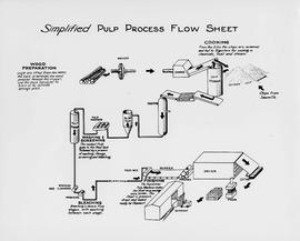
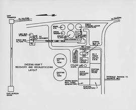
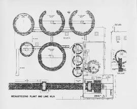
Item is a diagram of recausticizing plant and lime kiln.
Mckay, Joseph William. "Recollections of a chief trader in the Hudson's Bay Company." 1878 Hubert Howe Bancroft Collection. Bancroft Library, University of California, Berkley. BANC MSS P-C 24.
Details from Bancroft Library:
McKay came from Canada to Fort Vancouver in the Hudson's Bay Company service in 1844. Describes disturbed conditions in the old Oregon country, in consequence of the American influx; duties in 1845-1846 escorting British officers; visit to San Francisco and Hawaii in 1846 on Company business; Frémont's activities; experiences in charge of Fort Simpson, 1846-1849; relations with the Russian American Company and Indians of the Northwest Coast; duties on Vancouver Island, 1850; discovery of gold on Queen Charlotte Island, 1851, and of coal at Bellingham Bay, 1853; life at Fort Simpson during the Crimean War. Includes typed transcript. (21p. )
Chismore, George. "Record of travel from Skeena Mouth to Peace River mines." George Chismore Papers. 1871-1900. Bancroft Library, University of California, Berkley. BANC MSS 81/24p.
Details from Bancroft Library:
Include: journal of journey to Peace River Mines, British Columbia, June-Dec. 1871, with descriptions of mines and mining, encounters with Indians, and an account of performing surgery on an injured miner; eleven journals, 1883-1893, primarily of hunting trips to Rogue River, Oregon, and one journal of trip to Siskyous, with descriptions of wilderness, life in hunting camp, account of associations with black ex-slave woodsman-hunter of Rogue River area; journal of trip to St. Petersburg, Russia, June-Sept. 1898, with descriptions of museums, churches, palaces, impressions of life in St. Petersburg, Moscow and other European cities; journal of trip to Panama, Jan.-March 1900; collection of speeches to Bohemian Club; collection of his poems, ca. 1897. Also includes articles about Chismore's medical career. (32p.)
Reports as follows: Number 2. Report of the Exploration from Quesnal to Lake Tatla, via Natla and Nakosla, by Major Frank L. Pope. 1865. Title page, map, and pages 1-36. (Pages 15-17: Indian tribes; pages 32-36: vocabulary of "Siccany" (Sekani) tribe, living n. w. of Lake Tatla.) Number 3. Report of the British Columbia and Stekine Exploring Expedition, by Major Frank L Pope. 1866. Title page and pages 1-42. (Pages 27-28: Indian tribes; pages 29-30, Trading with Indians.) Number 4. Report of the Lake Babine and Skeena River Exploration, by Captain James L. Butler. 1866. 19 pages. Number 5. Report of the Atnah & Northern Explorations, by Captain J. Trimble Rothrock. 1866. 10 pages. Number 6. Report of Provisions Expended by the Stekine Exploring party; and proposed plan of an exploration from the Stekine to the Youkon, by George Blenkinsop. 1866. 8 pages, including map.
Item is a diagram of the layout of Skeena Kraft recovery and recausticizing.
Pope, Frank L. “Sketch Map Showing the Proposed Route of the Western Union Telegraph Between Fort Frazer and the Stekine River, British Columbia. From exploration by the party under the command of Maj. Frank L. Pope Ass’t Engineer, 1866.
Colour-coded B.C. provincial map depicting sustained-yield units and tree-farm licenses. The area and company names of sustained-yield units (red) and tree-farm licences (green) are explicated in a table.
Item is a map of British Columbia's Status of Sustained-Yield Forestry Programme as at 31 December 1962. The map has been annotated to show forest area surveyed by Celgar Ltd. as base for new kraft mill.
Item consists of a map of British Columbia showing Status of Sustained-Yield Forestry Programme as at December 31, 1969 with colour coded areas indicating Public Sustained Yield Units, Special Scale Areas, Tree Farm Licences, and Major Parks.
Topographic map depicting regions, communities, government posts. bodies of water, transport routes, surveyed areas, and reserves.
Colour-coded topographic map depicting lands surveyed as alienated, available for purchase or lease under Land Act, or reserved. Depicts land district boundaries, land recording divisions, provincial forest boundaries, HBC posts, triangulation stations, telephone lines, communities, bodies of water, and transport routes.
Disc contains a single file, "GGR 2A.ppt", which is a PowerPoint presentation by Gary Runka entitled "The Agriculture Land Reserve: What it is and how it got here" created April 18, 2002.
This "The Land is Yours" film is a promotional film produced by the British Columbia Department of Agriculture in Kelowna, ca. 1968 or 1969. The film was produced by Gary Runka and hosted by Russ Richardson. Runka and Richardson provide commentary throughout the film. The film was directed by Nobert Hartig.
A VHS tape containing "The Mark of Progress" film created by the British Columbia Forest Service and first played for a live audience in 1959 in Prince George, BC.
Map depicts the route of BC Rail and its connecting rail lines.
Topographic map depicting regions, communities, unexplored areas, bodies of water, transport routes, and glaciers.
Attached description: The graph indicates how Skeena Kraft pulping characteristics compare with the burst-tear properties of other bleached kraft market pulps. In this relationship, Skeena Kraft develops the high bursting strength typical of northern Canadian krafts while retaining a distinct advantage in tearing strength.