Title and statement of responsibility area
Title proper
General material designation
Cartographic material
Parallel title
Other title information
Title statements of responsibility
Title notes
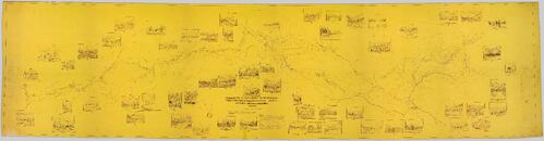
- Statements of responsibility: Reconnaissance 'track' survey in 1934 and plan in 1935-36 by E.C.W. Lamarque D.L.S., B.C.L.S. in charge of exploratory work for Charles E Bedaux's 1934 expedition in northern British Columbia. Drawings in 1936 and 1937.
Level of description
Reference code
Edition area
Edition statement
Edition statement of responsibility
Class of material specific details area
Statement of scale (cartographic)
Statement of projection (cartographic)
Statement of coordinates (cartographic)
Statement of scale (architectural)
Issuing jurisdiction and denomination (philatelic)
Dates of creation area
Date(s)
-
[1937?] (Creation)
Physical description area
Physical description
1 map : 314.6 x 79.5 cm
Publisher's series area
Title proper of publisher's series
Parallel titles of publisher's series
Other title information of publisher's series
Statement of responsibility relating to publisher's series
Numbering within publisher's series
Note on publisher's series
Archival description area
Custodial history
TR-0364 (received 2006 from BC Archives)
TR-0587 (received 2011 from J.B. Fulton)
Scope and content
Northern BC Archives holds a photocopy and a more contemporary reproduction (exact date unknown) of Lamarque's "Plan of the region about the 58th parallel from longitude 124 30' to longitude 130 west, northern British Columbia, Canada" that documents the Bedaux Expedition route through northern BC. This very lengthy map includes inset sketches of various locations along the Bedaux Expedition route.
Notes area
Physical condition
Immediate source of acquisition
Arrangement
Language of material
English
Script of material
Location of originals
Original map held by Library and Archives Canada or BC Archives.
Availability of other formats
Digitized and available in TIFF, JPEG, and PDF formats.
Restrictions on access
No restrictions.
Terms governing use, reproduction, and publication
Personal or academic use of materials is welcomed under the standard fair dealing and educational use clauses of Canadian Copyright Law. Commercial use is, however, forbidden without the express permission of the copyright holder. For information on obtaining written permission from the copyright holder, please contact the Northern B.C. Archives and Special Collections.